파일:Caltrain map.svg

SVG 파일의 PNG 형식의 미리보기 크기: 608 × 599 픽셀. 다른 해상도: 243 × 240 픽셀 | 487 × 480 픽셀 | 779 × 768 픽셀 | 1,039 × 1,024 픽셀 | 2,077 × 2,048 픽셀 | 7,476 × 7,370 픽셀
원본 파일 (SVG 파일, 실제 크기 7,476 × 7,370 픽셀, 파일 크기: 38 KB)
파일 설명
| 설명 | |
| 출처 |
다음을 기초로 한 자작: Image:Wfm caltrain.png/source. |
| 저자 | User:Finlay McWalter |
| 다른 버전 |
Caltrain map horizontal.svg:  |
| SVG 발전 |
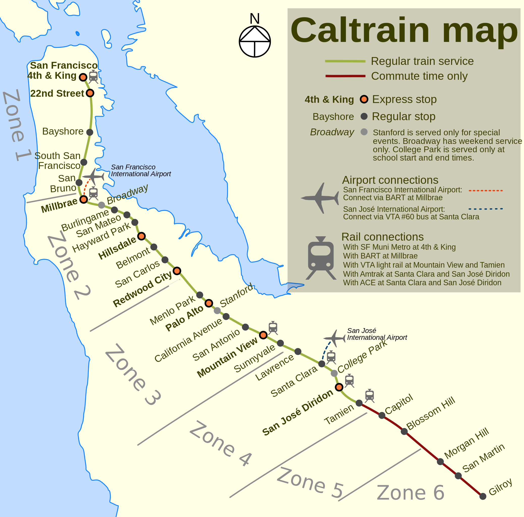
Method of production
Drawn by Finlay McWalter in the following manner:
- An outline was rendered using Panmap running NOAA WVS (world vector shoreline).
- This was exported (as a bitmap, all that Panmap can do) to Paint Shop Pro. This was manually repaired (holes filled, island groups tweaked, and shoreline details clarified or erased). Then the bitmap was floodfilled, so that the subsequent vectoriser will produce polygons rather than lines.
- This was imported into Inkscape and vectorised using Inkscape's "path->trace bitmap" function.
- All details were then manually drawn.
Notes
Differences between this version and the offical Caltrain map:
- The official Caltrain map is copyrighted by PCJPB.
- It's bigger than the Caltrain map, and clearer when printed.
- The official map doesn't denote express stops.
- The official version doesn't have acute over e in San José.
- This version shows the ACE interchange at Santa Clara, which the official one doesn't.
라이선스

|
GNU 자유 문서 사용 허가서 1.2판 또는 자유 소프트웨어 재단에서 발행한 이후 판의 규정에 따라 본 문서를 복제하거나 개작 및 배포할 수 있습니다. 본 문서에는 변경 불가 부분이 없으며, 앞 표지 구절과 뒷 표지 구절도 없습니다. 본 사용 허가서의 전체 내용은 GNU 자유 문서 사용 허가서 부분에 포함되어 있습니다. |
| 이 파일은 크리에이티브 커먼즈 저작자표시-동일조건변경허락 3.0 Unported 라이선스로 배포됩니다. | ||
| ||
| 이 라이선스 틀은 GFDL 라이선스 변경의 일부로 이 파일에 추가되었습니다. |
이 파일은 크리에이티브 커먼즈 저작자표시-동일조건변경허락 1.0 일반 라이선스로 배포됩니다.
- 이용자는 다음의 권리를 갖습니다:
- 공유 및 이용 – 저작물의 복제, 배포, 전시, 공연 및 공중송신
- 재창작 – 저작물의 개작, 수정, 2차적저작물 창작
- 다음과 같은 조건을 따라야 합니다:
- 저작자표시 – 적절한 저작자 표시를 제공하고, 라이센스에 대한 링크를 제공하고, 변경사항이 있는지를 표시해야 합니다. 당신은 합리적인 방식으로 표시할 수 있지만, 어떤 방식으로든 사용권 허가자가 당신 또는 당신의 사용을 지지하는 방식으로 표시할 수 없습니다.
- 동일조건변경허락 – If you alter, transform, or build upon this work, you must distribute the resulting work under the same license as the original.
파일 역사
날짜/시간 링크를 클릭하면 해당 시간의 파일을 볼 수 있습니다.
| 날짜/시간 | 섬네일 | 크기 | 사용자 | 설명 | |
|---|---|---|---|---|---|
| 현재 | 2024년 4월 3일 (수) 17:33 | | 7,476 × 7,370 (38 KB) | Saucy | Update to reflect current service |
| 2018년 1월 22일 (월) 08:28 |  | 7,476 × 7,370 (39 KB) | JoKalliauer | upon request User_talk:Mliu92#Sorry_for_edditing_File:Sheffield_Area_1950.svg, took version of (03:56, 23. Aug. 2006) | |
| 2015년 5월 22일 (금) 06:12 |  | 748 × 737 (125 KB) | Mliu92 | Accidentally uploaded older copy of the file last time. | |
| 2015년 5월 22일 (금) 06:10 |  | 748 × 737 (125 KB) | Mliu92 | Completely deleted old station labels and retyped from scratch to flush out legacy fonts. | |
| 2015년 5월 22일 (금) 05:44 |  | 748 × 737 (133 KB) | Mliu92 | Another iteration. Directly replaced all instances of "Trebuchet MS" with "Bitstream Vera Sans". | |
| 2015년 5월 22일 (금) 05:40 |  | 748 × 737 (133 KB) | Mliu92 | Another attempt to fix the fonts. Some direct .svg cleanup may be required if this doesn't work. | |
| 2015년 5월 22일 (금) 04:29 |  | 748 × 737 (132 KB) | Mliu92 | Updated font (from proprietary "Trebuchet MS" to free "Bitstream Vera Sans") to improve display and readability, modified legend layout (selective bolding), changed special service stop icon and modified notes on special stops, condensed rail connectio... | |
| 2006년 8월 23일 (수) 12:56 |  | 748 × 737 (134 KB) | ChrisRuvolo | update express stations based on current data (no differentiation between A and B express groups) | |
| 2006년 8월 23일 (수) 01:31 |  | 748 × 737 (134 KB) | ChrisRuvolo | remove Bayshore, fix up legend | |
| 2006년 8월 22일 (화) 00:40 |  | 748 × 737 (136 KB) | ChrisRuvolo | break-up "Stanford Stadium" labeling, shrink size of compass rose |
이 파일을 사용하는 문서
다음 문서 1개가 이 파일을 사용하고 있습니다:
이 파일을 사용하고 있는 모든 위키의 문서 목록
다음 위키에서 이 파일을 사용하고 있습니다:
- bg.wikipedia.org에서 이 파일을 사용하고 있는 문서 목록
- de.wikipedia.org에서 이 파일을 사용하고 있는 문서 목록
- de.wikivoyage.org에서 이 파일을 사용하고 있는 문서 목록
- en.wikipedia.org에서 이 파일을 사용하고 있는 문서 목록
- en.wikivoyage.org에서 이 파일을 사용하고 있는 문서 목록
- eo.wikipedia.org에서 이 파일을 사용하고 있는 문서 목록
- it.wikivoyage.org에서 이 파일을 사용하고 있는 문서 목록
- www.wikidata.org에서 이 파일을 사용하고 있는 문서 목록