파일:Carte des Hammadides et leurs voisins v.1050 (English cropped).png

미리 보기 크기: 800 × 450 픽셀 다른 해상도: 320 × 180 픽셀 | 640 × 360 픽셀 | 1,024 × 576 픽셀 | 1,280 × 720 픽셀 | 2,560 × 1,441 픽셀 | 4,503 × 2,534 픽셀
원본 파일 (4,503 × 2,534 픽셀, 파일 크기: 1,019 KB, MIME 종류: image/png)
.png?uselang=ko)
파일 설명
| 설명 |
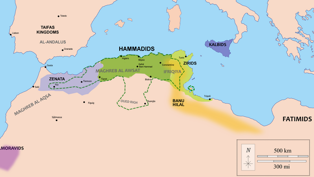
English: Map of the Hammadid realm (green) and their neighbours, with extended or maximal territories in dotted line (controlled in different periods, mostly during the reign of al-Nasir).
The original file cited these as sources:
My own addendum to these sources:
|
| 날짜 | |
| 출처 | Wiki Commons (Carte des Hammadides et leurs voisins v.1050.png) |
| 저자 | (minor edits by R Prazeres) |
라이선스
이 파일은 크리에이티브 커먼즈 저작자표시-동일조건변경허락 4.0 국제 라이선스로 배포됩니다.
- 이용자는 다음의 권리를 갖습니다:
- 공유 및 이용 – 저작물의 복제, 배포, 전시, 공연 및 공중송신
- 재창작 – 저작물의 개작, 수정, 2차적저작물 창작
- 다음과 같은 조건을 따라야 합니다:
- 저작자표시 – 적절한 저작자 표시를 제공하고, 라이센스에 대한 링크를 제공하고, 변경사항이 있는지를 표시해야 합니다. 당신은 합리적인 방식으로 표시할 수 있지만, 어떤 방식으로든 사용권 허가자가 당신 또는 당신의 사용을 지지하는 방식으로 표시할 수 없습니다.
- 동일조건변경허락 – 만약 당신이 이 저작물을 리믹스 또는 변형하거나 이 저작물을 기반으로 제작하는 경우, 당신은 당신의 기여물을 원저작물과 동일하거나 호환 가능한 라이선스에 따라 배포하여야 합니다.
파일 역사
날짜/시간 링크를 클릭하면 해당 시간의 파일을 볼 수 있습니다.
| 날짜/시간 | 섬네일 | 크기 | 사용자 | 설명 | |
|---|---|---|---|---|---|
| 현재 | 2022년 4월 13일 (수) 03:09 | | 4,503 × 2,534 (1,019 KB) | R Prazeres | Fixed unintended white margins |
| 2022년 4월 13일 (수) 03:06 |  | 4,619 × 2,558 (1.01 MB) | R Prazeres | Uploaded a work by Kabyle20 (minor edits by R Prazeres) from Wiki Commons (Carte des Hammadides et leurs voisins v.1050.png) with UploadWizard |
이 파일을 사용하는 문서
다음 문서 1개가 이 파일을 사용하고 있습니다:
이 파일을 사용하고 있는 모든 위키의 문서 목록
다음 위키에서 이 파일을 사용하고 있습니다:
- ar.wikipedia.org에서 이 파일을 사용하고 있는 문서 목록
- en.wikipedia.org에서 이 파일을 사용하고 있는 문서 목록
- fi.wikipedia.org에서 이 파일을 사용하고 있는 문서 목록
- nl.wikipedia.org에서 이 파일을 사용하고 있는 문서 목록
.png)