파일:Corrientes-oceanicas-en.svg

SVG 파일의 PNG 형식의 미리보기 크기: 800 × 404 픽셀. 다른 해상도: 320 × 162 픽셀 | 640 × 323 픽셀 | 1,024 × 517 픽셀 | 1,280 × 647 픽셀 | 2,560 × 1,293 픽셀 | 976 × 493 픽셀
원본 파일 (SVG 파일, 실제 크기 976 × 493 픽셀, 파일 크기: 1.63 MB)
파일 설명
| 설명 |
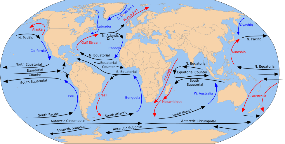
English: A detailed Robinson-projection SVG map with grouping enabled to connect all non-contiguous parts of a country's territory for easy colouring. Smaller countries can also be represented by larger circles to show their data easier. A thorough description of use and other instructions relating to can be found on the instruction page. |
| 날짜 | (UTC) |
| 출처 |
이 파일은 다음에 의해 파생됨: Blank map of the world (Robinson projection) (10E).svg: 이 파일은 다음에 의해 파생됨: Corrientes-oceanicas.png: |
| 저자 |
|
_(10E).svg)

|
이 SVG 파일은 편집 가능한 문자를 사용하므로 Inkscape나 Adobe Illustrator를 사용하여 쉽게 다른 언어로 번역할 수 있습니다. 여기를 참고하세요. 또한 텍스트 편집기를 이용하여 수동으로 파일을 번역할 수도 있습니다. |
라이선스
나는 아래 작품의 저작권자로서, 이 저작물을 다음과 같은 라이선스로 배포합니다:
| 나는 이 작품의 저작권자로서, 이 작품을 퍼블릭 도메인으로 모두에게 공개합니다. 이 공개 선언은 전 세계적으로 유효합니다. 만약 저작권의 포기가 법률적으로 가능하지 않은 경우, 나는 이 작품을 법적으로 허용되는 한도 내에서 누구나 자유롭게 어떤 목적으로도 제한없이 사용할 수 있도록 허용합니다. |
기존 올리기 기록
This image is a derivative work of the following images:
- File:Blank map of the world (Robinson projection) (10E).svg licensed with PD-self
- 2011-05-16T04:18:31Z Milenioscuro 3100x1600 (2087786 Bytes) {{Information |Description={{en|1=A detailed Robinson-projection [[Help:SVG|SVG]] map with grouping enabled to connect all non-contiguous parts of a country's territory for easy colouring. Smaller countries can also be repres
Uploaded with derivativeFX
파일 역사
날짜/시간 링크를 클릭하면 해당 시간의 파일을 볼 수 있습니다.
| 날짜/시간 | 섬네일 | 크기 | 사용자 | 설명 | |
|---|---|---|---|---|---|
| 현재 | 2023년 7월 31일 (월) 02:43 | | 976 × 493 (1.63 MB) | Matěj Grabovský | File uploaded using svgtranslate tool (https://svgtranslate.toolforge.org/). Added translation for cs. |
| 2014년 12월 16일 (화) 03:08 |  | 976 × 493 (1.67 MB) | RicHard-59 | Guls -> Gulf | |
| 2014년 4월 28일 (월) 23:20 |  | 976 × 493 (1.58 MB) | Moja~commonswiki | Correct "Oyashia" -> "Oyashio" | |
| 2012년 8월 17일 (금) 23:51 |  | 976 × 493 (1.66 MB) | Popadius | Reverted to version as of 14:42, 17 August 2012 | |
| 2012년 8월 17일 (금) 23:49 |  | 976 × 493 (1.1 MB) | Popadius | small fix | |
| 2012년 8월 17일 (금) 23:42 |  | 976 × 493 (1.66 MB) | Popadius | == {{int:filedesc}} == {{Information |Description={{en|1=A detailed Robinson-projection SVG map with grouping enabled to connect all non-contiguous parts of a country's territory for easy colouring. Smaller countries can also be represente... |
이 파일을 사용하는 문서
다음 문서 1개가 이 파일을 사용하고 있습니다:
이 파일을 사용하고 있는 모든 위키의 문서 목록
다음 위키에서 이 파일을 사용하고 있습니다:
- ca.wikipedia.org에서 이 파일을 사용하고 있는 문서 목록
- cs.wikipedia.org에서 이 파일을 사용하고 있는 문서 목록
- de.wikipedia.org에서 이 파일을 사용하고 있는 문서 목록
- en.wikipedia.org에서 이 파일을 사용하고 있는 문서 목록
- eo.wikipedia.org에서 이 파일을 사용하고 있는 문서 목록
- es.wikipedia.org에서 이 파일을 사용하고 있는 문서 목록
- eu.wikipedia.org에서 이 파일을 사용하고 있는 문서 목록
- Ozeano Australa
- Golkoko itsaslasterra
- Humboldt itsaslasterra
- Agulhasko itsaslasterra
- Alaskako itsaslasterra
- Itsaslaster Zirkunpolar Antartikoa
- Antilletako itsaslasterra
- Benguelako itsaslasterra
- Brasilgo itsaslasterra
- Kaliforniako itsaslasterra
- Kanarietako itsaslasterra
- Floridako itsaslasterra
- Azoreetako itsaslasterra
- Karibeko itsaslasterra
- Cromwell itsaslasterra
- Ekialdeko Australiako itsaslasterra
- Groenlandiako ekialdeko itsaslasterra
- Madagaskarko ekialdeko itsaslasterra
- Malvinetako itsaslasterra
- Gineako itsaslasterra
- Irminger itsaslasterra
- Kuroshio itsaslasterra
- Oyashio itsaslasterra
- Labradorko itsaslasterra
- Leeuwingo itsaslasterra
- Lomonosov itsaslasterra
- Madagaskarko itsaslasterra
- Mindanaoko itsaslasterra
- Mozambikeko itsaslasterra
- Ipar Atlantikoko itsaslasterra
- Iparraldeko itsaslaster ekuatoriala
- Kontralaster Ekuatoriala
- Ipar Pazifikoko itsaslasterra
- Norvegiako itsaslasterra
이 파일의 더 많은 사용 내역을 봅니다.