파일:Daedelus comparison, remote sensing in precision farming.jpg
미리 보기 크기: 366 × 598 픽셀 다른 해상도: 147 × 240 픽셀 | 540 × 883 픽셀
원본 파일 (540 × 883 픽셀, 파일 크기: 143 KB, MIME 종류: image/jpeg)
| 설명 |
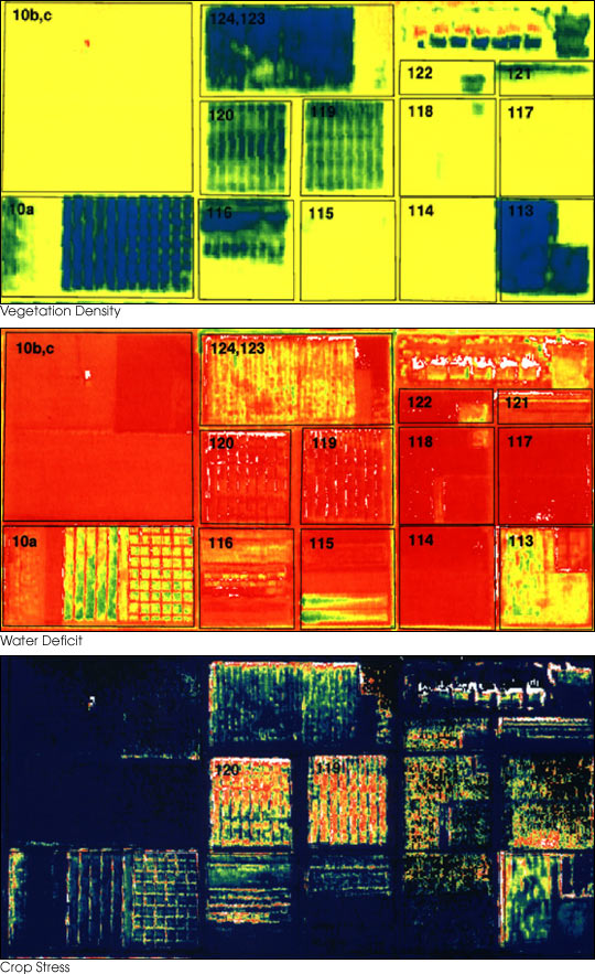
English: These three false-color images demonstrate some of the applications of remote sensing in precision farming. The goal of precision farming is to improve farmers’ profits and harvest yields while reducing the negative impacts of farming on the environment that come from over-application of chemicals. The images were acquired by the Daedalus sensor aboard a NASA aircraft flying over the Maricopa Agricultural Center in Arizona.
|
|||||
| 날짜 | before 2001년 1월 30일 | |||||
| 출처 | earthobservatory.nasa.gov (NASA Earth Observatory, Image of the Day 2001-01-30 "Precision Farming") | |||||
| 저자 | Susan Moran, Landsat 7 Science Team and USDA Agricultural Research Service (U.S. Government work) | |||||
| 저작권 (이 파일을 인용하기) |
|
|||||
| 다른 버전 |
.jpg) |

파일 역사
날짜/시간 링크를 클릭하면 해당 시간의 파일을 볼 수 있습니다.
| 날짜/시간 | 섬네일 | 크기 | 사용자 | 설명 | |
|---|---|---|---|---|---|
| 현재 | 2010년 6월 28일 (월) 10:10 | | 540 × 883 (143 KB) | Bdk | {{Information |Description={{en|These three false-color images demonstrate some of the applications of remote sensing in precision farming. The goal of precision farming is to improve farmers’ profits and harvest yields whi |
이 파일을 사용하는 문서
다음 문서 1개가 이 파일을 사용하고 있습니다:
이 파일을 사용하고 있는 모든 위키의 문서 목록
다음 위키에서 이 파일을 사용하고 있습니다:
- ar.wikipedia.org에서 이 파일을 사용하고 있는 문서 목록
- en.wikipedia.org에서 이 파일을 사용하고 있는 문서 목록
- en.wikiversity.org에서 이 파일을 사용하고 있는 문서 목록
- eu.wikipedia.org에서 이 파일을 사용하고 있는 문서 목록
- fr.wikipedia.org에서 이 파일을 사용하고 있는 문서 목록
- id.wikipedia.org에서 이 파일을 사용하고 있는 문서 목록
- it.wikipedia.org에서 이 파일을 사용하고 있는 문서 목록
- ja.wikipedia.org에서 이 파일을 사용하고 있는 문서 목록
- ms.wikipedia.org에서 이 파일을 사용하고 있는 문서 목록
- oc.wikipedia.org에서 이 파일을 사용하고 있는 문서 목록
- ru.wikipedia.org에서 이 파일을 사용하고 있는 문서 목록
- ta.wikipedia.org에서 이 파일을 사용하고 있는 문서 목록
- te.wikipedia.org에서 이 파일을 사용하고 있는 문서 목록
- tr.wikipedia.org에서 이 파일을 사용하고 있는 문서 목록
- uk.wikipedia.org에서 이 파일을 사용하고 있는 문서 목록
- www.wikidata.org에서 이 파일을 사용하고 있는 문서 목록