파일:Dc10erebus.png

원본 파일 (818 × 558 픽셀, 파일 크기: 159 KB, MIME 종류: image/png)
파일 설명
| 설명 |
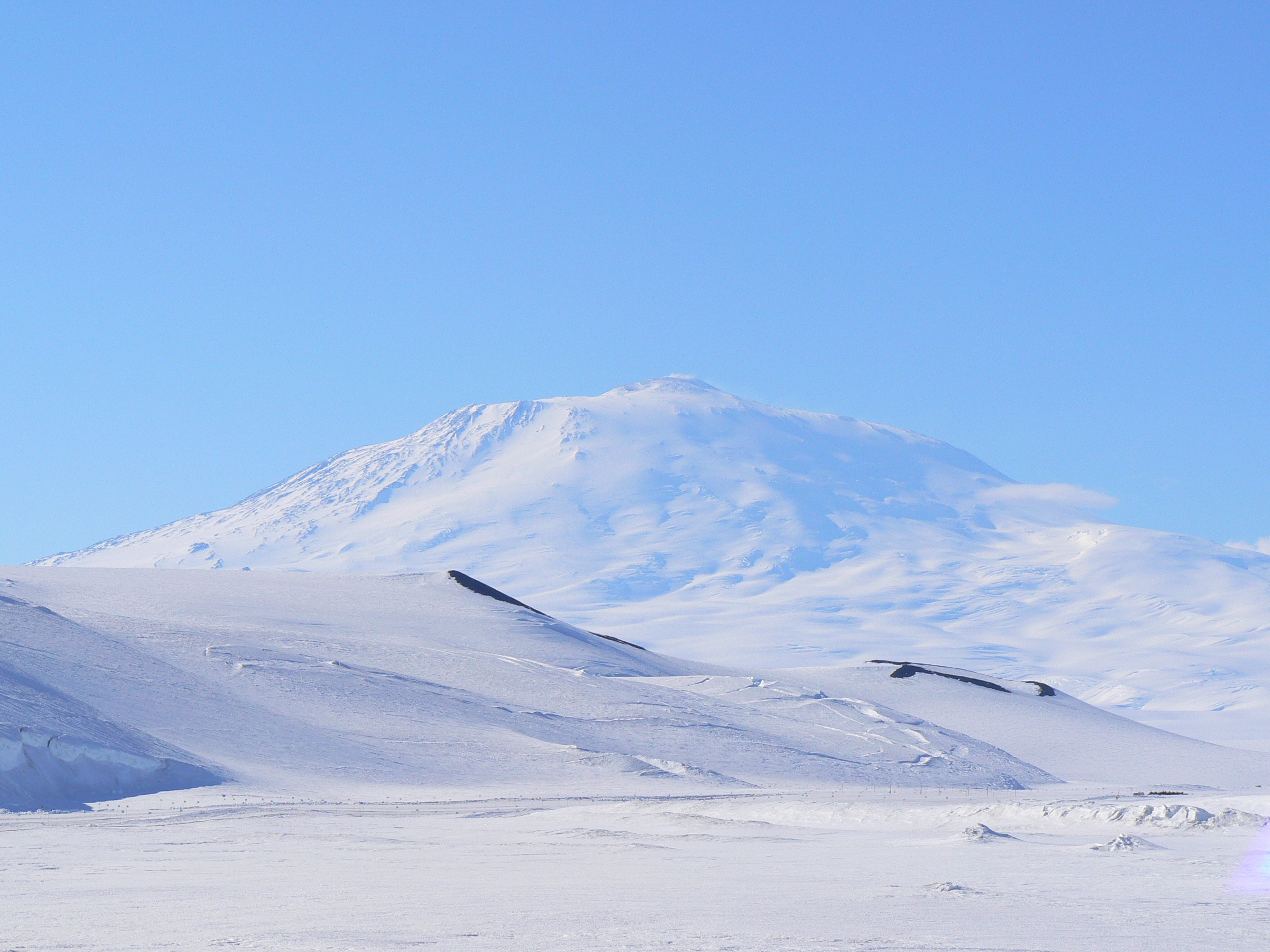
"Go-around power please." Français : Image de synthèse illustrant le vol 901 d'Air New Zealand avant son impact sur le mont Ross. |
| 날짜 | (UTC) |
| 출처 |
model made with textures made with
terrain made with Terragen final editing done with GIMP I also used these images to get an idea of what Erebus looks like in various conditions: A clear day, light clouds, from the summit among others available at the USAP's photolibrary. Used photos from Airliners.net for research material on ZK-NZP and Air New Zealand livery
The latest version directly reflects this description Judgments of the Court of Appeal of New Zealand on Proceedings to Review Aspects of the Report of the Royal Commission of Inquiry into the Mount Erebus Aircraft Disaster, by Sir Owen Woodhouse, R. B. Cooke, Ivor L. M. Richardson, Duncan Wallace McMullin, and Sir Edward Somers I have already made it clear that the aircraft struck the lower slopes of Mt. Erebus whilst flying in clear air. The DC10 was at the time flying under a total cloud cover which extended forward until it met the mountain-side at an altitude of somewhere between 2000 and 2500 feet. The position of the sun at the time of impact was directly behind the aircraft, being in a position approximately to the true north of the mountain and shining at an inclination of 34°. The co-existence of these factors produced without doubt the classic 'whiteout' phenomenon which occurs from time to time in polar regions, or in any terrain totally covered by snow. Very extensive evidence was received by the Commission as to the occurrence and the consequences of this weather phenomenon. So long as the view ahead from the flight deck of an aircraft flying over snow under a solid overcast does not exhibit any rock, or tree, or other landmark which can offer a guide as to sloping or uneven ground, then the snow-covered terrain ahead of the aircraft will invariably appear to be flat. Slopes and ridges will disappear. The line of vision from the flight deck towards the horizon (if there is one) will actually portray a white even expanse which is uniformly level. What this air crew saw ahead of them as the aircraft levelled out at 3000 feet and then later at 1500 feet was a long vista of flat snow-covered terrain, extending ahead for miles. Similarly, the roof of the solid overcast extended forward for miles. In the far distance the flat white terrain would either have appeared to have reached the horizon many miles away or, more probably, merged imperceptibly with the overhead cloud thus producing no horizon at all. What the crew could see, therefore, was what appeared to be the distant stretch of flat white ground representing the flat long corridor of McMurdo Sound. In reality the flat ground ahead proceeded for only about 6 miles before it intercepted the low ice cliff which marked the commencement of the icy slope leading upwards to the mountain, and at that point the uniform white surface of the mountain slope proceeded upwards, first at an angle of 13°, and then with a gradually increasing upward angle as it merged with the ceiling of the cloud overhead. The only feature of the forward terrain which was not totally white consisted of two small and shallow strips of black rock at the very bottom of the ice cliff, and these could probably not be seen from the flight deck seats owing to the nose-up attitude of 5° at which the aircraft was travelling, or they were mistaken for thin strips of sea previously observed by the crew as separating blocks of pack ice. The aircraft had thus encountered, at a fateful coincidence in time, the insidious and unidentifiable terrain deception of a classic whiteout situation. They had encountered that type of visual illusion which makes rising white plateaux appear perfectly flat. This freak of polar weather is known and feared by every polar flier. In some Arctic regions in the Canadian and in the north European winter, it is responsible for numbers of light aircraft crashes every year. Aircraft fly, in clear air, directly into hills and mountains. But neither Captain Collins nor First Officer Cassin had ever flown at low altitude in polar regions before. Even Mr Mulgrew [the commentator for the passengers], with his antarctic experience, was completely deceived. The fact that not one of the five persons on the flight deck ever identified the rising terrain confirms the totality of this weird and dangerous ocular illusion as it existed on the approach to Mt. Erebus at 12.50 p.m. on 28 November 1979. |
| 저자 | Anynobody |
| 다른 버전 |
|
라이선스

|
GNU 자유 문서 사용 허가서 1.2판 또는 자유 소프트웨어 재단에서 발행한 이후 판의 규정에 따라 본 문서를 복제하거나 개작 및 배포할 수 있습니다. 본 문서에는 변경 불가 부분이 없으며, 앞 표지 구절과 뒷 표지 구절도 없습니다. 본 사용 허가서의 전체 내용은 GNU 자유 문서 사용 허가서 부분에 포함되어 있습니다. |
- 이용자는 다음의 권리를 갖습니다:
- 공유 및 이용 – 저작물의 복제, 배포, 전시, 공연 및 공중송신
- 재창작 – 저작물의 개작, 수정, 2차적저작물 창작
- 다음과 같은 조건을 따라야 합니다:
- 저작자표시 – 적절한 저작자 표시를 제공하고, 라이센스에 대한 링크를 제공하고, 변경사항이 있는지를 표시해야 합니다. 당신은 합리적인 방식으로 표시할 수 있지만, 어떤 방식으로든 사용권 허가자가 당신 또는 당신의 사용을 지지하는 방식으로 표시할 수 없습니다.
- 동일조건변경허락 – 만약 당신이 이 저작물을 리믹스 또는 변형하거나 이 저작물을 기반으로 제작하는 경우, 당신은 당신의 기여물을 원저작물과 동일하거나 호환 가능한 라이선스에 따라 배포하여야 합니다.
파일 역사
날짜/시간 링크를 클릭하면 해당 시간의 파일을 볼 수 있습니다.
| 날짜/시간 | 섬네일 | 크기 | 사용자 | 설명 | |
|---|---|---|---|---|---|
| 현재 | 2012년 11월 20일 (화) 13:52 | | 818 × 558 (159 KB) | Anynobody~commonswiki | oops, last one was the wrong one... |
| 2012년 11월 20일 (화) 05:44 |  | 1,237 × 1,215 (662 KB) | Anynobody~commonswiki | hypothetical view from below, with air glow, sub-surface scattering and cloud interaction on DEM of Ross Island | |
| 2009년 4월 20일 (월) 04:54 |  | 2,080 × 1,224 (611 KB) | Anynobody~commonswiki | better clouds and environment | |
| 2008년 12월 4일 (목) 16:25 |  | 1,620 × 1,200 (309 KB) | Anynobody~commonswiki | Enhanced | |
| 2008년 9월 28일 (일) 14:13 |  | 1,620 × 1,280 (550 KB) | Anynobody~commonswiki | modeled Ross island, included Blender lighting and shadow effects to recreate approximation of actual whiteout effect | |
| 2008년 5월 22일 (목) 13:03 |  | 3,200 × 2,400 (2.22 MB) | Anynobody~commonswiki | fixed exhaust | |
| 2008년 5월 22일 (목) 10:17 |  | 3,200 × 2,400 (2.27 MB) | Anynobody~commonswiki | new model, actually modeled Erebus rather than simply drawing it | |
| 2008년 2월 6일 (수) 08:31 |  | 1,600 × 1,200 (1.09 MB) | Anynobody~commonswiki | {{Information |Description=Air New Zealand Flight 901 approaching Mt. Erebus |Source=self-made |Date= ~~~~~ |Author= Anynobody |Permission= |other_versions= }} |
이 파일을 사용하는 문서
다음 문서 1개가 이 파일을 사용하고 있습니다:
이 파일을 사용하고 있는 모든 위키의 문서 목록
다음 위키에서 이 파일을 사용하고 있습니다:
- en.wikipedia.org에서 이 파일을 사용하고 있는 문서 목록
- es.wikipedia.org에서 이 파일을 사용하고 있는 문서 목록
- fr.wikipedia.org에서 이 파일을 사용하고 있는 문서 목록
- ja.wikipedia.org에서 이 파일을 사용하고 있는 문서 목록
- oc.wikipedia.org에서 이 파일을 사용하고 있는 문서 목록
- ru.wikipedia.org에서 이 파일을 사용하고 있는 문서 목록
- zh.wikipedia.org에서 이 파일을 사용하고 있는 문서 목록