파일:Disturnell & Schroeter Map Illustrating the Disputed Boundary Between the United States and Mexico 1853 UTA.jpg

미리 보기 크기: 800 × 468 픽셀 다른 해상도: 320 × 187 픽셀 | 640 × 375 픽셀 | 1,024 × 599 픽셀 | 1,280 × 749 픽셀 | 2,560 × 1,498 픽셀 | 4,188 × 2,451 픽셀
원본 파일 (4,188 × 2,451 픽셀, 파일 크기: 1.24 MB, MIME 종류: image/jpeg)
파일 설명
| 제목 |
English: Map illustrating the Disputed Boundary between the United States and Mexico |
||||||||||||||||||||||||||
| 묘사 |
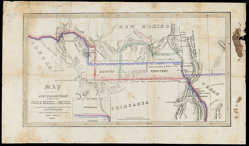
English: Soon after the U.S. and Mexican Boundary Commissions began their surveys in 1849, they noted glaring errors on the 1847 map that had been used to negotiate the Treaty of Guadalupe Hidalgo. The town of El Paso, and thus the boundary itself, had been situated too far to the north on the map, resulting in disagreements between the United States and Mexican governments over exactly where the boundary should be. The New York publisher of the original treaty map, John Disturnell, later issued this map to correct the earlier errors and to illustrate the disputed boundary lines that had resulted (the red for the U.S. claim and the blue for Mexico's). Also, as shown, Americans had learned that even with the corrections in latitude, one of the best routes to California – Cooke's Wagon Road – actually lay south of the new border, and a large lobby of U.S. citizens wanted the land to construct a railroad from El Paso to the Pacific. Given the Mexican government's need for cash, on December 30, 1853, U.S. and Mexican diplomats signed the Gadsden Purchase treaty, whereby the United States paid Mexico $10 million for 29,142,400 acres of a wedge of land within the present states of New Mexico and Arizona. |
||||||||||||||||||||||||||
| 날짜 | |||||||||||||||||||||||||||
| 출처 | UTA Libraries Cartographic Connections: 지도 / text | ||||||||||||||||||||||||||
| 창작자 |
|
||||||||||||||||||||||||||
| 크레디트 라인 |
English: UTA Libraries Special Collections |
||||||||||||||||||||||||||
| 지리 정보 | |||||||||||||||||||||||||||
| 지도 위치 |
미국 멕시코 |
||||||||||||||||||||||||||
| 지리 참고 | 부적절한 경우에 숨기려면 warp_status = skip로 설정하세요. | ||||||||||||||||||||||||||
| 서적 정보 | |||||||||||||||||||||||||||
| 출판 장소 | 뉴욕 | ||||||||||||||||||||||||||
| 인쇄자 |
|
||||||||||||||||||||||||||
| 보관 기록 자료 | |||||||||||||||||||||||||||
| Collection |
|
||||||||||||||||||||||||||
| 크기 | 높이: 22.5 cm; 너비: 40 cm | ||||||||||||||||||||||||||
| 기법 | colored lithograph | ||||||||||||||||||||||||||
| artwork-references | Wheat Mapping the Trans-Mississippi West, 3, no. 779 , pp. 236, 325 | ||||||||||||||||||||||||||
라이선스

|
This file was provided to Wikimedia Commons by the University of Texas at Arlington Libraries as part of a cooperation project. The University of Texas at Arlington Libraries is part of the University of Texas at Arlington, a public research university located in Arlington, Texas.
|
|
저작자가 1877년에 사망한 이 작품은 미국, 그리고 저작권 보호 기간이 저작자 사후 100년, 또는 그 이하인 모든 국가에서 퍼블릭 도메인입니다. 이 작품은 1929년 1월 1일 이전에 출판하였으므로 미국에서 퍼블릭 도메인입니다. | |
| 이 저작물은 모든 저작인접권을 포함한 저작권법하의 규제로부터 자유로운 것으로 확인되었습니다. | |
파일 역사
날짜/시간 링크를 클릭하면 해당 시간의 파일을 볼 수 있습니다.
| 날짜/시간 | 섬네일 | 크기 | 사용자 | 설명 | |
|---|---|---|---|---|---|
| 현재 | 2022년 3월 13일 (일) 03:50 | | 4,188 × 2,451 (1.24 MB) | Michael Barera | == {{int:filedesc}} == {{Map |title = {{en|'''''Map illustrating the Disputed Boundary between the United States and Mexico'''''}} |description = {{en|Soon after the U.S. and Mexican Boundary Commissions began their surveys in 1849, they noted glaring errors on the 1847 map that had been used to negotiate the Treaty of Guadalupe Hidalgo. The town of El Paso, and thus the boundary itself, had been situated too far to the north on the map, resulting in disagreements between... |
이 파일을 사용하는 문서
다음 문서 1개가 이 파일을 사용하고 있습니다:
이 파일을 사용하고 있는 모든 위키의 문서 목록
다음 위키에서 이 파일을 사용하고 있습니다:
- de.wikipedia.org에서 이 파일을 사용하고 있는 문서 목록
- es.wikipedia.org에서 이 파일을 사용하고 있는 문서 목록
- fr.wikipedia.org에서 이 파일을 사용하고 있는 문서 목록
- hu.wikipedia.org에서 이 파일을 사용하고 있는 문서 목록