파일:Durrani Empire 1747 1862 AD.png
미리 보기 크기: 768 × 600 픽셀 다른 해상도: 307 × 240 픽셀 | 615 × 480 픽셀 | 832 × 650 픽셀
원본 파일 (832 × 650 픽셀, 파일 크기: 105 KB, MIME 종류: image/png)
| 설명 |
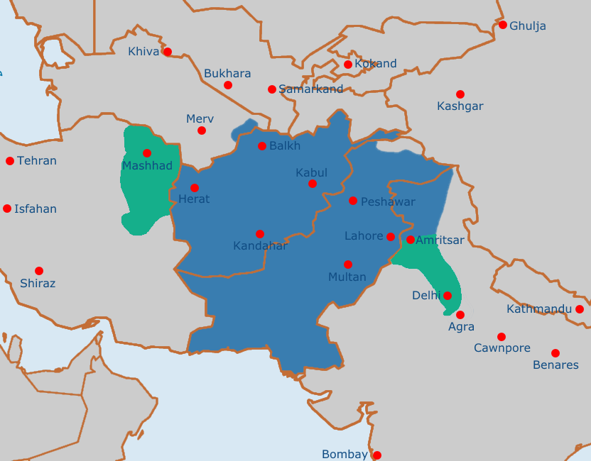
English: Map of the Afghan Durrani Empire at its greatest extent, circa late 1750s. In green is de facto (vassal) control. |
| 날짜 | |
| 출처 | https://en.wikipedia.org/wiki/File:Safavid_Empire_1501_1722_AD.png |
| 저자 | Arab Hafez and edited by me. |
이 작품은 퍼블릭 도메인으로 배포됩니다. 그 근거는 다음과 같습니다: Released into the public domain by the author.
이것이 법적으로 불가능할 경우: 저작물의 사용 근거가 라이선스 정책에 부합하는지 확인해 주시기 바랍니다.
|
파일 역사
날짜/시간 링크를 클릭하면 해당 시간의 파일을 볼 수 있습니다.
| 날짜/시간 | 섬네일 | 크기 | 사용자 | 설명 | |
|---|---|---|---|---|---|
| 현재 | 2021년 8월 4일 (수) 20:51 | | 832 × 650 (105 KB) | Weaveravel | De facto/vessel control and corrected Mashhad/Khorasan |
| 2021년 8월 4일 (수) 20:39 |  | 832 × 650 (108 KB) | Weaveravel | Improved map layout and scale, added Delhi territory (as de facto control), fixed cities geographical positions | |
| 2021년 7월 27일 (화) 03:54 |  | 1,415 × 958 (205 KB) | Weaveravel | Clearer, high quality map, more accurate labels and cities (denoting important ones) | |
| 2013년 4월 28일 (일) 23:27 |  | 620 × 429 (22 KB) | HistoryofIran | {{subst:Upload marker added by en.wp UW}} {{Information |Description = {{en|Map of the Durrani Empire at it's greatest extent.}} |Source = https://en.wikipedia.org/wiki/File:Safavid_Empire_1501_1722_AD.png |Date = 28. April 2013. |Author = Arab Hafez a... |
이 파일을 사용하는 문서
이 파일을 사용하는 문서가 없습니다.
이 파일을 사용하고 있는 모든 위키의 문서 목록
다음 위키에서 이 파일을 사용하고 있습니다:
- ar.wikipedia.org에서 이 파일을 사용하고 있는 문서 목록
- ast.wikipedia.org에서 이 파일을 사용하고 있는 문서 목록
- azb.wikipedia.org에서 이 파일을 사용하고 있는 문서 목록
- az.wikipedia.org에서 이 파일을 사용하고 있는 문서 목록
- bg.wikipedia.org에서 이 파일을 사용하고 있는 문서 목록
- bn.wikipedia.org에서 이 파일을 사용하고 있는 문서 목록
- bs.wikipedia.org에서 이 파일을 사용하고 있는 문서 목록
- ca.wikipedia.org에서 이 파일을 사용하고 있는 문서 목록
- cs.wikipedia.org에서 이 파일을 사용하고 있는 문서 목록
- de.wikipedia.org에서 이 파일을 사용하고 있는 문서 목록
- diq.wikipedia.org에서 이 파일을 사용하고 있는 문서 목록
- el.wikipedia.org에서 이 파일을 사용하고 있는 문서 목록
- en.wikipedia.org에서 이 파일을 사용하고 있는 문서 목록
- eo.wikipedia.org에서 이 파일을 사용하고 있는 문서 목록
- es.wikipedia.org에서 이 파일을 사용하고 있는 문서 목록
- et.wikipedia.org에서 이 파일을 사용하고 있는 문서 목록
- eu.wikipedia.org에서 이 파일을 사용하고 있는 문서 목록
- fa.wikipedia.org에서 이 파일을 사용하고 있는 문서 목록
- fi.wikipedia.org에서 이 파일을 사용하고 있는 문서 목록
- fr.wikipedia.org에서 이 파일을 사용하고 있는 문서 목록
- he.wikipedia.org에서 이 파일을 사용하고 있는 문서 목록
- hi.wikipedia.org에서 이 파일을 사용하고 있는 문서 목록
- hu.wikipedia.org에서 이 파일을 사용하고 있는 문서 목록
- hy.wikipedia.org에서 이 파일을 사용하고 있는 문서 목록
- it.wikipedia.org에서 이 파일을 사용하고 있는 문서 목록
- ka.wikipedia.org에서 이 파일을 사용하고 있는 문서 목록
- kn.wikipedia.org에서 이 파일을 사용하고 있는 문서 목록
- lt.wikipedia.org에서 이 파일을 사용하고 있는 문서 목록
- mn.wikipedia.org에서 이 파일을 사용하고 있는 문서 목록
- nl.wikipedia.org에서 이 파일을 사용하고 있는 문서 목록
- nn.wikipedia.org에서 이 파일을 사용하고 있는 문서 목록
- pt.wikipedia.org에서 이 파일을 사용하고 있는 문서 목록
- ru.wikipedia.org에서 이 파일을 사용하고 있는 문서 목록
- sk.wikipedia.org에서 이 파일을 사용하고 있는 문서 목록
- sv.wikipedia.org에서 이 파일을 사용하고 있는 문서 목록
- ta.wikipedia.org에서 이 파일을 사용하고 있는 문서 목록
- tg.wikipedia.org에서 이 파일을 사용하고 있는 문서 목록
- vi.wikipedia.org에서 이 파일을 사용하고 있는 문서 목록
- www.wikidata.org에서 이 파일을 사용하고 있는 문서 목록
이 파일의 더 많은 사용 내역을 봅니다.