파일:East-Hem 1000bc.jpg
원본 파일 (3,240 × 1,903 픽셀, 파일 크기: 1.43 MB, MIME 종류: image/jpeg)

|
이 그림 파일은 벡터 SVG 형식으로 다시 만들어야 합니다. SVG의 장점에 대해서는 여기(영어)를 참고해 주십시오. 만약 이 그림의 SVG 버전이 이미 존재한다면 이 틀을 {{vector version available|새 파일 이름.svg}}으로 대체해 주십시오.
|


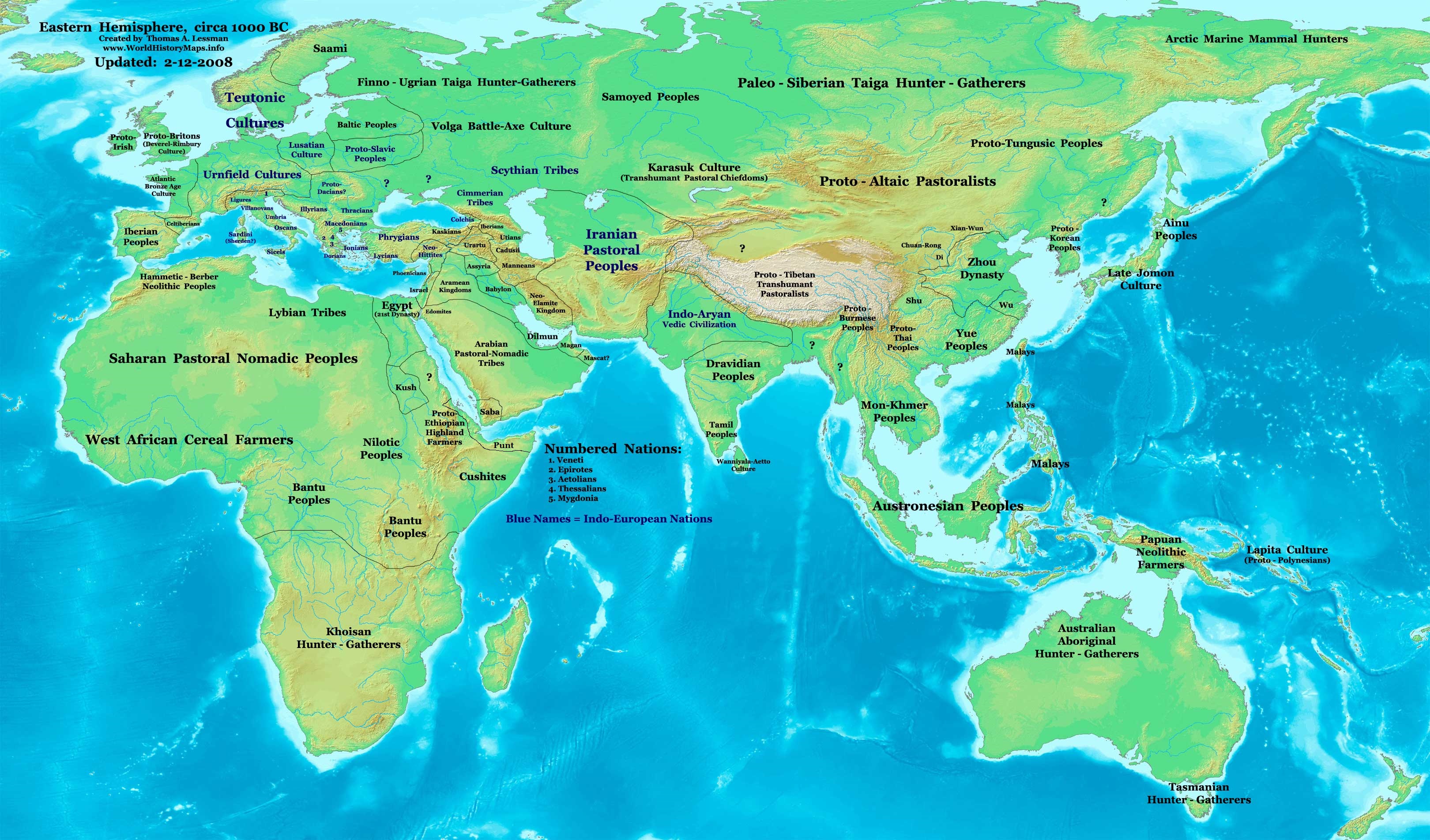
| 설명 | Eastern Hemisphere in 1000 BC. |
| 출처 | self-made (For reference information, see below) |
| 저자 | Thomas Lessman (Contact!) |
| 다른 버전 | see East-Hem_1000bc.jpg file history on Wikipedia. |
라이선스
- 이용자는 다음의 권리를 갖습니다:
- 공유 및 이용 – 저작물의 복제, 배포, 전시, 공연 및 공중송신
- 재창작 – 저작물의 개작, 수정, 2차적저작물 창작
- 다음과 같은 조건을 따라야 합니다:
- 저작자표시 – 적절한 저작자 표시를 제공하고, 라이센스에 대한 링크를 제공하고, 변경사항이 있는지를 표시해야 합니다. 당신은 합리적인 방식으로 표시할 수 있지만, 어떤 방식으로든 사용권 허가자가 당신 또는 당신의 사용을 지지하는 방식으로 표시할 수 없습니다.
- 동일조건변경허락 – 만약 당신이 이 저작물을 리믹스 또는 변형하거나 이 저작물을 기반으로 제작하는 경우, 당신은 당신의 기여물을 원저작물과 동일하거나 호환 가능한 라이선스에 따라 배포하여야 합니다.
Map Summary
Original Source URL: http://www.thomaslessman.com/History/images/East-Hem_1000bc.jpg.
This map of the Eastern Hemisphere in 1000 BC was created by Thomas Lessman, based on information from the sources listed below. This map is free for educational use (see Permission info above). When using this map, please mention that it is available for free at www.WorldHistoryMaps.info.
Map Source References
- Remember, sources often conflict with each other. This map is only as accurate as the information that is available to me. To report any errors or to help further this work, please click here, or email Thomas Lessman at talessman@yis.us
References for information contained in this map:
1. Some info derive from the map of the World 1000 BCE, created by User:Briangotts..
2. Zhou (China) borders derive partially from the Huhai.net map of China: 11th to 9th centuries BC.
3. Some information derives from DK Atlas of World History, 2000 edition.
4. Other information is based on various Wikipedia articles and google searches dealing with nations depicted in this map.
Other Maps by Thomas Lessman
| Maps of the eastern hemisphere showing history
Bold dates are available on Wikimedia or Wikipedia. | ||
| Primeval | ||
| Ancient
|
·| 600 BC | 550 BC | 527 BC | 500 BC |
400 BC | ·| 1 AD | 50 AD | 100 AD | 200 AD | 300 AD | | |
| Medieval |
·| 500 AD | 565 AD | 600 AD | 700 AD | | |
| Modern |
·| 1500 AD | · * For historical maps of the whole world, | |
| 주석 | 이 이미지에는 주석이 있습니다: 공용에서 주석을 보기 |


파일 역사
날짜/시간 링크를 클릭하면 해당 시간의 파일을 볼 수 있습니다.
| 날짜/시간 | 섬네일 | 크기 | 사용자 | 설명 | |
|---|---|---|---|---|---|
| 현재 | 2023년 9월 28일 (목) 20:13 | | 3,240 × 1,903 (1.43 MB) | Notradeuussrs | added Punt |
| 2008년 5월 9일 (금) 16:15 |  | 3,240 × 1,903 (720 KB) | Talessman | {{Information |Description='''Eastern Hemisphere in 1000 BC'''. |Source=self-made (For reference information, see below) |Author=Thomas Lessman (Contact!) |Date= |Location= |Permission={{self|cc-by-sa-3.0}} |othe |
이 파일을 사용하는 문서
이 파일을 사용하는 문서가 없습니다.
이 파일을 사용하고 있는 모든 위키의 문서 목록
다음 위키에서 이 파일을 사용하고 있습니다:
- ar.wikipedia.org에서 이 파일을 사용하고 있는 문서 목록
- en.wikipedia.org에서 이 파일을 사용하고 있는 문서 목록
- gl.wikipedia.org에서 이 파일을 사용하고 있는 문서 목록
- hy.wikipedia.org에서 이 파일을 사용하고 있는 문서 목록
- hyw.wikipedia.org에서 이 파일을 사용하고 있는 문서 목록
- ro.wikipedia.org에서 이 파일을 사용하고 있는 문서 목록
- sv.wikipedia.org에서 이 파일을 사용하고 있는 문서 목록
- tr.wikipedia.org에서 이 파일을 사용하고 있는 문서 목록