파일:East-Hem 400ad.jpg
원본 파일 (3,240 × 1,903 픽셀, 파일 크기: 749 KB, MIME 종류: image/jpeg)

|
이 그림 파일은 벡터 SVG 형식으로 다시 만들어야 합니다. SVG의 장점에 대해서는 여기(영어)를 참고해 주십시오. 만약 이 그림의 SVG 버전이 이미 존재한다면 이 틀을 {{vector version available|새 파일 이름.svg}}으로 대체해 주십시오.
|


| 설명 |
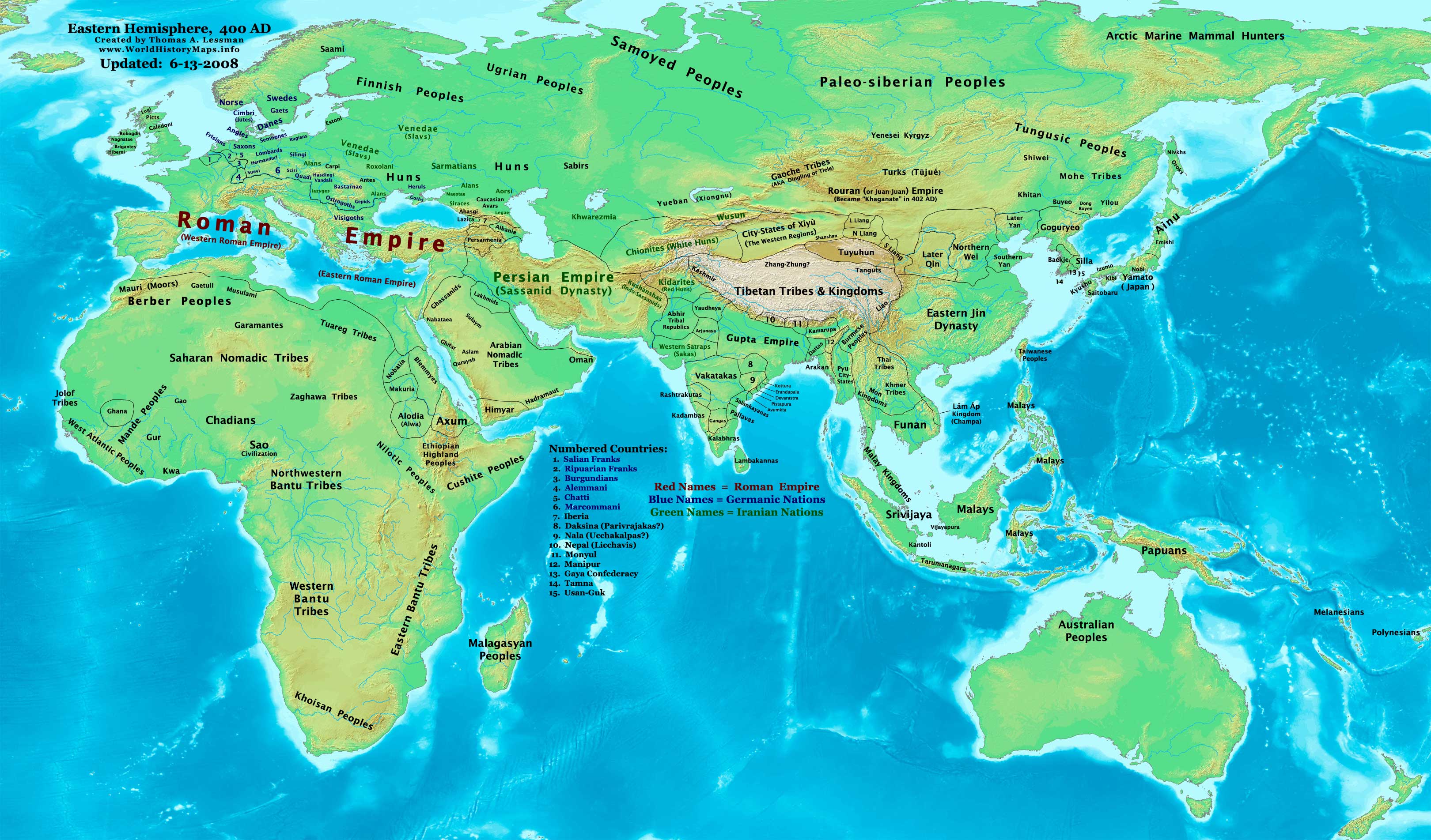
English: Eastern Hemisphere in 400 AD |
| 출처 | self-made (For reference information, see the Map Source References section below.) |
| 저자 | Thomas Lessman (Contact!) |
| 저작권 (이 파일을 인용하기) |
나는 아래 작품의 저작권자로서, 이 저작물을 다음과 같은 라이선스로 배포합니다: 이 파일은 크리에이티브 커먼즈 저작자표시-동일조건변경허락 3.0 Unported 라이선스로 배포됩니다.
|
| 다른 버전 | see East-Hem_400ad.jpg file history on Wikipedia. |
.jpg)
Map Summary
Original Source URL: http://www.thomaslessman.com/History/images/East-Hem_400ad.jpg.
This map of the Eastern Hemisphere in 400 AD was created by Thomas Lessman, based on information from the sources listed below. This map is free for educational use (see Permission info above). When using this map, please mention that it is available for free at www.WorldHistoryMaps.info.
Map Source References
- Remember, sources often conflict with each other. This map is only as accurate as the information that is available to me. To report any errors or to help further this work, please click here, or email Thomas Lessman at talessman@yis.us
Source References for information contained in this map:
Primary Sources for East-Hem_400ad.jpg:
- 1. The DK Atlas of World History, 2000 Edition (See specific references below).
- 2. WorldHistoryMaps.com's maps of the Countries of the World, 1-1-386 archive copy at the Wayback Machine.
- 3. Wikimedia's World Map 400 CE, made by User:Javierfv1212, and Wikipedia articles (noted below).
I - African Information
Note: Most of the African Information I have for 400 AD comes from The DK Atlas of World History map of The Development of Complex Societies in Africa; (Pg 160).
- (Bantus, Berber Tribes, Chadians, Cushites, Daamat, Garamantes, Gur, Khoisan Peoples, Kwa, Libyans, Mandes, Nilotic Peoples, West Atlantic Peoples)
II - Asian Information is derived from these sources:
- Arabian Tribal Locations are derived from this map of 5th century Arabia, from www.MidEastWeb.org.
- Caucasian borders are from the map of Europe in 400 AD on Euratlas.com.
- (Albania, Iberia, Lazica, and Persarmenia, etc.)
- China's Eastern Jin Dynasty borders are derived from:
- 1. The DK Atlas of World History map of The Later 16 Kingdoms period, c. 400 CE, (Pg 261)
- 2. The WorldHistoryMaps.com map of the Countries of the World, 1-1-386 archive copy at the Wayback Machine.
- Funan borders are derived from:
- 1. The DK Atlas of World History, 2000 Edition; map of The World in 250 CE, (Pg 46-47).
- 2. Wikipedia's article about Funan, along with this map of Funan in 001, uploaded by User:L_joo.
- Indian Information is derived from:
- 1. Comparison of WorldHistoryMaps.com's maps of the Countries of the World in 386 archive copy at the Wayback Machine and 420 CE. (Note: The 386 map is available for free on their sample page. The 420 CE map is available only to paid accounts.)
- 2. This map of Gupta Expansion[dead link], from "The World: Grand Atlas of History" by SA Ebisa, put online by the Imperial Maps archive copy at the Wayback Machine website (in Spanish).
- 3. Any information missing from the maps listed above is covered in Wikipedia articles on the countries depicted.
- Japanese information is derived from the DK Atlas of World History, 2000 Edition; map of State Formation in Korea & Japan to 650 CE; (Pg 264)
- Kidarite and Kushansha borders are derived from the WorldHistoryMaps.com map of the Countries of the World in 386 CE archive copy at the Wayback Machine. (Note: These maps show Kidarites as Kingdom of Gandhara and Taxila.)
- Korean and Manchurian information comes from this map of the History_of_Korea-375.png, created by User:Historiographer.
- Malay Kingdoms and peoples are derived from The DK Atlas of World History, 2000 Edition; map of "Areas influenced by India in SE Asia to 650 CE"; (Pg 241)
- Rouran or Juan-Juan information is from the History & Commercial Atlas of China, map of Asia in 440 AD, available on Huhai.net, along with Wikipedia's article about the Rouran and its first two Khagans.
- Sassanid Persian Empire borders are derived from:
- 1. Eastern Sassanid borders are based on the WorldHistoryMaps.com map of the Countries of the World in 386 CE archive copy at the Wayback Machine.
- 2. Western Sassanid borders are based on the Euratlas.com map of Europe in 400 AD.
- Turks, Yueban, & Gaoche locations come from:
- 1. The History & Commercial Atlas of China, map of Asia in 440 AD, available on Huhai.net.
- 2. Wikipedia's articles about the Yueban state, the Dingling (aka Gaoche), and the Göktürks.
III - European Information is mostly derived from the Euratlas.com map of Europe in 400 AD.
IV - Australia, Siberia, & Other Fringe Information is derived from:
- 1. Wikimedia's map of the World Map 400 CE, made by User:Javierfv1212.
- 2. Comparison of The DK Atlas of World History maps of The World in 250 CE (Pg 47) and The World in 500 CE (Pg 51).
Note: Much of the information in this map was cross-checked with Bruce Gordon's Regnal Chronologies
Other Maps by Thomas Lessman
| Maps of the eastern hemisphere showing history
Bold dates are available on Wikimedia or Wikipedia. | ||
| Primeval | ||
| Ancient
|
·| 600 BC | 550 BC | 527 BC | 500 BC |
400 BC | ·| 1 AD | 50 AD | 100 AD | 200 AD | 300 AD | | |
| Medieval |
·| 500 AD | 565 AD | 600 AD | 700 AD | | |
| Modern |
·| 1500 AD | · * For historical maps of the whole world, | |
기존 올리기 기록
- 2008-02-01 23:57 Talessman 3240×1903×8 (738603 bytes) Corrected borders of North China, southeast Asia, India, added more info for Siberia and Africa.
- 2007-12-25 01:31 Talessman 3240×1903×8 (729008 bytes) Corrected borders in central Asia and India, more info for Korea, etc.
- 2007-11-21 21:34 Talessman 3240×1903×8 (718510 bytes) Reverted to version as of 01:11, 19 November 2007 (Somehow I uploaded wrong version...)
- 2007-11-21 21:34 Talessman 3240×1903×8 (718510 bytes) Reverted to version as of 01:11, 19 November 2007 (Somehow I uploaded wrong version...)
- 2007-11-19 18:53 Talessman 3240×1903×8 (718510 bytes) Corrected minor spelling errors, added info for areas that were missing from previous version.
- 2007-11-19 01:11 Talessman 3240×1903×8 (718510 bytes) Updated information on fringe peoples, fixed Jin/Pyu/Tibetan borders, fixed Makuria/Nobatia/Alodia/Blemmyes borders, fixed Arabian borders, added Nepal.
- 2007-10-30 00:11 Talessman 3240×1903×8 (695017 bytes) Added updated info for Far Eastern regions
- 2007-10-01 22:17 Talessman 2880×1692×8 (550413 bytes) Author: Thomas A. Lessman. Source URL: http://www.ThomasLessman.com/History/images/East-Hem_400ad.jpg. Image was created by me (Thomas Lessman) based on historical information located on Wikipedia, as well as information from maps located in Wikipedia and
- 2007-09-12 21:47 Talessman 2880×1692×8 (533817 bytes) Author: Thomas A. Lessman. Source URL: http://www.ThomasLessman.com/History/images/East-Hem_400ad.jpg. Image was created by me (Thomas Lessman) based on historical information located on Wikipedia, as well as information from maps located in Wikipedia and
| 주석 | 이 이미지에는 주석이 있습니다: 공용에서 주석을 보기 |
파일 역사
날짜/시간 링크를 클릭하면 해당 시간의 파일을 볼 수 있습니다.
| 날짜/시간 | 섬네일 | 크기 | 사용자 | 설명 | |
|---|---|---|---|---|---|
| 현재 | 2008년 6월 14일 (토) 09:02 | | 3,240 × 1,903 (749 KB) | Talessman | {{Information |Description= |Source= |Date= |Author= |Permission= |other_versions= }} |
| 2008년 6월 14일 (토) 09:00 |  | 3,240 × 1,903 (749 KB) | Talessman | ||
| 2008년 5월 10일 (토) 02:07 |  | 3,240 × 1,903 (740 KB) | Talessman | {{Information |Description=Eastern Hemisphere in 400 AD. |Source=self-made |Author=User:Talessman |Permission={{self|cc-by-sa-3.0}} }} |
이 파일을 사용하는 문서
다음 문서 1개가 이 파일을 사용하고 있습니다:
이 파일을 사용하고 있는 모든 위키의 문서 목록
다음 위키에서 이 파일을 사용하고 있습니다:
- arz.wikipedia.org에서 이 파일을 사용하고 있는 문서 목록
- be.wikipedia.org에서 이 파일을 사용하고 있는 문서 목록
- bs.wikipedia.org에서 이 파일을 사용하고 있는 문서 목록
- da.wikipedia.org에서 이 파일을 사용하고 있는 문서 목록
- en.wikipedia.org에서 이 파일을 사용하고 있는 문서 목록
- es.wikipedia.org에서 이 파일을 사용하고 있는 문서 목록
- fi.wikipedia.org에서 이 파일을 사용하고 있는 문서 목록
- frr.wikipedia.org에서 이 파일을 사용하고 있는 문서 목록
- gl.wikipedia.org에서 이 파일을 사용하고 있는 문서 목록
- hu.wikipedia.org에서 이 파일을 사용하고 있는 문서 목록
- lt.wikipedia.org에서 이 파일을 사용하고 있는 문서 목록
- mk.wikipedia.org에서 이 파일을 사용하고 있는 문서 목록
- my.wikipedia.org에서 이 파일을 사용하고 있는 문서 목록
- pl.wikipedia.org에서 이 파일을 사용하고 있는 문서 목록
- rue.wikipedia.org에서 이 파일을 사용하고 있는 문서 목록
- ru.wikipedia.org에서 이 파일을 사용하고 있는 문서 목록
- shn.wikipedia.org에서 이 파일을 사용하고 있는 문서 목록
- sh.wikipedia.org에서 이 파일을 사용하고 있는 문서 목록
- sv.wikipedia.org에서 이 파일을 사용하고 있는 문서 목록
- sw.wikipedia.org에서 이 파일을 사용하고 있는 문서 목록
- ta.wikipedia.org에서 이 파일을 사용하고 있는 문서 목록
- tl.wikipedia.org에서 이 파일을 사용하고 있는 문서 목록
- vi.wikipedia.org에서 이 파일을 사용하고 있는 문서 목록