파일:East Prussia 1923-1939 map-fr.svg

SVG 파일의 PNG 형식의 미리보기 크기: 651 × 600 픽셀. 다른 해상도: 261 × 240 픽셀 | 521 × 480 픽셀 | 834 × 768 픽셀 | 1,111 × 1,024 픽셀 | 2,223 × 2,048 픽셀 | 865 × 797 픽셀
원본 파일 (SVG 파일, 실제 크기 865 × 797 픽셀, 파일 크기: 234 KB)
파일 설명
| 설명 |
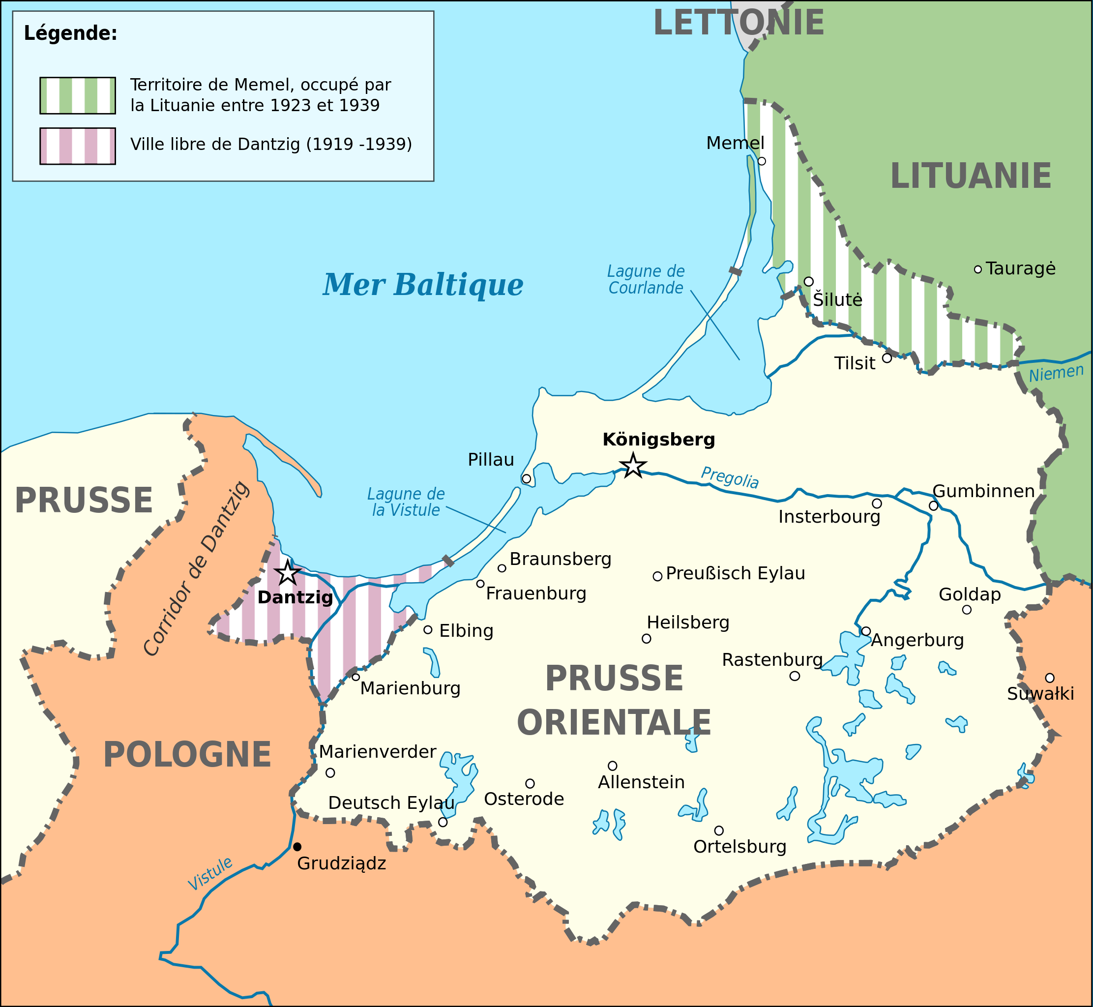
Deutsch: Karte von Ostpreußen 1923-1939. English: Map of Germany's province of East Prussia from 1923 to 1939, with Memelland occupied by Lithuania since 1923. Français : Carte de la province allemande de Prusse-Orientale entre 1923 et 1939, montrant la zone de Memel occupée par la Lituanie depuis 1923. Magyar: Kelet-Poroszország térképe 1923-1939 között. |
||||
| 날짜 | (UTC) | ||||
| 출처 |
이 파일은 다음에 의해 파생됨: East Prussia 1939.JPG:  |
||||
| 저자 |
|
||||
| 다른 버전 |
[]
| ||||
| SVG | W3C-validity not checked.
|
||||
| Graphic Lab |


| 대상 위치 | | 이 지역의 다른 사진을 보기: OpenStreetMap |
|---|
라이선스
나는 아래 작품의 저작권자로서, 이 저작물을 다음과 같은 라이선스로 배포합니다:
이 파일은 크리에이티브 커먼즈 저작자표시-동일조건변경허락 3.0 Unported 라이선스로 배포됩니다.
- 이용자는 다음의 권리를 갖습니다:
- 공유 및 이용 – 저작물의 복제, 배포, 전시, 공연 및 공중송신
- 재창작 – 저작물의 개작, 수정, 2차적저작물 창작
- 다음과 같은 조건을 따라야 합니다:
- 저작자표시 – 적절한 저작자 표시를 제공하고, 라이센스에 대한 링크를 제공하고, 변경사항이 있는지를 표시해야 합니다. 당신은 합리적인 방식으로 표시할 수 있지만, 어떤 방식으로든 사용권 허가자가 당신 또는 당신의 사용을 지지하는 방식으로 표시할 수 없습니다.
- 동일조건변경허락 – 만약 당신이 이 저작물을 리믹스 또는 변형하거나 이 저작물을 기반으로 제작하는 경우, 당신은 당신의 기여물을 원저작물과 동일하거나 호환 가능한 라이선스에 따라 배포하여야 합니다.
기존 올리기 기록
This image is a derivative work of the following images:
- File:East_Prussia_1939.JPG licensed with Cc-by-sa-3.0-migrated, GFDL
- 2008-03-24T22:23:30Z Renata3 752x808 (95143 Bytes) did not crop properly
- 2008-03-24T20:41:51Z Renata3 824x818 (96055 Bytes) cropped white space
- 2006-12-22T22:30:28Z Electionworld 824x818 (303157 Bytes) {{ew|en|Schwartz und Weiss}} East Prussia 1939 {{GFDL}} [[Category:Maps of East Prussia]] [[Category:Maps of the history of Poland]] [[Category:Maps of the history of Russia]] [[Category:Maps of the history of Germany]] [[Cat
Uploaded with derivativeFX
파일 역사
날짜/시간 링크를 클릭하면 해당 시간의 파일을 볼 수 있습니다.
| 날짜/시간 | 섬네일 | 크기 | 사용자 | 설명 | |
|---|---|---|---|---|---|
| 현재 | 2024년 5월 3일 (금) 11:03 | | 865 × 797 (234 KB) | BlackShadowG | File uploaded using svgtranslate tool (https://svgtranslate.toolforge.org/). Added translation for zh-hans. |
| 2022년 10월 14일 (금) 05:09 |  | 865 × 797 (202 KB) | Ispanas | File uploaded using svgtranslate tool (https://svgtranslate.toolforge.org/). Added translation for lt. | |
| 2020년 6월 13일 (토) 22:53 |  | 865 × 797 (170 KB) | Nk | File uploaded using svgtranslate tool (https://svgtranslate.toolforge.org/). Added translation for bg. | |
| 2020년 4월 17일 (금) 18:53 |  | 865 × 797 (127 KB) | Flappiefh | Baltiisk was named Pillau before 1946. | |
| 2014년 5월 26일 (월) 22:12 |  | 865 × 797 (127 KB) | Sémhur | Valid SVG | |
| 2012년 9월 4일 (화) 23:40 |  | 865 × 797 (127 KB) | Sémhur | == {{int:filedesc}} == {{Information |Description={{Multilingual description |en= Map of Germany's province of en:East Prussia from 1923 to 1939, with Memelland occupied by Lithuania since 1923 |fr= Carte de la province allemande de [[:fr:Prusse-... |
이 파일을 사용하는 문서
다음 문서 2개가 이 파일을 사용하고 있습니다:
이 파일을 사용하고 있는 모든 위키의 문서 목록
다음 위키에서 이 파일을 사용하고 있습니다:
- bg.wikipedia.org에서 이 파일을 사용하고 있는 문서 목록
- fr.wikipedia.org에서 이 파일을 사용하고 있는 문서 목록
- lt.wikipedia.org에서 이 파일을 사용하고 있는 문서 목록
- www.wikidata.org에서 이 파일을 사용하고 있는 문서 목록