파일:Europe 814.png

미리 보기 크기: 777 × 600 픽셀 다른 해상도: 311 × 240 픽셀 | 622 × 480 픽셀 | 995 × 768 픽셀 | 1,280 × 988 픽셀 | 1,393 × 1,075 픽셀
원본 파일 (1,393 × 1,075 픽셀, 파일 크기: 169 KB, MIME 종류: image/png)

파일 설명
| 설명 |
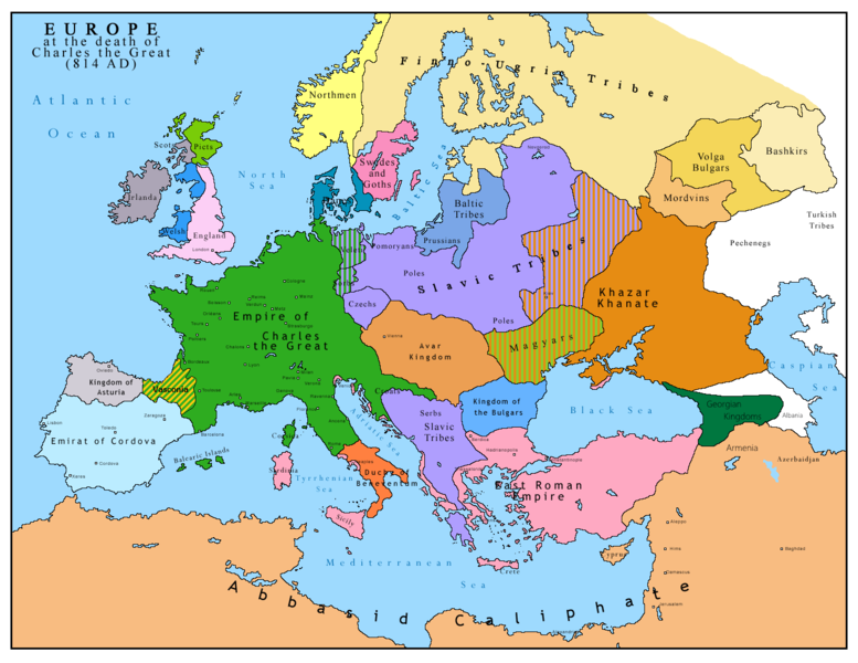
English: Map of Europe after the death of Charles the Great (814 AD). Original map made by Charles Colbeck, The Public Schools Historical Atlas (1905). |
|||
| 날짜 | 2009-04-15. Source date: 1905 by Longmans, Green; New York, London, Bombay 1905. | |||
| 출처 | 다음을 기초로 한 자작: Europe 814.jpg | |||
| 저자 | Bukkia (토론 · 기여) | |||
| 다른 버전 |
|


라이선스
| 나는 이 작품의 저작권자로서, 이 작품을 퍼블릭 도메인으로 모두에게 공개합니다. 이 공개 선언은 전 세계적으로 유효합니다. 만약 저작권의 포기가 법률적으로 가능하지 않은 경우, 나는 이 작품을 법적으로 허용되는 한도 내에서 누구나 자유롭게 어떤 목적으로도 제한없이 사용할 수 있도록 허용합니다. |
_en.png)
.png)
.jpg)
파일 역사
날짜/시간 링크를 클릭하면 해당 시간의 파일을 볼 수 있습니다.
| 날짜/시간 | 섬네일 | 크기 | 사용자 | 설명 | |
|---|---|---|---|---|---|
| 현재 | 2023년 4월 26일 (수) 20:09 | | 1,393 × 1,075 (169 KB) | OrionNimrod | Reverted to version as of 13:52, 23 December 2015 (UTC) restore |
| 2019년 5월 3일 (금) 01:09 |  | 1,370 × 1,047 (124 KB) | Julieta39 | Slavs also in the Avars and Bulgars kingdoms | |
| 2015년 12월 23일 (수) 22:52 |  | 1,393 × 1,075 (169 KB) | Ercwlff | at that time armenia was already part of Arab caliphate.. and there were several Georgian kingdoms or principalities in the north of them | |
| 2015년 6월 8일 (월) 22:52 |  | 1,393 × 1,075 (157 KB) | Zorion | Vasconia in rebellion | |
| 2015년 5월 29일 (금) 02:49 |  | 1,393 × 1,075 (156 KB) | Zorion | From 812 to 824, Vasconia was ruled by Vascons (sourced can be found anywhere in spanish, basque or french). This map was wrong for that specific year. Seems that historian wanted to credit a famous king but, he was dead when Wasconia got back under th... | |
| 2014년 8월 25일 (월) 00:58 |  | 1,393 × 1,075 (230 KB) | Martin H. | Reverted to version as of 14:53, 31 January 2010: File is consistent with its source file File:Europe 814.jpg; change conflicts with en:Duchy_of_Vasconia#Carolingian duchy (769–864) | |
| 2014년 8월 24일 (일) 23:42 |  | 1,393 × 1,075 (156 KB) | Zorion | Vasconia was independant from frankish kingdom until 824 | |
| 2010년 1월 31일 (일) 23:53 |  | 1,393 × 1,075 (230 KB) | Bukkia | == {{int:filedesc}} == {{Information |Description={{it|1=Mappa dell'Europa alla morte di Carlo Magno (814 d.C.)}} {{en|1=Map of Europe after the death of Charles the Great (814 AD, in Italian)}} |Source=Based on File:Europe 814.jpg |Author=[[user:Buk |
이 파일을 사용하는 문서
다음 문서 1개가 이 파일을 사용하고 있습니다:
이 파일을 사용하고 있는 모든 위키의 문서 목록
다음 위키에서 이 파일을 사용하고 있습니다:
- arz.wikipedia.org에서 이 파일을 사용하고 있는 문서 목록
- bo.wikipedia.org에서 이 파일을 사용하고 있는 문서 목록
- da.wikipedia.org에서 이 파일을 사용하고 있는 문서 목록
- de.wikipedia.org에서 이 파일을 사용하고 있는 문서 목록
- el.wikipedia.org에서 이 파일을 사용하고 있는 문서 목록
- en.wikipedia.org에서 이 파일을 사용하고 있는 문서 목록
- es.wikipedia.org에서 이 파일을 사용하고 있는 문서 목록
- fa.wikipedia.org에서 이 파일을 사용하고 있는 문서 목록
- fr.wikipedia.org에서 이 파일을 사용하고 있는 문서 목록
- gl.wikipedia.org에서 이 파일을 사용하고 있는 문서 목록
- he.wikipedia.org에서 이 파일을 사용하고 있는 문서 목록
- hu.wikipedia.org에서 이 파일을 사용하고 있는 문서 목록
- hy.wikipedia.org에서 이 파일을 사용하고 있는 문서 목록
- id.wikipedia.org에서 이 파일을 사용하고 있는 문서 목록
- it.wikipedia.org에서 이 파일을 사용하고 있는 문서 목록
- lmo.wikipedia.org에서 이 파일을 사용하고 있는 문서 목록
- lv.wikipedia.org에서 이 파일을 사용하고 있는 문서 목록
- mk.wikipedia.org에서 이 파일을 사용하고 있는 문서 목록
- pl.wikipedia.org에서 이 파일을 사용하고 있는 문서 목록
- ro.wikipedia.org에서 이 파일을 사용하고 있는 문서 목록
- sh.wikipedia.org에서 이 파일을 사용하고 있는 문서 목록
- sr.wikipedia.org에서 이 파일을 사용하고 있는 문서 목록
- sw.wikipedia.org에서 이 파일을 사용하고 있는 문서 목록
- uk.wikipedia.org에서 이 파일을 사용하고 있는 문서 목록