파일:Falkland Islands topographic map-en.svg
원본 파일(SVG 파일, 실제 크기 2,550 × 1,990 픽셀, 파일 크기: 1.97 MB)

 
  This SVG map uses required raster graphics to show delicate structures.
모습 of the year
모습 of the year
Featured 모습

위키미디어 공용위키백과

이 파일은 2007년 올해의 이미지에서 후보로 선정되었습니다.
이 파일은 위키미디어 공용 (알찬 그림)에서 알찬 이미지였으며 최우수 이미지 중 하나로 여겨집니다.

 이 파일은 영어 위키백과 (Featured pictures)에서 알찬 이미지였으며 최우수 이미지 중 하나로 여겨집니다.

비슷한 품질의 이미지를 알맞은 라이선스로 배포할 수 있다면, 파일을 올린 후에 저작권 태그를 붙여서 후보로 등록 해주세요.


Pour agrandir l'image

Detailed map of large dimension. For a better viewing, click on the link of the image above.
Carte détaillée de grande dimension. Pour une visualisation optimale, cliquer sur le lien de l'image ci-dessus.

파일 설명

묘사
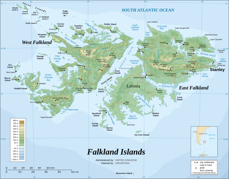
English: The Falkland Islands are an archipelago in the South Atlantic Ocean, located 300 miles off the coast of Argentina. They consist of two main islands, East Falkland and West Falkland, together with about 700 smaller islands. Stanley, on East Falkland, is the capital and largest city. The islands are a self-governing Overseas Territory of the United Kingdom.
Français : Carte topographique en anglais des Îles Malouines. Les Malouines forment un archipel dans l'Océan Atlantique Sud à 480 km des côtes argentines. Il est composé de deux îles principales, East Falkland et West Falkland, et de 700 autres îles et îlots. Stanley, sur East Falkland, est la capitale et la plus grande agglomération de l'archipel. Les Malouines sont un territoire autonome du Royaume-Uni.
Nederlands: Topografische kaart van de Falklandeilanden, een Brits overzees gebiedsdeel in de Zuidelijke Atlantische Oceaan. De archipel bestaat uit twee hoofdeilanden en ongeveer 700 kleinere op ongeveer 300 kilometer uit de kust van Argentinië. Stanley op het eiland 'East Falkland' is de hoofdstad en tergelijkertijd de meest bevolkte gemeente van het eilandengroep.De eilanden zijn een 'self-governing Overseas Territory' van het Verenigd Koninkrijk van Groot-Brittannië en Noord-Ierland.
Português: Mapa topográfico (em inglês) das Ilhas Malvinas, um arquipélago no sul do Oceano Atlântico, a 300 milhas da costa da Argentina. Consiste de duas ilhas, Soledad a leste e Gran Malvina, a oeste, junto com cerca de 700 outras ilhotas. A capital (e maior cidade) é Stanley. As Malvinas são um território autónomo do Reino Unido.
SVG 발전
InfoField
 
SVG 파일의 소스 코드 문법이 올바릅니다.
 
벡터 그림Inkscape(으)로 제작되었습니다.
{| cellspacing="8" cellpadding="0" style="clear:both; width:100%; margin:0.5em auto; border:2px solid #88A; background-color:#F7F8FF;" lang="ko" dir="ltr"

|align="center"|이 파일을 번역

|width="100%"|

이 SVG 파일은 편집 가능한 문자를 사용하므로 Inkscape나 Adobe Illustrator를 사용하여 쉽게 다른 언어로 번역할 수 있습니다. 여기를 참고하세요.

또한 텍스트 편집기를 이용하여 수동으로 파일을 번역할 수도 있습니다.

|}
날짜 November 2007 using elements from the original version of April 2007
출처 Own work ;
Topographic map : NASA Shuttle Radar Topography Mission (SRTM3 v.2) (public domain) edited with dlgv32 Pro/Global Mapper and vectorized with Inkscape ; UTM projection ; WGS84 datum ; shaded relief (composite image of N-W, W and N lightning positions) ;
Approximate scale of topographic data and shore / lakes limits : 1:705,000 ; of the bathymetry : 1:3.720.000
Bathymetry : USGov public domain data provided by the Demis add-on for World Wind (see the approval e-mail) ;
Other references used for additional data :
* UK government map ;
* NASA World Wind ;
* CIA map available on the site of the University of Texas at Austin ;
* Microsoft Encarta atlas (1999 edition).
Note : The shaded relief is a raster image embedded in the SVG file which increases its size. If you want a lighter map for other purposes, delete the shaded relief image in your file.
창작자
Eric Gaba (Sting - fr:Sting)
저작권
(이 파일을 인용하기)
Attribution and Share-Alike required
지리 참고 Wikimaps Warper에서 지도 지리를 참고하기 부적절한 경우에 숨기려면 warp_status = skip로 설정하세요.
다른 버전

이 파일은 다음으로 파생됨:

[편집]


라이선스

나는 아래 작품의 저작권자로서, 이 저작물을 다음과 같은 라이선스로 배포합니다:
GNU head GNU 자유 문서 사용 허가서 1.2판 또는 자유 소프트웨어 재단에서 발행한 이후 판의 규정에 따라 본 문서를 복제하거나 개작 및 배포할 수 있습니다. 본 문서에는 변경 불가 부분이 없으며, 앞 표지 구절과 뒷 표지 구절도 없습니다. 본 사용 허가서의 전체 내용은 GNU 자유 문서 사용 허가서 부분에 포함되어 있습니다.
w:ko:크리에이티브 커먼즈
저작자표시 동일조건변경허락
이 파일은 크리에이티브 커먼즈 저작자표시-동일조건변경허락 3.0 Unported 라이선스로 배포됩니다.
이용자는 다음의 권리를 갖습니다:
  • 공유 및 이용 – 저작물의 복제, 배포, 전시, 공연 및 공중송신
  • 재창작 – 저작물의 개작, 수정, 2차적저작물 창작
다음과 같은 조건을 따라야 합니다:
  • 저작자표시 – 적절한 저작자 표시를 제공하고, 라이센스에 대한 링크를 제공하고, 변경사항이 있는지를 표시해야 합니다. 당신은 합리적인 방식으로 표시할 수 있지만, 어떤 방식으로든 사용권 허가자가 당신 또는 당신의 사용을 지지하는 방식으로 표시할 수 없습니다.
  • 동일조건변경허락 – 만약 당신이 이 저작물을 리믹스 또는 변형하거나 이 저작물을 기반으로 제작하는 경우, 당신은 당신의 기여물을 원저작물과 동일하거나 호환 가능한 라이선스에 따라 배포하여야 합니다.
이 라이선스 틀은 GFDL 라이선스 변경의 일부로 이 파일에 추가되었습니다.
w:ko:크리에이티브 커먼즈
저작자표시 동일조건변경허락
이 파일은 크리에이티브 커먼즈 저작자표시-동일조건변경허락 2.5, 2.0 그리고 1.0 라이선스로 배포됩니다.
이용자는 다음의 권리를 갖습니다:
  • 공유 및 이용 – 저작물의 복제, 배포, 전시, 공연 및 공중송신
  • 재창작 – 저작물의 개작, 수정, 2차적저작물 창작
다음과 같은 조건을 따라야 합니다:
  • 저작자표시 – 적절한 저작자 표시를 제공하고, 라이센스에 대한 링크를 제공하고, 변경사항이 있는지를 표시해야 합니다. 당신은 합리적인 방식으로 표시할 수 있지만, 어떤 방식으로든 사용권 허가자가 당신 또는 당신의 사용을 지지하는 방식으로 표시할 수 없습니다.
  • 동일조건변경허락 – 만약 당신이 이 저작물을 리믹스 또는 변형하거나 이 저작물을 기반으로 제작하는 경우, 당신은 당신의 기여물을 원저작물과 동일하거나 호환 가능한 라이선스에 따라 배포하여야 합니다.
이 라이선스 중에서 목적에 맞는 것을 선택하여 사용할 수 있습니다.

설명

이 파일이 나타내는 바에 대한 한 줄 설명을 추가합니다

이 파일에 묘사된 항목

다음을 묘사함

image/svg+xml

파일 역사

날짜/시간 링크를 클릭하면 해당 시간의 파일을 볼 수 있습니다.

(최신 | 오래됨) (다음 10개 | ) (10 | 20 | 50 | 100 | 250 | 500) 보기
날짜/시간섬네일크기사용자설명
현재2021년 8월 23일 (월) 11:512021년 8월 23일 (월) 11:51 판의 섬네일2,550 × 1,990 (1.97 MB)Praça de MaioFile uploaded using svgtranslate tool (https://svgtranslate.toolforge.org/). Added translation for tr.
2021년 8월 23일 (월) 11:502021년 8월 23일 (월) 11:50 판의 섬네일2,550 × 1,990 (1.97 MB)Praça de MaioFile uploaded using svgtranslate tool (https://svgtranslate.toolforge.org/). Added translation for tr.
2017년 4월 6일 (목) 20:542017년 4월 6일 (목) 20:54 판의 섬네일2,550 × 1,990 (1.91 MB)RaviC+ New Haven Ferry
2008년 12월 20일 (토) 03:382008년 12월 20일 (토) 03:38 판의 섬네일2,550 × 1,990 (1.93 MB)StingReverted to version as of 03:38, 14 November 2007: please upload the translated version under a specific name
2008년 12월 20일 (토) 03:262008년 12월 20일 (토) 03:26 판의 섬네일2,550 × 1,990 (1.93 MB)Vitekthis is just croatian translation
2007년 11월 14일 (수) 12:382007년 11월 14일 (수) 12:38 판의 섬네일2,550 × 1,990 (1.93 MB)StingNew version more accurate and with shaded relief
2007년 6월 16일 (토) 10:182007년 6월 16일 (토) 10:18 판의 섬네일2,550 × 1,990 (1.03 MB)StingReverted to earlier revision
2007년 6월 16일 (토) 10:032007년 6월 16일 (토) 10:03 판의 섬네일2,550 × 1,990 (2.14 MB)StingTrying to fix the bug on WP-en #8
2007년 6월 16일 (토) 09:402007년 6월 16일 (토) 09:40 판의 섬네일2,550 × 1,990 (2.01 MB)StingTrying to fix the bug on WP-en #7 (really boring...)
2007년 6월 16일 (토) 09:292007년 6월 16일 (토) 09:29 판의 섬네일2,550 × 1,990 (2.08 MB)StingTrying to fix the bug on WP-en #6 (OK, the problem comes from the shaded relief raster image)
(최신 | 오래됨) (다음 10개 | ) (10 | 20 | 50 | 100 | 250 | 500) 보기

다음 문서 2개가 이 파일을 사용하고 있습니다:

이 파일을 사용하고 있는 모든 위키의 문서 목록

다음 위키에서 이 파일을 사용하고 있습니다:

이 파일의 더 많은 사용 내역을 봅니다.

메타데이터