파일:Galunggung.jpg
미리 보기 크기: 800 × 534 픽셀 다른 해상도: 320 × 213 픽셀 | 640 × 427 픽셀 | 1,000 × 667 픽셀
원본 파일 (1,000 × 667 픽셀, 파일 크기: 203 KB, MIME 종류: image/jpeg)
파일 설명
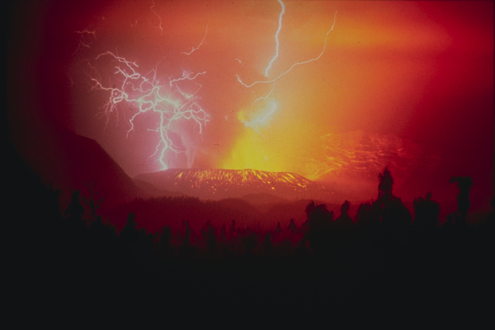
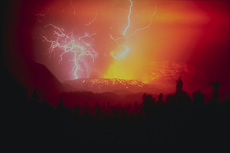
| 설명 | United States Geological Survey photo of 1982 eruption of Galungung (with lightning strikes). Cropped. This stratovolcano with a lava dome is located in western Java. Its first eruption in 1822 produced a 22-km-long mudflow that killed 4,000 people. The second eruption in 1894 caused extensive property loss. The slide depicts a spectacular view of lightning strikes during a third eruption on December 3, 1982, which resulted in 68 deaths. A fourth eruption occurred in 1984. Source Caption: Galunggung, Indonesia;07.25 S 108.05 E;2,168 m elevation |
| 날짜 | |
| 출처 | image from NOAA website |
| 저자 | R. Hadian, U.S. Geological Survey |
| 다른 버전 |

| 카메라 위치 | | 이 지역의 다른 사진을 보기: OpenStreetMap |
|---|
라이선스
|
|
파일 역사
날짜/시간 링크를 클릭하면 해당 시간의 파일을 볼 수 있습니다.
| 날짜/시간 | 섬네일 | 크기 | 사용자 | 설명 | |
|---|---|---|---|---|---|
| 현재 | 2023년 9월 8일 (금) 15:38 | | 1,000 × 667 (203 KB) | Hike395 | higher resolution from original tif |
| 2005년 5월 9일 (월) 14:46 |  | 960 × 530 (35 KB) | Hike395 | United States Geological Survey photo of 1982 eruption of Galungung (with lightning strikes). Cropped. {{PD-USGov-USGS}} Source URL: http://www.ngdc.noaa.gov/seg/hazard/img/200_res/30/30_603.tif Source Caption: Galunggung, Indonesia;07.25 S 108.05 E;2,1 |
이 파일을 사용하는 문서
이 파일을 사용하고 있는 모든 위키의 문서 목록
다음 위키에서 이 파일을 사용하고 있습니다:
- an.wikipedia.org에서 이 파일을 사용하고 있는 문서 목록
- ar.wikipedia.org에서 이 파일을 사용하고 있는 문서 목록
- arz.wikipedia.org에서 이 파일을 사용하고 있는 문서 목록
- ast.wikipedia.org에서 이 파일을 사용하고 있는 문서 목록
- as.wikipedia.org에서 이 파일을 사용하고 있는 문서 목록
- av.wikipedia.org에서 이 파일을 사용하고 있는 문서 목록
- ba.wikipedia.org에서 이 파일을 사용하고 있는 문서 목록
- beta.wikiversity.org에서 이 파일을 사용하고 있는 문서 목록
- bg.wikipedia.org에서 이 파일을 사용하고 있는 문서 목록
- bh.wikipedia.org에서 이 파일을 사용하고 있는 문서 목록
- br.wikipedia.org에서 이 파일을 사용하고 있는 문서 목록
- bs.wikipedia.org에서 이 파일을 사용하고 있는 문서 목록
- ca.wikipedia.org에서 이 파일을 사용하고 있는 문서 목록
- ceb.wikipedia.org에서 이 파일을 사용하고 있는 문서 목록
- ce.wikipedia.org에서 이 파일을 사용하고 있는 문서 목록
- cs.wikipedia.org에서 이 파일을 사용하고 있는 문서 목록
- da.wikipedia.org에서 이 파일을 사용하고 있는 문서 목록
- de.wikipedia.org에서 이 파일을 사용하고 있는 문서 목록
- en.wikipedia.org에서 이 파일을 사용하고 있는 문서 목록
- en.wikibooks.org에서 이 파일을 사용하고 있는 문서 목록
- en.wikiquote.org에서 이 파일을 사용하고 있는 문서 목록
- en.wikiversity.org에서 이 파일을 사용하고 있는 문서 목록
- es.wikipedia.org에서 이 파일을 사용하고 있는 문서 목록
- et.wikipedia.org에서 이 파일을 사용하고 있는 문서 목록
- eu.wikipedia.org에서 이 파일을 사용하고 있는 문서 목록
이 파일의 더 많은 사용 내역을 봅니다.