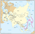
파일:Geographic Boundaries of the First and Second Island Chains.png

미리 보기 크기: 621 × 600 픽셀 다른 해상도: 248 × 240 픽셀 | 497 × 480 픽셀 | 795 × 768 픽셀 | 1,060 × 1,024 픽셀 | 1,387 × 1,340 픽셀
원본 파일 (1,387 × 1,340 픽셀, 파일 크기: 51 KB, MIME 종류: image/png)
파일 역사
날짜/시간 링크를 클릭하면 해당 시간의 파일을 볼 수 있습니다.
| 날짜/시간 | 섬네일 | 크기 | 사용자 | 설명 | |
|---|---|---|---|---|---|
| 현재 | 2018년 3월 8일 (목) 09:24 |  | 1,387 × 1,340 (51 KB) | Ras67 | new extracted and cropped from the PDF |
| 2016년 11월 7일 (월) 20:32 |  | 1,434 × 1,378 (104 KB) | Ricky22p | Better quality version extracted from the same PDF file using GNOME Document Viewer. | |
| 2006년 5월 26일 (금) 17:29 |  | 1,431 × 1,121 (89 KB) | Shizhao | {{Information |Description=Figure 2. Geographic Boundaries of the First and Second Island Chains |Source=Image:China Report 2006.pdf |Date=05/23/06 |Author=DoD |Permission={{PD-USGov-Military}} |other_versions= }} [[Category:Chinas' Military Power Re |
이 파일을 사용하는 문서
이 파일을 사용하고 있는 모든 위키의 문서 목록
다음 위키에서 이 파일을 사용하고 있습니다:
- ar.wikipedia.org에서 이 파일을 사용하고 있는 문서 목록
- de.wikipedia.org에서 이 파일을 사용하고 있는 문서 목록
- en.wikipedia.org에서 이 파일을 사용하고 있는 문서 목록
- fa.wikipedia.org에서 이 파일을 사용하고 있는 문서 목록
- fr.wikipedia.org에서 이 파일을 사용하고 있는 문서 목록
- id.wikipedia.org에서 이 파일을 사용하고 있는 문서 목록
- it.wikipedia.org에서 이 파일을 사용하고 있는 문서 목록
- ja.wikipedia.org에서 이 파일을 사용하고 있는 문서 목록
- no.wikipedia.org에서 이 파일을 사용하고 있는 문서 목록
- pt.wikipedia.org에서 이 파일을 사용하고 있는 문서 목록
- uk.wikipedia.org에서 이 파일을 사용하고 있는 문서 목록
- vi.wikipedia.org에서 이 파일을 사용하고 있는 문서 목록
- www.wikidata.org에서 이 파일을 사용하고 있는 문서 목록
- zh.wikipedia.org에서 이 파일을 사용하고 있는 문서 목록
