파일:German and Japanese spheres of influence at greatest extent World War II 1942.jpg

미리 보기 크기: 800 × 471 픽셀 다른 해상도: 320 × 188 픽셀 | 640 × 377 픽셀 | 877 × 516 픽셀
원본 파일 (877 × 516 픽셀, 파일 크기: 172 KB, MIME 종류: image/jpeg)

|
이 그림 파일은 벡터 SVG 형식으로 다시 만들어야 합니다. SVG의 장점에 대해서는 여기(영어)를 참고해 주십시오. 만약 이 그림의 SVG 버전이 이미 존재한다면 이 틀을 {{vector version available|새 파일 이름.svg}}으로 대체해 주십시오.
|


| 설명 |
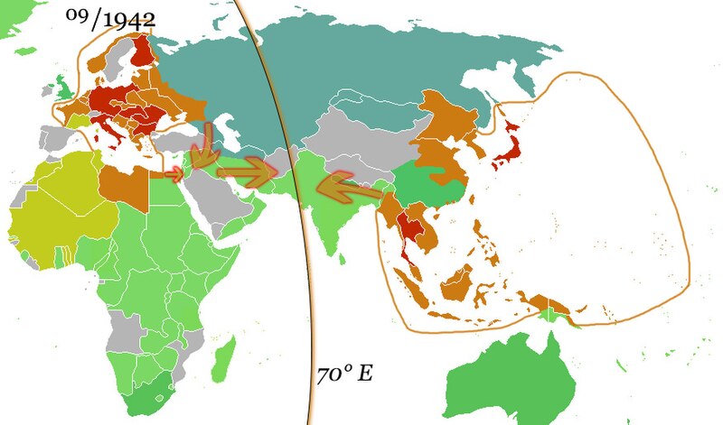
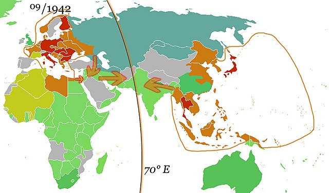
English: The German and the Japanese direct spheres of influence at their greatest extents during the Second World War in fall 1942. Arrows show planned movements to an agreed demarcation line at 70° E, which was, however, never even approximated.
The Allied countries.
Colonies, occupied territories and sphere of influence of the Allies.
The Axis countries.
Colonies, occupied territories and sphere of influence of the Axis
Vichy France and her remaining colonies.
The Soviet Union, its satellite states and sphere of influence.
Neutral countries. Deutsch: Die japanischen und deutschen direkten Einflusssphären während des zweiten Weltkrieges zum Zeitpunkt ihrer größten Ausdehnung im Herbst 1942. Pfeile zeigen geplante Bewegungen in Richtung einer vereinbarten Demarkationslinie entlang 70° östl. Länge, welche jedoch nie auch nur ansatzweise erreicht wurde.
Alliierte
Kolonien, besetzte Gebiete und Einflussbereiche der Alliierten
Achsenmächte
Kolonien, besetzte Gebiete und Einflussbereiche der Achse
Vichy-Frankreich und verbliebene Kolonien
Sowjetunion, ihre Satellitenstaaten und Einflussbereiche
Neutrale Staaten Русский: Немецкая и японская прямые сферы влияния достигли наибольшей степени во время Второй мировой войны осенью 1942 года. Стрелки показывают запланированные перемещения к согласованной демаркационной линии на 70° восточной долготы, которая, однако, никогда даже приблизительно не была определена.
Страны союзников.
Колонии, оккупированные территории и сферы влияния союзников.
Страны «Оси».
Колонии, оккупированные территории и сферы влияния стран Оси
Вишистская Франция и её оставшиеся колонии.
Советский Союз, его государства-сателлиты и сфера влияния.
Нейтральные страны. |
| 날짜 | (UTC) |
| 출처 | |
| 저자 |
|
| 이 그림은 수정된 그림으로, 원래 그림에서 디지털 변환이 이루어진 그림입니다. 수정 사항 : Added spheres of influence and 70° E.. 원래의 그림 : Ww2 allied axis.gif: File:Ww2 allied axis.gif. 수정판 제작자 36ophiuchi.
|
나는 아래 작품의 저작권자로서, 이 저작물을 다음과 같은 라이선스로 배포합니다:
| 이 파일은 크리에이티브 커먼즈 저작자표시-동일조건변경허락 3.0 Unported 라이선스로 배포됩니다. | ||
| ||
| 이 라이선스 틀은 GFDL 라이선스 변경의 일부로 이 파일에 추가되었습니다. |

|
GNU 자유 문서 사용 허가서 1.2판 또는 자유 소프트웨어 재단에서 발행한 이후 판의 규정에 따라 본 문서를 복제하거나 개작 및 배포할 수 있습니다. 본 문서에는 변경 불가 부분이 없으며, 앞 표지 구절과 뒷 표지 구절도 없습니다. 본 사용 허가서의 전체 내용은 GNU 자유 문서 사용 허가서 부분에 포함되어 있습니다. |
이 라이선스 중에서 목적에 맞는 것을 선택하여 사용할 수 있습니다.
기존 올리기 기록
This image is a derivative work of the following images:
- File:Ww2 allied axis.gif licensed with Cc-by-sa-3.0-migrated, GFDL
- 2010-04-07T22:14:13Z Hohum 1357x628 (106307 Bytes) Reverted to version as of 20:16, 25 November 2009 - problem is the wiki - not the image
- 2010-04-07T22:13:37Z Hohum 1357x628 (594030 Bytes) Reverted to version as of 17:47, 8 May 2009 - attempt to fix thumbnail
- 2009-11-25T20:16:27Z Bruce89 1357x628 (106307 Bytes) Optimised, some of it could be trimmed further
- 2009-05-08T17:47:59Z Rülpsmann 1357x628 (594030 Bytes) Reverted to version as of 08:29, 4 December 2006
- 2009-05-08T17:37:53Z Rülpsmann 1357x628 (594030 Bytes) less confusing, easier to understand if you think
- 2007-09-23T21:28:58Z Parhamr 1357x725 (272876 Bytes) this visual timeline communicates not only the dates but has some "visual context" of the time passed
- 2006-12-30T07:54:11Z Nxx 1357x628 (415308 Bytes) Reverted to earlier revision
- 2006-12-04T08:29:07Z Roke 1357x628 (594030 Bytes) use orange/green colours of original map
- 2006-05-19T04:36:35Z Roke 1357x628 (415308 Bytes) try version with sep 45 map, may not work as had problems
- 2006-05-18T20:04:37Z Roke 1357x628 (394879 Bytes) minor fix of some white lines in one frame
- 2006-05-18T19:38:30Z Roke 1357x628 (394934 Bytes) Western allies (blue), Soviet & allies (red) and Axis including Vichy French (black) during the [[w:Second World War|Second World War]]. Based on GNU image [[:Image:WWII.png]] [[Category:WWII maps (World)]] {{GFDL-self}}
Uploaded with derivativeFX
파일 역사
날짜/시간 링크를 클릭하면 해당 시간의 파일을 볼 수 있습니다.
| 날짜/시간 | 섬네일 | 크기 | 사용자 | 설명 | |
|---|---|---|---|---|---|
| 현재 | 2010년 10월 15일 (금) 19:05 | | 877 × 516 (172 KB) | 36ophiuchi~commonswiki | {{Information |Description={{en|The German and the Japanese direct spheres of influence at their greatest extents during the Second World War in fall 1942. Arrows show planned movements to an agreed demarcation line at 70° E, which was, however, never ev |
이 파일을 사용하는 문서
다음 문서 4개가 이 파일을 사용하고 있습니다:
이 파일을 사용하고 있는 모든 위키의 문서 목록
다음 위키에서 이 파일을 사용하고 있습니다:
- af.wikipedia.org에서 이 파일을 사용하고 있는 문서 목록
- ar.wikipedia.org에서 이 파일을 사용하고 있는 문서 목록
- arz.wikipedia.org에서 이 파일을 사용하고 있는 문서 목록
- be.wikipedia.org에서 이 파일을 사용하고 있는 문서 목록
- ca.wikipedia.org에서 이 파일을 사용하고 있는 문서 목록
- de.wikipedia.org에서 이 파일을 사용하고 있는 문서 목록
- el.wikipedia.org에서 이 파일을 사용하고 있는 문서 목록
- en.wikipedia.org에서 이 파일을 사용하고 있는 문서 목록
- es.wikipedia.org에서 이 파일을 사용하고 있는 문서 목록
- fa.wikipedia.org에서 이 파일을 사용하고 있는 문서 목록
- fr.wikipedia.org에서 이 파일을 사용하고 있는 문서 목록
- hy.wikipedia.org에서 이 파일을 사용하고 있는 문서 목록
- id.wikipedia.org에서 이 파일을 사용하고 있는 문서 목록
- it.wikipedia.org에서 이 파일을 사용하고 있는 문서 목록
- ja.wikipedia.org에서 이 파일을 사용하고 있는 문서 목록
- kk.wikipedia.org에서 이 파일을 사용하고 있는 문서 목록
- lv.wikipedia.org에서 이 파일을 사용하고 있는 문서 목록
- mk.wikipedia.org에서 이 파일을 사용하고 있는 문서 목록
- nds.wikipedia.org에서 이 파일을 사용하고 있는 문서 목록
- nl.wikipedia.org에서 이 파일을 사용하고 있는 문서 목록
- ru.wikipedia.org에서 이 파일을 사용하고 있는 문서 목록
- uk.wikipedia.org에서 이 파일을 사용하고 있는 문서 목록
- uz.wikipedia.org에서 이 파일을 사용하고 있는 문서 목록
- www.wikidata.org에서 이 파일을 사용하고 있는 문서 목록
- zh.wikipedia.org에서 이 파일을 사용하고 있는 문서 목록