파일:Gonâve microplate.png

미리 보기 크기: 800 × 506 픽셀 다른 해상도: 320 × 202 픽셀 | 640 × 405 픽셀 | 1,024 × 647 픽셀 | 1,280 × 809 픽셀 | 2,115 × 1,337 픽셀
원본 파일 (2,115 × 1,337 픽셀, 파일 크기: 1.3 MB, MIME 종류: image/png)
| 설명 |
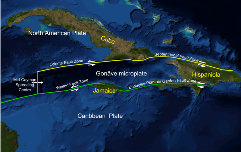
English: Screen shot from Nasa WorldWind software of NW Caribbean area |
| 날짜 | (UTC) |
| 출처 | |
| 저자 |
|
| 이 그림은 수정된 그림으로, 원래 그림에서 디지털 변환이 이루어진 그림입니다. 수정 사항 : Added plate boundaries and main faults, island names and plate names. 원래의 그림 : NWCaribbean satellite.png:
|
| This image is in the public domain because it is a screenshot from NASA’s globe software World Wind using a public domain layer, such as Blue Marble, MODIS, Landsat, SRTM, USGS or GLOBE.
|
 |
기존 올리기 기록
This image is a derivative work of the following images:
- File:NWCaribbean_satellite.png licensed with PD-WorldWind
- 2010-02-07T16:43:33Z Mikenorton 2111x1337 (1221182 Bytes) {{Information |Description={{en|1=Screen shot from Nasa WorldWind software of NW Caribbean area}} |Source=NASA WorldWind |Author=Mikenorton |Date=2010-02-07 |Permission={{PD-WorldWind}} |other_versions= }} [[Category:Satelli
Uploaded with derivativeFX
파일 역사
날짜/시간 링크를 클릭하면 해당 시간의 파일을 볼 수 있습니다.
| 날짜/시간 | 섬네일 | 크기 | 사용자 | 설명 | |
|---|---|---|---|---|---|
| 현재 | 2010년 2월 8일 (월) 01:50 | | 2,115 × 1,337 (1.3 MB) | Mikenorton | {{Information |Description={{en|1=Screen shot from Nasa WorldWind software of NW Caribbean area}} |Source=*File:NWCaribbean_satellite.png |Date=2010-02-07 16:49 (UTC) |Author=*File:NWCaribbean_satellite.png: Mikenorton *derivative work: ~~~ |P |
이 파일을 사용하는 문서
이 파일을 사용하고 있는 모든 위키의 문서 목록
다음 위키에서 이 파일을 사용하고 있습니다:
- bn.wikipedia.org에서 이 파일을 사용하고 있는 문서 목록
- ca.wikipedia.org에서 이 파일을 사용하고 있는 문서 목록
- cs.wikipedia.org에서 이 파일을 사용하고 있는 문서 목록
- de.wikipedia.org에서 이 파일을 사용하고 있는 문서 목록
- en.wikipedia.org에서 이 파일을 사용하고 있는 문서 목록
- Cayman Trough
- 1946 Dominican Republic earthquake
- 1692 Jamaica earthquake
- Enriquillo–Plantain Garden fault zone
- Septentrional-Oriente fault zone
- 2010 Haiti earthquake
- List of earthquakes in Cuba
- Talk:2010 Haiti earthquake/Archive 2
- Gonâve Microplate
- Geology of Jamaica
- Walton fault zone
- Mid-Cayman Rise
- eo.wikipedia.org에서 이 파일을 사용하고 있는 문서 목록
- es.wikipedia.org에서 이 파일을 사용하고 있는 문서 목록
- fa.wikipedia.org에서 이 파일을 사용하고 있는 문서 목록
- fi.wikipedia.org에서 이 파일을 사용하고 있는 문서 목록
- fr.wikipedia.org에서 이 파일을 사용하고 있는 문서 목록
- he.wikipedia.org에서 이 파일을 사용하고 있는 문서 목록
- ht.wikipedia.org에서 이 파일을 사용하고 있는 문서 목록
- id.wikipedia.org에서 이 파일을 사용하고 있는 문서 목록
- it.wikipedia.org에서 이 파일을 사용하고 있는 문서 목록
- ja.wikipedia.org에서 이 파일을 사용하고 있는 문서 목록
- nl.wikipedia.org에서 이 파일을 사용하고 있는 문서 목록
- no.wikipedia.org에서 이 파일을 사용하고 있는 문서 목록
- pl.wikipedia.org에서 이 파일을 사용하고 있는 문서 목록
- ru.wikipedia.org에서 이 파일을 사용하고 있는 문서 목록
- th.wikipedia.org에서 이 파일을 사용하고 있는 문서 목록
- uk.wikipedia.org에서 이 파일을 사용하고 있는 문서 목록
- www.wikidata.org에서 이 파일을 사용하고 있는 문서 목록