파일:Gonu 2007-06-04 0900Z.jpg

미리 보기 크기: 450 × 600 픽셀 다른 해상도: 180 × 240 픽셀 | 360 × 480 픽셀 | 576 × 768 픽셀 | 768 × 1,024 픽셀 | 1,536 × 2,048 픽셀 | 5,550 × 7,400 픽셀
원본 파일 (5,550 × 7,400 픽셀, 파일 크기: 9.84 MB, MIME 종류: image/jpeg)
파일 설명
| 설명 |
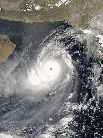
English: The Aqua satellite acquired the picture of Gonu, the most intense tropical cyclone of the Arabian Sea on record, at 12:00 Arabia Standard Time (09:00 UTC) on 4 June 2007. Although the India Meteorological Department claimed that Gonu intensified into a super cyclonic storm at 15:00 UTC, the Joint Typhoon Warning Center indicated that Gonu had started to weaken since 12:00 UTC. Based on the appearance, the picture should be at peak intensity in reality. |
| 날짜 | |
| 출처 | NASA Earth Observatory |
| 저자 | MODIS image captured by NASA’s Aqua satellite |
| 카메라 위치 | | 이 지역의 다른 사진을 보기: OpenStreetMap |
|---|
라이선스
| 이 파일은 NASA에서 제작하였으므로 퍼블릭 도메인입니다. NASA의 저작권 정책에 따르면 NASA의 자료는 명시하지 않는 이상 저작권의 보호를 받지 않습니다. (Template:PD-USGov, 또는 NASA 저작권 정책 문서, JPL 그림 사용 정책을 참고하세요.) | ||
 |
주의사항:
|
파일 역사
날짜/시간 링크를 클릭하면 해당 시간의 파일을 볼 수 있습니다.
| 날짜/시간 | 섬네일 | 크기 | 사용자 | 설명 | |
|---|---|---|---|---|---|
| 현재 | 2016년 10월 27일 (목) 19:05 | | 5,550 × 7,400 (9.84 MB) | Meow | Optimised from the original TIFF file under current standards. |
| 2007년 11월 15일 (목) 13:55 |  | 6,000 × 7,800 (7.7 MB) | Good kitty | == Summary == {{Information |Description=You might expect to see a storm with near-perfect symmetry and a well-defined eye hoovering over the warm waters of the Caribbean or in the South Pacific, but Tropical Cyclone Gonu showed up in an unusual place. On |
이 파일을 사용하는 문서
다음 문서 1개가 이 파일을 사용하고 있습니다:
이 파일을 사용하고 있는 모든 위키의 문서 목록
다음 위키에서 이 파일을 사용하고 있습니다:
- bn.wikipedia.org에서 이 파일을 사용하고 있는 문서 목록
- de.wikipedia.org에서 이 파일을 사용하고 있는 문서 목록
- en.wikipedia.org에서 이 파일을 사용하고 있는 문서 목록
- Cyclone
- North Indian Ocean tropical cyclone
- Portal:Tropical cyclones
- 2007 North Indian Ocean cyclone season
- Portal:Tropical cyclones/Anniversaries/June
- Portal:Tropical cyclones/Anniversaries/June/4
- Cyclone Gonu
- List of the most intense tropical cyclones
- Wikipedia:Today's featured article/June 3, 2010
- Wikipedia:Today's featured article/June 2010
- Tropical cyclones in 2007
- Portal:Iran/Selected article/5
- Wikipedia:Featured picture candidates/June-2013
- Wikipedia:Featured picture candidates/Super Cyclonic Storm Gonu
- List of Arabian Peninsula tropical cyclones
- Wikipedia:Today's featured list/September 2019
- Wikipedia:Today's featured list/September 6, 2019
- Wikipedia:Main Page history/2019 September 6
- es.wikipedia.org에서 이 파일을 사용하고 있는 문서 목록
- fa.wikipedia.org에서 이 파일을 사용하고 있는 문서 목록
- fr.wikipedia.org에서 이 파일을 사용하고 있는 문서 목록
- id.wikipedia.org에서 이 파일을 사용하고 있는 문서 목록
- nl.wikipedia.org에서 이 파일을 사용하고 있는 문서 목록
- pt.wikipedia.org에서 이 파일을 사용하고 있는 문서 목록
- uk.wikipedia.org에서 이 파일을 사용하고 있는 문서 목록
- vi.wikipedia.org에서 이 파일을 사용하고 있는 문서 목록
- zh.wikipedia.org에서 이 파일을 사용하고 있는 문서 목록