파일:Grossglockner from SW.jpg

미리 보기 크기: 800 × 600 픽셀 다른 해상도: 320 × 240 픽셀 | 640 × 480 픽셀 | 1,024 × 768 픽셀 | 1,280 × 960 픽셀 | 1,884 × 1,413 픽셀
원본 파일 (1,884 × 1,413 픽셀, 파일 크기: 421 KB, MIME 종류: image/jpeg)
파일 설명
| 설명 |
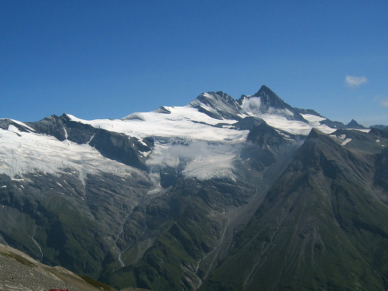
Deutsch: Großglockner vom Südwesten. Der Großglockner (3.797 m) ist der höchste pyramidenförmig erscheinende Gipfel rechts von der Mitte. Der breite großteils schneefreie Berg links davon ist die Glocknerwand (3.722 m) und ihr linker Eckpfeiler Hofmannspitze. Links im Bild ist über einer Felswand (Romariswand) der Romariswandkopf (3.511 m) zu sehen. Der pyramidenförmige Berg im Vordergrund, vor dem Großglockner, ist die Zollspitze (3.024 m).
Der Gletscher vor dem Großglockner ist das Teischnitzkees; rechts oberhalb der Romariswand ist das Fruschnitzkees. Aufnahmeort: Am Silesia Höhenweg, nahe dem Sattel nördlich des Gradötzkogel aufgenommen, in ca. 2.800 m Höhe und in 8 km Entfernung vom Gipfel des Großglockners.English: Großglockner seen from the southwest. The Großglockner (3.797 m), the highest peak of Austria, is the highest peak in the image, pyramid-shaped, right of the center. Left of it, the more elongated and mostly snow-free mountain is the Glocknerwand (3.722 m) with its left pillar Hofmannspitze. The Romariswandkopf (3.511 m) is the peak of the rock wall (Romariswand) in the left part of the image. The pyramid-shaped peak in front of the Großglockner is the Zollspitze (3.024 m). The glacier in front of the Großglockner is the Teischnitzkees, that behind and right of the Romariswand is the Fruschnitzkees. Français : Le Grossglockner vu du sud-ouest. Le Grossglockner (3797 m), est le plus haut sommet d'Autriche. La montage plus allongée et presque libre de neige à sa gauche porte le Glocknerwand (3722 m) et le Hofmannspitze. Tout à gauche, le Romariswandkopf ("Pic du mur de pierre", 3511 m) est visible. Le sommet en forme de pyramide devant le Grossglockner s'appelle Zollspitze (3024 m). Le glacier visible devant le Grossglockner est le Teischnitzkees, celui se trouvant en arrière et à droite du Romariswand, le Fruschnitzkees. |
| 날짜 | |
| 출처 | Photo taken by myself, cropped, color balance slightly adjusted. |
| 저자 | Michael Schmid |
| 다른 버전 |

라이선스
나는 아래 작품의 저작권자로서, 이 저작물을 다음과 같은 라이선스로 배포합니다:
이 파일은 크리에이티브 커먼즈 저작자표시-동일조건변경허락 2.0 오스트리아 라이선스로 배포됩니다.
- 이용자는 다음의 권리를 갖습니다:
- 공유 및 이용 – 저작물의 복제, 배포, 전시, 공연 및 공중송신
- 재창작 – 저작물의 개작, 수정, 2차적저작물 창작
- 다음과 같은 조건을 따라야 합니다:
- 저작자표시 – 적절한 저작자 표시를 제공하고, 라이센스에 대한 링크를 제공하고, 변경사항이 있는지를 표시해야 합니다. 당신은 합리적인 방식으로 표시할 수 있지만, 어떤 방식으로든 사용권 허가자가 당신 또는 당신의 사용을 지지하는 방식으로 표시할 수 없습니다.
- 동일조건변경허락 – 만약 당신이 이 저작물을 리믹스 또는 변형하거나 이 저작물을 기반으로 제작하는 경우, 당신은 당신의 기여물을 원저작물과 동일하거나 호환 가능한 라이선스에 따라 배포하여야 합니다.

|
|
파일 역사
날짜/시간 링크를 클릭하면 해당 시간의 파일을 볼 수 있습니다.
| 날짜/시간 | 섬네일 | 크기 | 사용자 | 설명 | |
|---|---|---|---|---|---|
| 현재 | 2005년 7월 11일 (월) 03:04 | | 1,884 × 1,413 (421 KB) | Schmid | {{Information |Description = Großglockner seen from the southwest | Source = Photo taken by myself, cropped, color balance slightly adjusted. | Date = 2003-Jul-30 | Author = Michael Schmid | Permission = Michael Schmid put |
이 파일을 사용하는 문서
다음 문서 1개가 이 파일을 사용하고 있습니다:
이 파일을 사용하고 있는 모든 위키의 문서 목록
다음 위키에서 이 파일을 사용하고 있습니다:
- an.wikipedia.org에서 이 파일을 사용하고 있는 문서 목록
- ar.wikipedia.org에서 이 파일을 사용하고 있는 문서 목록
- bg.wikipedia.org에서 이 파일을 사용하고 있는 문서 목록
- bn.wikipedia.org에서 이 파일을 사용하고 있는 문서 목록
- bn.wikibooks.org에서 이 파일을 사용하고 있는 문서 목록
- bs.wikipedia.org에서 이 파일을 사용하고 있는 문서 목록
- ca.wikipedia.org에서 이 파일을 사용하고 있는 문서 목록
- cs.wikipedia.org에서 이 파일을 사용하고 있는 문서 목록
- Rakousko
- Großglockner
- Karavanky
- Totes Gebirge
- Ennstalské Alpy
- Vysoké Taury
- Nízké Taury
- Hory Solné komory
- Dachstein
- Rakouské Alpy
- Zillertalské Alpy
- Ötztalské Alpy
- Stubaiské Alpy
- Gailtalské Alpy
- Steinberge
- Hochschwab
- Rax
- Berchtesgadenské Alpy
- Vídeňský les
- Gutensteinské Alpy
- Türnitzské Alpy
- Mürzstegské Alpy
- Ybbstalské Alpy
- Hornorakouské předhůří
- Tennengebirge
- Dientener Berge
- Kaisergebirge
- Chiemgauské Alpy
- Rofan
- Karwendel
- Nockberge
- Wetterstein
- Lechtalské Alpy
- Verwall
- Lechquellengebirge
- Bregenzský les (pohoří)
- Algavské Alpy
- Lavanttalské Alpy
- Villgratenské hory
- Kitzbühelské Alpy
- Tuxské Alpy
- Silvretta
이 파일의 더 많은 사용 내역을 봅니다.