파일:Haute-Normandie region location map.svg

SVG 파일의 PNG 형식의 미리보기 크기: 465 × 600 픽셀. 다른 해상도: 186 × 240 픽셀 | 372 × 480 픽셀 | 595 × 768 픽셀 | 794 × 1,024 픽셀 | 1,587 × 2,048 픽셀 | 969 × 1,250 픽셀
원본 파일 (SVG 파일, 실제 크기 969 × 1,250 픽셀, 파일 크기: 377 KB)
파일 설명
| 카메라 위치 | | 이 지역의 다른 사진을 보기: OpenStreetMap |
|---|
| 설명 |
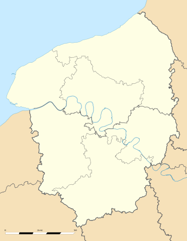
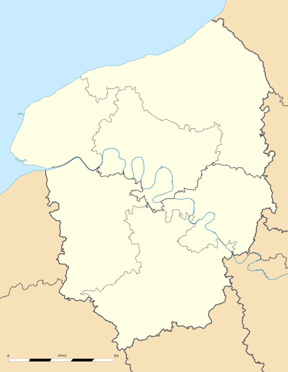
English: Blank administrative map of the region of Upper Normandy, France, for geo-location purpose, with distinct boundaries for regions, departments and arrondissements.
Français : Carte administrative vierge de la région de Haute-Normandie, France, destinée à la géolocalisation, avec limite distincte des régions, départements et arrondissements. Estimated scale: 1:560,000 (precision: 140 m)
Geographic limits of the map:
|
||
| 날짜 | |||
| 출처 |
자작
|
||
| 저자 | Eric Gaba (Sting - fr:Sting) | ||
| 저작권 (이 파일을 인용하기) |
|
||
| 다른 버전 |
|

라이선스
Eric Gaba, Wikimedia Commons user Sting은(는) 아래 작품의 저작권자로서, 해당 저작물을 다음과 같은 라이선스로 배포합니다:
이 파일은 크리에이티브 커먼즈 저작자표시-동일조건변경허락 3.0 Unported 라이선스로 배포됩니다.
저작자표시: Eric Gaba, Wikimedia Commons user Sting
- 이용자는 다음의 권리를 갖습니다:
- 공유 및 이용 – 저작물의 복제, 배포, 전시, 공연 및 공중송신
- 재창작 – 저작물의 개작, 수정, 2차적저작물 창작
- 다음과 같은 조건을 따라야 합니다:
- 저작자표시 – 적절한 저작자 표시를 제공하고, 라이센스에 대한 링크를 제공하고, 변경사항이 있는지를 표시해야 합니다. 당신은 합리적인 방식으로 표시할 수 있지만, 어떤 방식으로든 사용권 허가자가 당신 또는 당신의 사용을 지지하는 방식으로 표시할 수 없습니다.
- 동일조건변경허락 – 만약 당신이 이 저작물을 리믹스 또는 변형하거나 이 저작물을 기반으로 제작하는 경우, 당신은 당신의 기여물을 원저작물과 동일하거나 호환 가능한 라이선스에 따라 배포하여야 합니다.
파일 역사
날짜/시간 링크를 클릭하면 해당 시간의 파일을 볼 수 있습니다.
| 날짜/시간 | 섬네일 | 크기 | 사용자 | 설명 | |
|---|---|---|---|---|---|
| 현재 | 2010년 3월 11일 (목) 02:05 | | 969 × 1,250 (377 KB) | Sting | == {{int:filedesc}} == {{Location|49|21|45|N|00|56|15|E|scale:500000}} <br/> {{Information |Description={{en|Blank administrative map of the region of Upper Normandy, France, for geo-location purpose, with distinct boundaries for re |
이 파일을 사용하는 문서
다음 문서 1개가 이 파일을 사용하고 있습니다:
이 파일을 사용하고 있는 모든 위키의 문서 목록
다음 위키에서 이 파일을 사용하고 있습니다:
- ar.wikipedia.org에서 이 파일을 사용하고 있는 문서 목록
- bg.wikipedia.org에서 이 파일을 사용하고 있는 문서 목록
- ca.wikipedia.org에서 이 파일을 사용하고 있는 문서 목록
- ceb.wikipedia.org에서 이 파일을 사용하고 있는 문서 목록
- cs.wikipedia.org에서 이 파일을 사용하고 있는 문서 목록
- de.wikipedia.org에서 이 파일을 사용하고 있는 문서 목록
- el.wikipedia.org에서 이 파일을 사용하고 있는 문서 목록
- en.wikipedia.org에서 이 파일을 사용하고 있는 문서 목록
- eo.wikipedia.org에서 이 파일을 사용하고 있는 문서 목록
- es.wikipedia.org에서 이 파일을 사용하고 있는 문서 목록
- fa.wikipedia.org에서 이 파일을 사용하고 있는 문서 목록
- fr.wikipedia.org에서 이 파일을 사용하고 있는 문서 목록
- Pont de Brotonne
- École supérieure de commerce de Rouen
- Patinoire de l'Île Lacroix
- Salle des Cotonniers
- Stade Jules-Deschaseaux
- Université de Rouen-Normandie
- Aéroport Rouen Vallée de Seine
- Stade Maurice-Thoumyre
- Stade des Vertus
- Hippodrome de Rouen-Mauquenchy
- Centre commercial de Tourville-la-Rivière
- Palais des sports de Rouen
- Grand port maritime du Havre
- Stade de la Cavée verte
- Stade Marcel-Billard
- Académie de Rouen (éducation)
- Square Marcel-Halbout
- Projet:Cartographie/Cartes standards/France
- Parc de découverte Eana
- Institut national de la boulangerie pâtisserie
- Chapelle Saint-Michel d'Ingouville
- Modèle:Géolocalisation/Haute-Normandie
- Modèle:Géolocdual/Haute-Normandie
- Golf d'Étretat
- Golf du Vaudreuil
- Golf de Rouen Mont-Saint-Aignan
- Golf de Saint-Saëns
- Golf de Dieppe-Pourville
- Modèle:Géolocalisation/Haute-Normandie/Documentation
- Stade Jean-Adret
이 파일의 더 많은 사용 내역을 봅니다.