파일:La palma volcano-close.jpg

미리 보기 크기: 800 × 528 픽셀 다른 해상도: 320 × 211 픽셀 | 640 × 423 픽셀 | 1,024 × 676 픽셀 | 1,280 × 845 픽셀 | 3,022 × 1,996 픽셀
원본 파일 (3,022 × 1,996 픽셀, 파일 크기: 922 KB, MIME 종류: image/jpeg)
파일 설명
| 설명 |
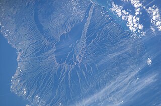
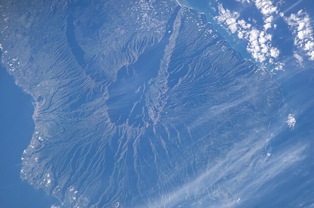
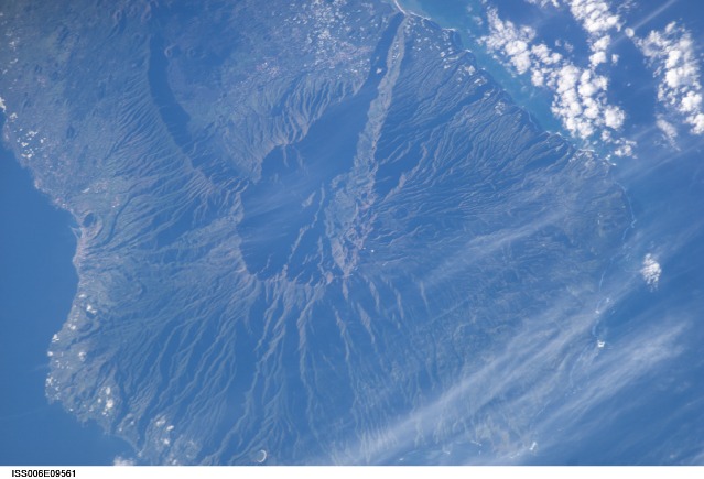
English: Satellite photo of Caldera de Taburiente and Cumbre Vieja, La Palma, Canary Islands. (South is above, North below.) Volcano, close up |
| 날짜 | |
| 출처 | JSC Gateway to Astronaut Photography of Earth |
| 저자 | Earth Science and Remote Sensing Unit, 존슨 우주 센터 |
| 다른 버전 |
http://eol.jsc.nasa.gov/DatabaseImages/ESC/small/ISS006/ISS006-E-9561.JPG |
| Mission | ISS006 |
| Roll | E |
| Frame | 9561 |
| Geographic area | the Canary Islands |
| Features | LA PALMA ISLAND, CENTRAL |
| Cloud percentage | 10% |
| Altitude | 211 nautical miles (391 km) |
| Look angle | 27° |
| Look direction | SE |
| Sun Azimuth | 133° |
| Sun Elevation | 19° |
| Camera | Kodak DCS760c Electronic Still Camera |
| Focal length | 400 mm |
| 대상 위치 | | 이 지역의 다른 사진을 보기: OpenStreetMap |
|---|
| 카메라 위치 | | 이 지역의 다른 사진을 보기: OpenStreetMap |
|---|
This image or video was catalogued by Johnson Space Center of the United States National Aeronautics and Space Administration (NASA) under Photo ID: ISS006-E-09561. This tag does not indicate the copyright status of the attached work. A normal copyright tag is still required. See Commons:Licensing. Other languages:
|
라이선스
| 이 파일은 NASA에서 제작하였으므로 퍼블릭 도메인입니다. NASA의 저작권 정책에 따르면 NASA의 자료는 명시하지 않는 이상 저작권의 보호를 받지 않습니다. (Template:PD-USGov, 또는 NASA 저작권 정책 문서, JPL 그림 사용 정책을 참고하세요.) | ||
 |
주의사항:
|
파일 역사
날짜/시간 링크를 클릭하면 해당 시간의 파일을 볼 수 있습니다.
| 날짜/시간 | 섬네일 | 크기 | 사용자 | 설명 | |
|---|---|---|---|---|---|
| 현재 | 2020년 3월 7일 (토) 23:45 | | 3,022 × 1,996 (922 KB) | Lojwe | Cropped < 1 % horizontally, 3 % vertically using CropTool with precise mode. |
| 2015년 10월 13일 (화) 11:26 |  | 3,032 × 2,064 (943 KB) | Xb2u7Zjzc32 | ISS006-E-09561 3032 x 2064 pixels | |
| 2008년 3월 17일 (월) 18:39 |  | 639 × 422 (61 KB) | Mbdortmund | ||
| 2004년 12월 30일 (목) 14:15 |  | 639 × 435 (70 KB) | Clngre~commonswiki | Satellite photo of Cumbre Vieja, La Palma, Canary Islands. Volcano, close up {{PD-USGov-NASA}} |
이 파일을 사용하는 문서
다음 문서 1개가 이 파일을 사용하고 있습니다:
이 파일을 사용하고 있는 모든 위키의 문서 목록
다음 위키에서 이 파일을 사용하고 있습니다:
- ca.wikipedia.org에서 이 파일을 사용하고 있는 문서 목록
- cs.wikipedia.org에서 이 파일을 사용하고 있는 문서 목록
- da.wikipedia.org에서 이 파일을 사용하고 있는 문서 목록
- de.wikipedia.org에서 이 파일을 사용하고 있는 문서 목록
- en.wikipedia.org에서 이 파일을 사용하고 있는 문서 목록
- es.wikipedia.org에서 이 파일을 사용하고 있는 문서 목록
- fr.wikipedia.org에서 이 파일을 사용하고 있는 문서 목록
- it.wikipedia.org에서 이 파일을 사용하고 있는 문서 목록
- nn.wikipedia.org에서 이 파일을 사용하고 있는 문서 목록
- no.wikipedia.org에서 이 파일을 사용하고 있는 문서 목록
- oc.wikipedia.org에서 이 파일을 사용하고 있는 문서 목록
- pt.wikipedia.org에서 이 파일을 사용하고 있는 문서 목록
- ru.wikipedia.org에서 이 파일을 사용하고 있는 문서 목록
- simple.wikipedia.org에서 이 파일을 사용하고 있는 문서 목록
- sk.wikipedia.org에서 이 파일을 사용하고 있는 문서 목록
- sl.wikipedia.org에서 이 파일을 사용하고 있는 문서 목록
- sv.wikipedia.org에서 이 파일을 사용하고 있는 문서 목록
- uk.wikipedia.org에서 이 파일을 사용하고 있는 문서 목록
- www.wikidata.org에서 이 파일을 사용하고 있는 문서 목록