파일:Lake rotorua.jpg

미리 보기 크기: 800 × 593 픽셀 다른 해상도: 320 × 237 픽셀 | 640 × 474 픽셀 | 1,024 × 758 픽셀 | 1,280 × 948 픽셀
원본 파일 (1,280 × 948 픽셀, 파일 크기: 223 KB, MIME 종류: image/jpeg)
파일 설명
| 설명 |
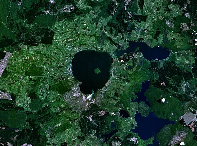
English: en:NASA World Wind false-colour landsat-7 composite satellite photo of en:Lake Rotorua in en:New Zealand. en:Category:Taupo Volcanic Zone |
| 출처 | en:NASA World Wind |
| 저자 | en:NASA World Wind |
라이선스
| This image is in the public domain because it is a screenshot from NASA’s globe software World Wind using a public domain layer, such as Blue Marble, MODIS, Landsat, SRTM, USGS or GLOBE.
|
 |
기존 올리기 기록
The original description page was here. All following user names refer to en.wikipedia.
- 2005-03-27 02:00 John Fader 1280×948×8 (227865 bytes) [[NASA World Wind]] false-colour landsat-7 composite satellite photo of [[Lake Rotorua]] in [[New Zealand]]. {{PD-USGov-NASA}}
파일 역사
날짜/시간 링크를 클릭하면 해당 시간의 파일을 볼 수 있습니다.
| 날짜/시간 | 섬네일 | 크기 | 사용자 | 설명 | |
|---|---|---|---|---|---|
| 현재 | 2008년 1월 4일 (금) 01:16 | | 1,280 × 948 (223 KB) | Rémih | {{Information |Description={{en|en:NASA World Wind false-colour landsat-7 composite satellite photo of en:Lake Rotorua in en:New Zealand. en:Category:Taupo Volcanic Zone}} |Source=Transfered from [http://en.wikipedia.org en.wikipedia] |
이 파일을 사용하는 문서
이 파일을 사용하고 있는 모든 위키의 문서 목록
다음 위키에서 이 파일을 사용하고 있습니다:
- an.wikipedia.org에서 이 파일을 사용하고 있는 문서 목록
- ar.wikipedia.org에서 이 파일을 사용하고 있는 문서 목록
- arz.wikipedia.org에서 이 파일을 사용하고 있는 문서 목록
- ceb.wikipedia.org에서 이 파일을 사용하고 있는 문서 목록
- de.wikipedia.org에서 이 파일을 사용하고 있는 문서 목록
- el.wikipedia.org에서 이 파일을 사용하고 있는 문서 목록
- en.wikipedia.org에서 이 파일을 사용하고 있는 문서 목록
- eo.wikipedia.org에서 이 파일을 사용하고 있는 문서 목록
- fr.wikipedia.org에서 이 파일을 사용하고 있는 문서 목록
- it.wikipedia.org에서 이 파일을 사용하고 있는 문서 목록
- ja.wikipedia.org에서 이 파일을 사용하고 있는 문서 목록
- no.wikipedia.org에서 이 파일을 사용하고 있는 문서 목록
- pl.wikipedia.org에서 이 파일을 사용하고 있는 문서 목록
- ru.wikipedia.org에서 이 파일을 사용하고 있는 문서 목록
- sk.wikipedia.org에서 이 파일을 사용하고 있는 문서 목록
- sl.wikipedia.org에서 이 파일을 사용하고 있는 문서 목록
- www.wikidata.org에서 이 파일을 사용하고 있는 문서 목록
- zh.wikipedia.org에서 이 파일을 사용하고 있는 문서 목록