파일:Lizars Mexico & Guatimala 1836 UTA (detail of Texas).jpg
미리 보기 크기: 694 × 600 픽셀 다른 해상도: 278 × 240 픽셀 | 555 × 480 픽셀 | 889 × 768 픽셀 | 1,185 × 1,024 픽셀 | 1,357 × 1,173 픽셀
원본 파일 (1,357 × 1,173 픽셀, 파일 크기: 983 KB, MIME 종류: image/jpeg)
파일 설명
| 제목 |
English: Mexico & Guatimala [sic] |
||||||||||||||||||||||||||
| 묘사 |
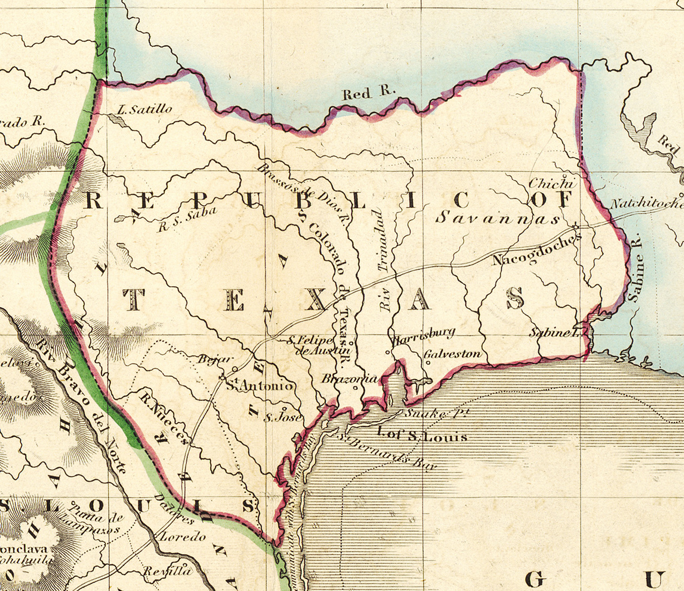
English: Shortly after Texas declared its independence from Mexico in 1836, the Edinburgh painter, engraver, printer, cartographer, lithographer, and publisher William Home Lizars (1788-1859), brother of Daniel Lizars II (1793-1875), updated the original plate for the map of Mexico & Guatemala to include the new republic. He added the towns of Galveston, Harrisburg, Brazoria, S. Felipe de Austin (although recently destroyed), Bejar, and "S. Jose" (probably intended to represent Goliad). Lizars made no further improvements to the general cartographic shape of the republic except to show the Nueces River as the southern boundary and the western boundary curving to the point where the 100th meridian strikes the Red River. The map continues to show Mexico's administrative districts as Spanish Intendencies (Intendencias) and Internal Provinces (Provincias Internas) over fifteen years since Mexico's independence. |
||||||||||||||||||||||||||
| 날짜 | 1836년경 | ||||||||||||||||||||||||||
| 출처 | UTA Libraries Cartographic Connections: 지도 / text | ||||||||||||||||||||||||||
| 창작자 |
|
||||||||||||||||||||||||||
| 크레디트 라인 |
English: The University of Texas at Arlington Libraries Special Collections, Gift of Lewis & Virginia Buttery |
||||||||||||||||||||||||||
| 지리 정보 | |||||||||||||||||||||||||||
| 지도 위치 | 텍사스주 | ||||||||||||||||||||||||||
| 지리 참고 | 부적절한 경우에 숨기려면 warp_status = skip로 설정하세요. | ||||||||||||||||||||||||||
| 서적 정보 | |||||||||||||||||||||||||||
| 출판 장소 | 에든버러 | ||||||||||||||||||||||||||
| 출판사 |
|
||||||||||||||||||||||||||
| 보관 기록 자료 | |||||||||||||||||||||||||||
| Collection |
|
||||||||||||||||||||||||||
| 크기 | 높이: 42 cm; 너비: 51.5 cm | ||||||||||||||||||||||||||
| 기법 | colored engraving on paper | ||||||||||||||||||||||||||
| artwork-references |
Worms, Laurence; Ashley Baynton-Williams (2011년) British Map Engravers, 런던: Rare Book Society, pp. 406–409 |
||||||||||||||||||||||||||
| 다른 버전 | |||||||||||||||||||||||||||

.jpg?uselang=ko)
라이선스

|
This file was provided to Wikimedia Commons by the University of Texas at Arlington Libraries as part of a cooperation project. The University of Texas at Arlington Libraries is part of the University of Texas at Arlington, a public research university located in Arlington, Texas.
|
|
저작자가 1859년에 사망한 이 작품은 미국, 그리고 저작권 보호 기간이 저작자 사후 100년, 또는 그 이하인 모든 국가에서 퍼블릭 도메인입니다. 이 작품은 1929년 1월 1일 이전에 출판하였으므로 미국에서 퍼블릭 도메인입니다. | |
| 이 저작물은 모든 저작인접권을 포함한 저작권법하의 규제로부터 자유로운 것으로 확인되었습니다. | |
파일 역사
날짜/시간 링크를 클릭하면 해당 시간의 파일을 볼 수 있습니다.
| 날짜/시간 | 섬네일 | 크기 | 사용자 | 설명 | |
|---|---|---|---|---|---|
| 현재 | 2019년 7월 14일 (일) 00:18 | | 1,357 × 1,173 (983 KB) | Michael Barera | File:Lizars Mexico & Guatimala 1836 UTA.jpg cropped 79 % horizontally, 78 % vertically using CropTool with precise mode. |
이 파일을 사용하는 문서
다음 문서 1개가 이 파일을 사용하고 있습니다:
이 파일을 사용하고 있는 모든 위키의 문서 목록
다음 위키에서 이 파일을 사용하고 있습니다:
- azb.wikipedia.org에서 이 파일을 사용하고 있는 문서 목록
- ca.wikipedia.org에서 이 파일을 사용하고 있는 문서 목록
- cv.wikipedia.org에서 이 파일을 사용하고 있는 문서 목록
- en.wikipedia.org에서 이 파일을 사용하고 있는 문서 목록
- eo.wikipedia.org에서 이 파일을 사용하고 있는 문서 목록
- fa.wikipedia.org에서 이 파일을 사용하고 있는 문서 목록
- it.wikipedia.org에서 이 파일을 사용하고 있는 문서 목록
- ja.wikipedia.org에서 이 파일을 사용하고 있는 문서 목록
- mk.wikipedia.org에서 이 파일을 사용하고 있는 문서 목록
- mzn.wikipedia.org에서 이 파일을 사용하고 있는 문서 목록
- pl.wikipedia.org에서 이 파일을 사용하고 있는 문서 목록
- pt.wikipedia.org에서 이 파일을 사용하고 있는 문서 목록
- sv.wikipedia.org에서 이 파일을 사용하고 있는 문서 목록
- th.wikipedia.org에서 이 파일을 사용하고 있는 문서 목록
- yi.wikipedia.org에서 이 파일을 사용하고 있는 문서 목록
- zh-min-nan.wikipedia.org에서 이 파일을 사용하고 있는 문서 목록
.jpg)