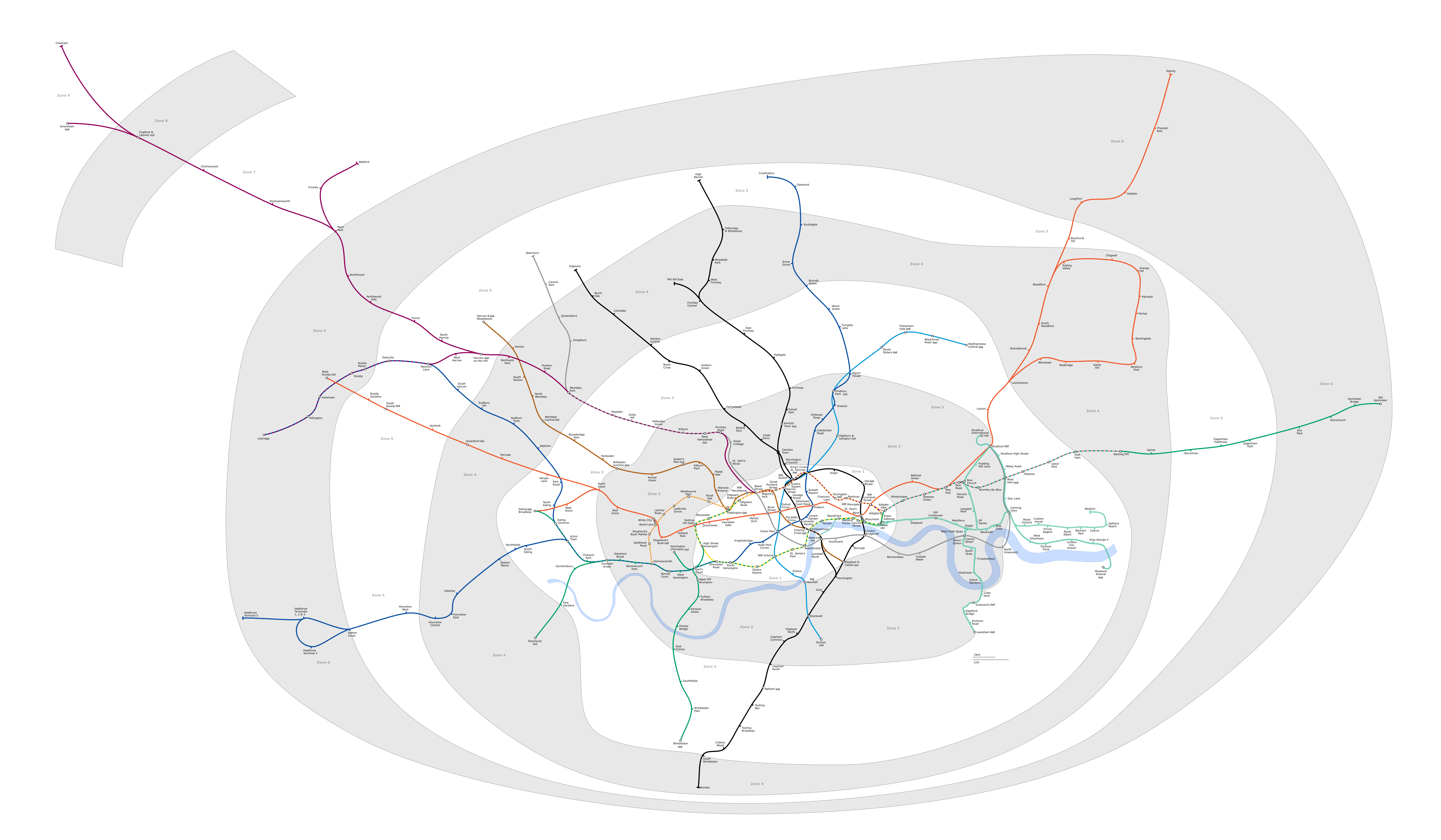
파일:London Underground full map.png
미리 보기 크기: 800 × 467 픽셀 다른 해상도: 320 × 187 픽셀 | 640 × 373 픽셀 | 1,024 × 597 픽셀 | 1,280 × 747 픽셀 | 2,560 × 1,493 픽셀 | 6,000 × 3,500 픽셀
원본 파일 (6,000 × 3,500 픽셀, 파일 크기: 1.36 MB, MIME 종류: image/png)
Generated as part of the London Underground geographic maps project by software written by ed g2s • talk and James D. Forrester utilising GPS data.
NB: Routes between stations are interpolated and may not be geographically accurate

|
GNU 자유 문서 사용 허가서 1.2판 또는 자유 소프트웨어 재단에서 발행한 이후 판의 규정에 따라 본 문서를 복제하거나 개작 및 배포할 수 있습니다. 본 문서에는 변경 불가 부분이 없으며, 앞 표지 구절과 뒷 표지 구절도 없습니다. 본 사용 허가서의 전체 내용은 GNU 자유 문서 사용 허가서 부분에 포함되어 있습니다. |
| 이 파일은 크리에이티브 커먼즈 저작자표시-동일조건변경허락 3.0 Unported 라이선스로 배포됩니다. | ||
| ||
| 이 라이선스 틀은 GFDL 라이선스 변경의 일부로 이 파일에 추가되었습니다. |
- 이용자는 다음의 권리를 갖습니다:
- 공유 및 이용 – 저작물의 복제, 배포, 전시, 공연 및 공중송신
- 재창작 – 저작물의 개작, 수정, 2차적저작물 창작
- 다음과 같은 조건을 따라야 합니다:
- 저작자표시 – 적절한 저작자 표시를 제공하고, 라이센스에 대한 링크를 제공하고, 변경사항이 있는지를 표시해야 합니다. 당신은 합리적인 방식으로 표시할 수 있지만, 어떤 방식으로든 사용권 허가자가 당신 또는 당신의 사용을 지지하는 방식으로 표시할 수 없습니다.
- 동일조건변경허락 – 만약 당신이 이 저작물을 리믹스 또는 변형하거나 이 저작물을 기반으로 제작하는 경우, 당신은 당신의 기여물을 원저작물과 동일하거나 호환 가능한 라이선스에 따라 배포하여야 합니다.
Upload log
Latest versions of this file are uploaded from wts.wikivoyage-old.org.
The original description page was here. All following user names refer to wts.wikivoyage-old.
org:
- 2010-02-11 19:08:44 4100×2374 (1,076,793 bytes) (WT-shared) Peterfitzgerald attempted fix (Import from wikitravel.org/shared)
- 2009-12-20 21:41:21 4000×2312 (827,759 bytes) (WT-shared) Peterfitzgerald increase resolution (Import from wikitravel.org/shared)
- 2009-12-20 00:59:42 3000×1734 (571,486 bytes) (WT-shared) Peterfitzgerald == Summary == {{Imagecredit|credit=[[:wmc:User:DavidCane]], [[:wmc:User:Ed g2s]], Peter Fitzgerald|captureDate=19 December 2009|location=Lon (Import from wikitravel.org/shared)
파일 역사
날짜/시간 링크를 클릭하면 해당 시간의 파일을 볼 수 있습니다.
| 날짜/시간 | 섬네일 | 크기 | 사용자 | 설명 | |
|---|---|---|---|---|---|
| 현재 | 2018년 2월 5일 (월) 08:23 | | 6,000 × 3,500 (1.36 MB) | DavidCane | Amend to correspond to svg version |
| 2015년 10월 8일 (목) 22:04 |  | 6,000 × 3,500 (1.1 MB) | RokerHRO | optipng -o7 -i0 -zc1-9 -zm1-9 -zs0-3 -f0-5 → 19.47% decrease | |
| 2014년 8월 12일 (화) 12:26 |  | 6,000 × 3,500 (1.36 MB) | Jc86035 | Updated again | |
| 2014년 8월 8일 (금) 21:07 |  | 6,000 × 3,500 (1.35 MB) | Jc86035 | again, updated from SVG version | |
| 2013년 12월 4일 (수) 00:15 |  | 6,000 × 3,500 (1.35 MB) | Jc86035 | Updated from SVG at File:London Underground full map.svg | |
| 2012년 11월 22일 (목) 17:42 |  | 4,000 × 2,320 (274 KB) | Atsirlin | Reverted to version as of 01:42, 6 January 2007: OK, importing new versions was a bad idea... | |
| 2012년 11월 22일 (목) 17:32 |  | 4,100 × 2,374 (1.03 MB) | OgreBot | (BOT): Uploading old version of file from wts.wikivoyage-old; originally uploaded on 2010-02-11 19:08:44 by (WT-shared) Peterfitzgerald | |
| 2012년 11월 22일 (목) 17:32 |  | 4,000 × 2,312 (808 KB) | OgreBot | (BOT): Uploading old version of file from wts.wikivoyage-old; originally uploaded on 2009-12-20 21:41:21 by (WT-shared) Peterfitzgerald | |
| 2012년 11월 22일 (목) 17:32 |  | 3,000 × 1,734 (558 KB) | OgreBot | (BOT): Uploading old version of file from wts.wikivoyage-old; originally uploaded on 2009-12-20 00:59:42 by (WT-shared) Peterfitzgerald | |
| 2007년 1월 6일 (토) 10:42 |  | 4,000 × 2,320 (274 KB) | Ed g2s | new zone 4 boundary |
이 파일을 사용하는 문서
다음 문서 2개가 이 파일을 사용하고 있습니다:
이 파일을 사용하고 있는 모든 위키의 문서 목록
다음 위키에서 이 파일을 사용하고 있습니다:
- da.wikipedia.org에서 이 파일을 사용하고 있는 문서 목록
- en.wikipedia.org에서 이 파일을 사용하고 있는 문서 목록
- en.wikivoyage.org에서 이 파일을 사용하고 있는 문서 목록
- es.wikipedia.org에서 이 파일을 사용하고 있는 문서 목록
- fr.wikivoyage.org에서 이 파일을 사용하고 있는 문서 목록
- he.wikipedia.org에서 이 파일을 사용하고 있는 문서 목록
- hi.wikipedia.org에서 이 파일을 사용하고 있는 문서 목록
- hu.wikipedia.org에서 이 파일을 사용하고 있는 문서 목록
- ja.wikipedia.org에서 이 파일을 사용하고 있는 문서 목록
- nap.wikipedia.org에서 이 파일을 사용하고 있는 문서 목록
- nl.wikipedia.org에서 이 파일을 사용하고 있는 문서 목록
- Acton Town (metrostation)
- Alperton (metrostation)
- Amersham (metrostation)
- Arnos Grove (metrostation)
- Dagenham East (metrostation)
- Debden (metrostation)
- Dagenham Heathway (metrostation)
- Fairlop (metrostation)
- Finchley Central (metrostation)
- Ickenham (metrostation)
- Station Balham
- Barkingside (metrostation)
- Becontree (metrostation)
- Boston Manor (metrostation)
- Bounds Green (metrostation)
- Brent Cross (metrostation)
- Buckhurst Hill (metrostation)
- Burnt Oak (metrostation)
- Oakwood (metrostation)
- Osterley (metrostation)
- Stanmore (metrostation)
- Gants Hill (metrostation)
- Grange Hill (metrostation)
- Canons Park (metrostation)
- Station Chalfont & Latimer
- Chesham (metrostation)
- Chigwell (metrostation)
- Station Chorleywood
- Cockfosters (metrostation)
- Colindale (metrostation)
- Colliers Wood (metrostation)
- Croxley (metrostation)
- Custom House for ExCeL
- Cyprus (metrostation)
- Queensbury (metrostation)
- Station Upminster
이 파일의 더 많은 사용 내역을 봅니다.