파일:MK-07403 China Wall (Halls Creek).jpg

원본 파일(2,469 × 1,646 픽셀, 파일 크기: 3.98 MB, MIME 종류: image/jpeg)

파일 설명

설명
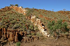
Deutsch: Die sog. ChinaWall nahe Halls Creek, Western Australia, Australia
English: The so called »ChinaWall« near Halls Creek, Western Australia, Australia
날짜
출처 자작
저자 Martin Kraft
저작권
(이 파일을 인용하기)

Reusing this image

Image: Martin Kraft (photo.martinkraft.com)
License: CC BY-SA 3.0
via Wikimedia Commons

This image was published by Martin Kraft under the free license CC BY-SA 3.0, which also allows the usage outside of Wikipedia under the following conditions:

  • If you remix, transform, or build upon the material, you must distribute your contributions under the same license as the original.

Please send me a specimen copy or the URL of the website where the image is used.


The Online Attribution Generator offers a good tool to generate an attribution sufficient for your use case.


Feel free to contact me via eMail photo@martinkraft.com or visit my website photo.martinkraft.com for any questions or in case you need...

  • a licenses to use the image without the requirements of the above terms and conditions
  • a higher resolution or a different crop of the same subject
  • or similar graphics and photographs

Only the terms and conditions mentioned above authorize the free use of this image. Any infringement causes a copyright violation, that may result in a penalty fee of five times the fee suggested by the MFM, inter alia.

카메라 위치18° 14′ 59.4″ S, 127° 43′ 23.46″ E Kartographer map based on OpenStreetMap.이 지역의 다른 사진을 보기: OpenStreetMapinfo

라이선스

Martin Kraft // photo.martinkraft.com은(는) 아래 작품의 저작권자로서, 해당 저작물을 다음과 같은 라이선스로 배포합니다:
w:ko:크리에이티브 커먼즈
저작자표시 동일조건변경허락
이용자는 다음의 권리를 갖습니다:
  • 공유 및 이용 – 저작물의 복제, 배포, 전시, 공연 및 공중송신
  • 재창작 – 저작물의 개작, 수정, 2차적저작물 창작
다음과 같은 조건을 따라야 합니다:
  • 저작자표시 – 적절한 저작자 표시를 제공하고, 라이센스에 대한 링크를 제공하고, 변경사항이 있는지를 표시해야 합니다. 당신은 합리적인 방식으로 표시할 수 있지만, 어떤 방식으로든 사용권 허가자가 당신 또는 당신의 사용을 지지하는 방식으로 표시할 수 없습니다.
  • 동일조건변경허락 – 만약 당신이 이 저작물을 리믹스 또는 변형하거나 이 저작물을 기반으로 제작하는 경우, 당신은 당신의 기여물을 원저작물과 동일하거나 호환 가능한 라이선스에 따라 배포하여야 합니다.

설명

이 파일이 나타내는 바에 대한 한 줄 설명을 추가합니다

18°14'59.399"S, 127°43'23.459"E

파일 역사

날짜/시간 링크를 클릭하면 해당 시간의 파일을 볼 수 있습니다.

날짜/시간섬네일크기사용자설명
현재2016년 5월 25일 (수) 03:032016년 5월 25일 (수) 03:03 판의 섬네일2,469 × 1,646 (3.98 MB)Martin KraftBetter Resolution (LrMediaWiki 0.4.1)
2011년 9월 30일 (금) 19:562011년 9월 30일 (금) 19:56 판의 섬네일1,440 × 960 (1.03 MB)Martin Kraft

이 파일을 사용하는 문서가 없습니다.

이 파일을 사용하고 있는 모든 위키의 문서 목록

다음 위키에서 이 파일을 사용하고 있습니다:

  • de.wikipedia.org에서 이 파일을 사용하고 있는 문서 목록
  • en.wikipedia.org에서 이 파일을 사용하고 있는 문서 목록
  • hu.wikipedia.org에서 이 파일을 사용하고 있는 문서 목록
  • lt.wikipedia.org에서 이 파일을 사용하고 있는 문서 목록
  • meta.wikimedia.org에서 이 파일을 사용하고 있는 문서 목록
  • pl.wikipedia.org에서 이 파일을 사용하고 있는 문서 목록
  • pl.wikivoyage.org에서 이 파일을 사용하고 있는 문서 목록
  • www.wikidata.org에서 이 파일을 사용하고 있는 문서 목록
메타데이터