파일:Map South Korea de.png
미리 보기 크기: 522 × 600 픽셀 다른 해상도: 209 × 240 픽셀 | 591 × 679 픽셀
원본 파일 (591 × 679 픽셀, 파일 크기: 59 KB, MIME 종류: image/png)
파일 설명
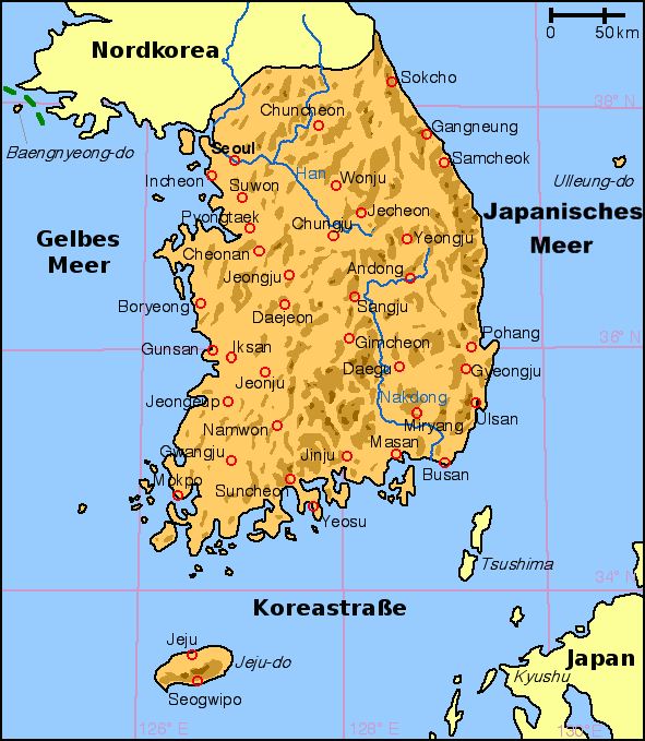
English: Map of South Korea with German labels
Deutsch: Karte von Südkorea mit deutscher Beschriftung
English: Other versions: Image:Map South Korea blank.png
English: From en:Image:Korea south map.png, created by en:User:Kokiri (small modifications by myself).
라이선스
| 이 파일은 크리에이티브 커먼즈 저작자표시-동일조건변경허락 3.0 Unported 라이선스로 배포됩니다. 면책 조항이 적용됩니다. | ||
| ||
| 이 라이선스 틀은 GFDL 라이선스 변경의 일부로 이 파일에 추가되었습니다. |

|
GNU 자유 문서 사용 허가서 1.2판 또는 자유 소프트웨어 재단에서 발행한 이후 판의 규정에 따라 본 문서를 복제하거나 개작 및 배포할 수 있습니다. 본 문서에는 변경 불가 부분이 없으며, 앞 표지 구절과 뒷 표지 구절도 없습니다. 본 사용 허가서의 전체 내용은 GNU 자유 문서 사용 허가서 부분에 포함되어 있습니다. 면책 조항이 적용됩니다. |
파일 역사
날짜/시간 링크를 클릭하면 해당 시간의 파일을 볼 수 있습니다.
| 날짜/시간 | 섬네일 | 크기 | 사용자 | 설명 | |
|---|---|---|---|---|---|
| 현재 | 2009년 1월 27일 (화) 05:25 | | 591 × 679 (59 KB) | Valentim | Namensdarstellung des Japanischen Meeres aufgrund w:de:Wikipedia:Namensgebung#Anderssprachige_Gebiete geändert. |
| 2008년 11월 11일 (화) 02:00 |  | 591 × 679 (57 KB) | Slomox | ||
| 2005년 11월 28일 (월) 22:27 |  | 591 × 679 (29 KB) | IGEL | {{en|Map of South Korea with German labels}} {{de|Karte von Südkorea mit deutscher Beschriftung}} {{en|Other versions: Image:Map South Korea blank.png}} {{en|From en:Image:Korea south map.png, created by en:User:Kokiri (small modification |
이 파일을 사용하는 문서
이 파일을 사용하는 문서가 없습니다.
이 파일을 사용하고 있는 모든 위키의 문서 목록
다음 위키에서 이 파일을 사용하고 있습니다:
- de.wikipedia.org에서 이 파일을 사용하고 있는 문서 목록
- de.wikinews.org에서 이 파일을 사용하고 있는 문서 목록
- de.wiktionary.org에서 이 파일을 사용하고 있는 문서 목록