파일:Map of Sealand with territorial waters.png

원본 파일 (1,174 × 1,200 픽셀, 파일 크기: 55 KB, MIME 종류: image/png)
| 묘사 |
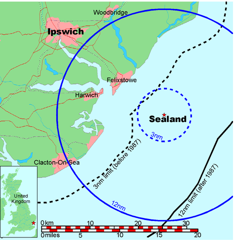
Map of Sealand This is a map of the coast of England near Ipswich, showing the location of Sealand. The boundaries of the territorial water of the United Kingdom are also drawn, both the 3 nautical mile limit (5.556km) before 1987 and the 12nm limit (22.22km) after 1987. The same radii are also given around Sealand. Note that these boundaries are derived based on the circular distance from the coastline, and not copied from official maps. This map is not suitable for navigation or for determining the boundaries of the UK territorial waters for legal or other purposes.
|
|||||||||
| 창작자 |
Map generated by DEMIS World Map Server and edited by Chris 73 |
|||||||||
| 저작권 (이 파일을 인용하기) |
|
|||||||||
| 지리 정보 | ||||||||||
| 영역 상자 |
|
|||||||||
| 지리 참고 | ||||||||||

파일 역사
날짜/시간 링크를 클릭하면 해당 시간의 파일을 볼 수 있습니다.
| 날짜/시간 | 섬네일 | 크기 | 사용자 | 설명 | |
|---|---|---|---|---|---|
| 현재 | 2006년 7월 10일 (월) 04:41 | | 1,174 × 1,200 (55 KB) | Chris 73 | update |
| 2005년 1월 26일 (수) 19:00 |  | 1,024 × 1,046 (50 KB) | Chris 73 |
이 파일을 사용하는 문서
다음 문서 2개가 이 파일을 사용하고 있습니다:
이 파일을 사용하고 있는 모든 위키의 문서 목록
다음 위키에서 이 파일을 사용하고 있습니다:
- af.wikipedia.org에서 이 파일을 사용하고 있는 문서 목록
- be-tarask.wikipedia.org에서 이 파일을 사용하고 있는 문서 목록
- be.wikipedia.org에서 이 파일을 사용하고 있는 문서 목록
- de.wikipedia.org에서 이 파일을 사용하고 있는 문서 목록
- en.wikipedia.org에서 이 파일을 사용하고 있는 문서 목록
- eo.wikipedia.org에서 이 파일을 사용하고 있는 문서 목록
- fy.wikipedia.org에서 이 파일을 사용하고 있는 문서 목록
- hi.wikipedia.org에서 이 파일을 사용하고 있는 문서 목록
- hr.wikipedia.org에서 이 파일을 사용하고 있는 문서 목록
- hu.wikipedia.org에서 이 파일을 사용하고 있는 문서 목록
- lb.wikipedia.org에서 이 파일을 사용하고 있는 문서 목록
- os.wikipedia.org에서 이 파일을 사용하고 있는 문서 목록
- pl.wikipedia.org에서 이 파일을 사용하고 있는 문서 목록
- wa.wikipedia.org에서 이 파일을 사용하고 있는 문서 목록