파일:Map provinces Netherlands-en.svg

SVG 파일의 PNG 형식의 미리보기 크기: 506 × 600 픽셀. 다른 해상도: 202 × 240 픽셀 | 405 × 480 픽셀 | 648 × 768 픽셀 | 864 × 1,024 픽셀 | 1,727 × 2,048 픽셀 | 743 × 881 픽셀
원본 파일 (SVG 파일, 실제 크기 743 × 881 픽셀, 파일 크기: 1,003 KB)

|
이 SVG 파일은 편집 가능한 문자를 사용하므로 Inkscape나 Adobe Illustrator를 사용하여 쉽게 다른 언어로 번역할 수 있습니다. 여기를 참고하세요. 또한 텍스트 편집기를 이용하여 수동으로 파일을 번역할 수도 있습니다. |
파일 설명
| 설명 |
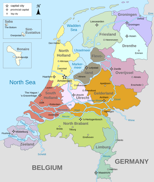
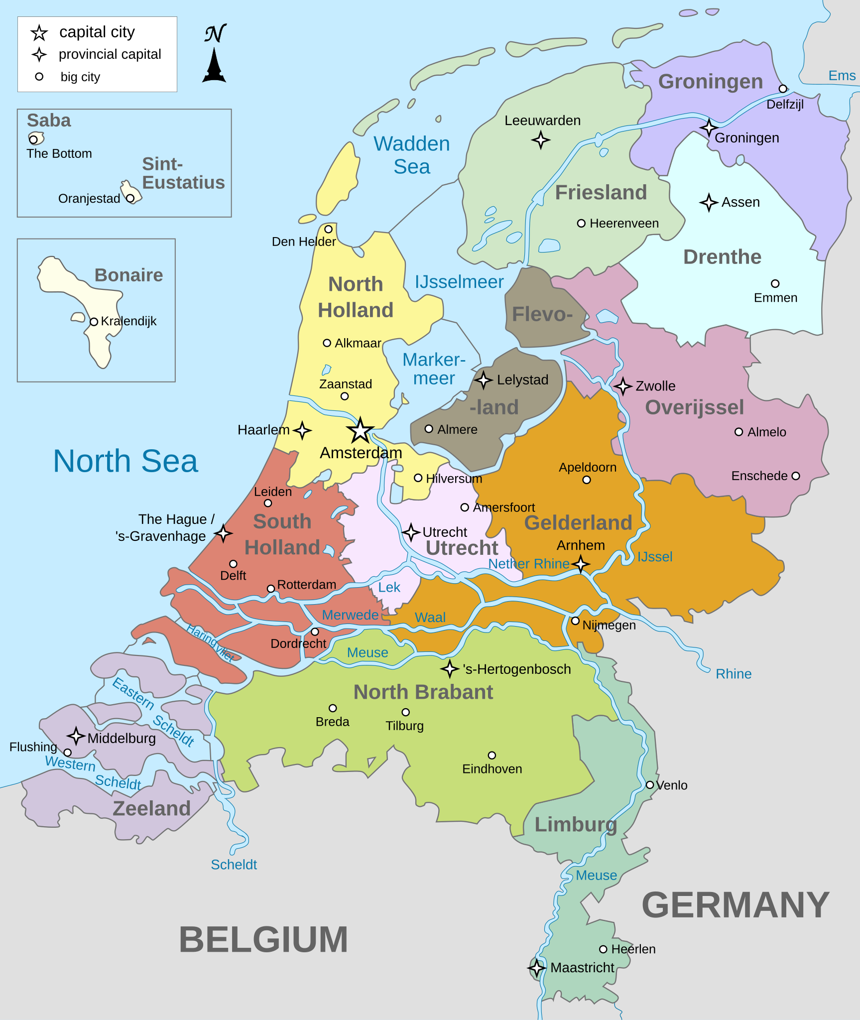
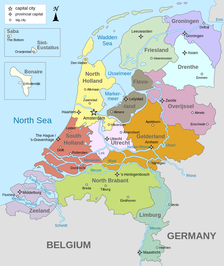
English: Map of The Netherlands (including the special municipalities of Saba, Saint Eustatius and Bonaire; the Caribbean Netherlands), showing provinces, large cities, rivers and lakes. English version
Deutsch: Karte der Niederlande, mit den Provinzen, der Karibischen Niederlande, den Großstädten und den Flüssen und Seen. Englische Version
Bahasa Indonesia: Peta Belanda (termasuk munisipal khusus Saba, Saint Eustatius dan Bonaire; Belanda Karibia), menampilkan provinsi, kota besar, sungai dan danau. Versi bahasa Inggris |
| 날짜 | |
| 출처 | 자작 |
| 저자 | Alphathon |
| 다른 버전 |
[]
|


.svg)
라이선스
나는 아래 작품의 저작권자로서, 이 저작물을 다음과 같은 라이선스로 배포합니다:
이 파일은 크리에이티브 커먼즈 저작자표시-동일조건변경허락 3.0 Unported 라이선스로 배포됩니다.
- 이용자는 다음의 권리를 갖습니다:
- 공유 및 이용 – 저작물의 복제, 배포, 전시, 공연 및 공중송신
- 재창작 – 저작물의 개작, 수정, 2차적저작물 창작
- 다음과 같은 조건을 따라야 합니다:
- 저작자표시 – 적절한 저작자 표시를 제공하고, 라이센스에 대한 링크를 제공하고, 변경사항이 있는지를 표시해야 합니다. 당신은 합리적인 방식으로 표시할 수 있지만, 어떤 방식으로든 사용권 허가자가 당신 또는 당신의 사용을 지지하는 방식으로 표시할 수 없습니다.
- 동일조건변경허락 – 만약 당신이 이 저작물을 리믹스 또는 변형하거나 이 저작물을 기반으로 제작하는 경우, 당신은 당신의 기여물을 원저작물과 동일하거나 호환 가능한 라이선스에 따라 배포하여야 합니다.

|
GNU 자유 문서 사용 허가서 1.2판 또는 자유 소프트웨어 재단에서 발행한 이후 판의 규정에 따라 본 문서를 복제하거나 개작 및 배포할 수 있습니다. 본 문서에는 변경 불가 부분이 없으며, 앞 표지 구절과 뒷 표지 구절도 없습니다. 본 사용 허가서의 전체 내용은 GNU 자유 문서 사용 허가서 부분에 포함되어 있습니다. |
이 라이선스 중에서 목적에 맞는 것을 선택하여 사용할 수 있습니다.
파일 역사
날짜/시간 링크를 클릭하면 해당 시간의 파일을 볼 수 있습니다.
| 날짜/시간 | 섬네일 | 크기 | 사용자 | 설명 | |
|---|---|---|---|---|---|
| 현재 | 2024년 1월 20일 (토) 04:28 | | 743 × 881 (1,003 KB) | Illchy | File uploaded using svgtranslate tool (https://svgtranslate.toolforge.org/). Added translation for id. |
| 2023년 4월 30일 (일) 02:43 |  | 743 × 881 (987 KB) | Dymitr | File uploaded using svgtranslate tool (https://svgtranslate.toolforge.org/). Added translation for be-tarask. | |
| 2021년 11월 25일 (목) 18:27 |  | 743 × 881 (909 KB) | Andrei Stroe | File uploaded using svgtranslate tool (https://svgtranslate.toolforge.org/). Added translation for ro. | |
| 2019년 4월 12일 (금) 17:39 |  | 743 × 881 (811 KB) | Thayts | Tweaked text position | |
| 2019년 2월 17일 (일) 20:32 |  | 743 × 881 (811 KB) | Thayts | Fixed svg | |
| 2019년 2월 17일 (일) 20:18 |  | 743 × 881 (811 KB) | Thayts | Added a bit more spacing between Eastern/Western and Scheldt | |
| 2019년 2월 17일 (일) 20:06 |  | 743 × 881 (811 KB) | Thayts | Fixed Eastern Scheldt which wasn't rendered by the MediaWiki engine; removed Belgian city of Antwerp | |
| 2019년 2월 14일 (목) 14:21 |  | 743 × 881 (809 KB) | Alphathon | Updated borders | |
| 2015년 8월 24일 (월) 05:34 |  | 743 × 881 (847 KB) | Alphathon | Fixed stroke weight on a Friesland lake | |
| 2015년 8월 24일 (월) 05:27 |  | 743 × 881 (847 KB) | Alphathon | Covered over the strokes at the mouths of rivers |
이 파일을 사용하는 문서
다음 문서 2개가 이 파일을 사용하고 있습니다:
이 파일을 사용하고 있는 모든 위키의 문서 목록
다음 위키에서 이 파일을 사용하고 있습니다:
- ace.wikipedia.org에서 이 파일을 사용하고 있는 문서 목록
- af.wikipedia.org에서 이 파일을 사용하고 있는 문서 목록
- ang.wikipedia.org에서 이 파일을 사용하고 있는 문서 목록
- an.wikipedia.org에서 이 파일을 사용하고 있는 문서 목록
- ar.wikipedia.org에서 이 파일을 사용하고 있는 문서 목록
- ay.wikipedia.org에서 이 파일을 사용하고 있는 문서 목록
- azb.wikipedia.org에서 이 파일을 사용하고 있는 문서 목록
- be-tarask.wikipedia.org에서 이 파일을 사용하고 있는 문서 목록
- bg.wikipedia.org에서 이 파일을 사용하고 있는 문서 목록
- blk.wikipedia.org에서 이 파일을 사용하고 있는 문서 목록
- bn.wikipedia.org에서 이 파일을 사용하고 있는 문서 목록
- ceb.wikipedia.org에서 이 파일을 사용하고 있는 문서 목록
- diq.wikipedia.org에서 이 파일을 사용하고 있는 문서 목록
- en.wikipedia.org에서 이 파일을 사용하고 있는 문서 목록
- Netherlands
- Provinces of the Netherlands
- List of islands of the Netherlands
- King's commissioner
- Geology of the Netherlands
- File talk:Netherlands map large.png
- French war planning 1920–1940
- User talk:Gidonb/Archive 2008
- Template:Provinces of the Netherlands imagemap
- List of windmills in the Netherlands
- Provincial politics in the Netherlands
- 2008–09 KNVB Cup
- User:Alphathon/Gallery
- Portal:Islands
- Wikipedia:Reference desk/Archives/Humanities/2014 September 25
- en.wikiversity.org에서 이 파일을 사용하고 있는 문서 목록
- eu.wikipedia.org에서 이 파일을 사용하고 있는 문서 목록
- fa.wikipedia.org에서 이 파일을 사용하고 있는 문서 목록
- fi.wikipedia.org에서 이 파일을 사용하고 있는 문서 목록
- fr.wikipedia.org에서 이 파일을 사용하고 있는 문서 목록
- gl.wikipedia.org에서 이 파일을 사용하고 있는 문서 목록
- haw.wikipedia.org에서 이 파일을 사용하고 있는 문서 목록
- he.wikipedia.org에서 이 파일을 사용하고 있는 문서 목록
- ia.wikipedia.org에서 이 파일을 사용하고 있는 문서 목록
- id.wikipedia.org에서 이 파일을 사용하고 있는 문서 목록
이 파일의 더 많은 사용 내역을 봅니다.