파일:NRC-regions-map.gif
최대 해상도입니다.
NRC-regions-map.gif (550 × 415 픽셀, 파일 크기: 43 KB, MIME 종류: image/gif)
파일 설명
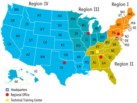
| 설명 | Map of the United States by Nuclear Regulatory Commission (NRC) Region (Now shows Mississippi in Region 4, rather than 2.) |
| 날짜 | Last revised prior to July 21, 2008 (previous: February 17, 2007) |
| 출처 | http://www.nrc.gov/images/info-finder/region-state/regions-map.gif |
| 저자 | Nuclear Regulatory Commission |
| 저작권 (이 파일을 인용하기) |
"Information generated by the NRC or developed under an NRC contract is not copyrighted, unless indicated otherwise. Non-copyrighted material can be reproduced without permission; citation of the NRC as the source of the information is appreciated." |
라이선스
| This image is a work of a Nuclear Regulatory Commission employee, taken or made as part of that person's official duties. As a work of the U.S. federal government, the image is in the public domain in the United States. |
파일 역사
날짜/시간 링크를 클릭하면 해당 시간의 파일을 볼 수 있습니다.
| 날짜/시간 | 섬네일 | 크기 | 사용자 | 설명 | |
|---|---|---|---|---|---|
| 현재 | 2008년 7월 22일 (화) 02:49 | | 550 × 415 (43 KB) | Wwoods | |
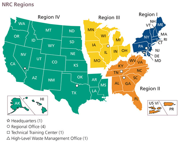
| 2007년 1월 13일 (토) 03:22 |  | 560 × 350 (23 KB) | BigrTex | {{Information |Description=Map of the United States by Nuclear Regulatory Commission (NRC) Region |Source=http://www.nrc.gov/images/info-finder/region-state/regions-map.gif |Date=Last revised Tuesday, September 20, 2005 |Author=Nuclear Regulatory Commissi |
이 파일을 사용하는 문서
다음 문서 1개가 이 파일을 사용하고 있습니다:
이 파일을 사용하고 있는 모든 위키의 문서 목록
다음 위키에서 이 파일을 사용하고 있습니다:
- de.wikipedia.org에서 이 파일을 사용하고 있는 문서 목록
- en.wikipedia.org에서 이 파일을 사용하고 있는 문서 목록
- en.wikibooks.org에서 이 파일을 사용하고 있는 문서 목록
- fr.wikipedia.org에서 이 파일을 사용하고 있는 문서 목록
- ja.wikipedia.org에서 이 파일을 사용하고 있는 문서 목록
- pl.wikipedia.org에서 이 파일을 사용하고 있는 문서 목록
- zh.wikipedia.org에서 이 파일을 사용하고 있는 문서 목록