파일:Nottinghamshire UK location map.svg

SVG 파일의 PNG 형식의 미리보기 크기: 473 × 599 픽셀. 다른 해상도: 189 × 240 픽셀 | 379 × 480 픽셀 | 606 × 768 픽셀 | 808 × 1,024 픽셀 | 1,616 × 2,048 픽셀 | 1,030 × 1,305 픽셀
원본 파일 (SVG 파일, 실제 크기 1,030 × 1,305 픽셀, 파일 크기: 1.95 MB)
| 설명 |
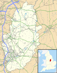
Map of Nottinghamshire, UK with the following information shown:
Equirectangular map projection on WGS 84 datum, with N/S stretched 165% Geographic limits:
|
| 날짜 | |
| 출처 |
|
| 저자 | Nilfanion, created using Ordnance Survey data |
| 저작권 (이 파일을 인용하기) |
이 파일은 크리에이티브 커먼즈 저작자표시-동일조건변경허락 3.0 Unported 라이선스로 배포됩니다. 저작자표시: Contains Ordnance Survey data © Crown copyright and database right
|
| 다른 버전 | File:Nottinghamshire UK district map (blank).svg - Blank map |
.svg)
파일 역사
날짜/시간 링크를 클릭하면 해당 시간의 파일을 볼 수 있습니다.
| 날짜/시간 | 섬네일 | 크기 | 사용자 | 설명 | |
|---|---|---|---|---|---|
| 현재 | 2010년 9월 27일 (월) 04:09 | | 1,030 × 1,305 (1.95 MB) | Nilfanion | {{Information |Description=Map of Nottinghamshire, UK with the following information shown: *Administrative borders *Coastline, lakes and rivers *Roads and railways *Urban areas Equirectangular map projection on WGS 84 datum, with N |
이 파일을 사용하는 문서
다음 문서 1개가 이 파일을 사용하고 있습니다:
이 파일을 사용하고 있는 모든 위키의 문서 목록
다음 위키에서 이 파일을 사용하고 있습니다:
- ar.wikipedia.org에서 이 파일을 사용하고 있는 문서 목록
- bg.wikipedia.org에서 이 파일을 사용하고 있는 문서 목록
- br.wikipedia.org에서 이 파일을 사용하고 있는 문서 목록
- ceb.wikipedia.org에서 이 파일을 사용하고 있는 문서 목록
- en.wikipedia.org에서 이 파일을 사용하고 있는 문서 목록
- Newstead Abbey
- Beeston, Nottinghamshire
- Blyth, Nottinghamshire
- Worksop
- Newark-on-Trent
- Edwinstowe
- Nottingham Castle
- Gotham, Nottinghamshire
- Eastwood, Nottinghamshire
- Retford
- Ollerton
- Kimberley, Nottinghamshire
- The Park Estate
- Sutton Bonington
- Queen's Medical Centre
- Calverton, Nottinghamshire
- Wollaton Hall
- Hucknall
- Arnold, Nottinghamshire
- Bircotes
- Manton, Nottinghamshire
- Scrooby
- Carlton, Nottinghamshire
- Bingham, Nottinghamshire
- West Bridgford
- Sutton-in-Ashfield
- Gamston, Rushcliffe
- Cotgrave
- RAF Syerston
- Blidworth
- Lenton, Nottingham
- Kirkby-in-Ashfield
- Tollerton, Nottinghamshire
- Rampton Secure Hospital
- Holme Pierrepont
- Zouch
- Nottingham station
- Mansfield Woodhouse
- Toton
- Redhill, Nottinghamshire
- Aslockton
- Clumber Park
- Spion Kop, Nottinghamshire
- Chilwell
- Radford, Nottingham
이 파일의 더 많은 사용 내역을 봅니다.