파일:Obcine Slovenija 2006.svg

SVG 파일의 PNG 형식의 미리보기 크기: 800 × 522 픽셀. 다른 해상도: 320 × 209 픽셀 | 640 × 418 픽셀 | 1,024 × 668 픽셀 | 1,280 × 835 픽셀 | 2,560 × 1,670 픽셀 | 2,613 × 1,705 픽셀
원본 파일 (SVG 파일, 실제 크기 2,613 × 1,705 픽셀, 파일 크기: 2.31 MB)
파일 설명
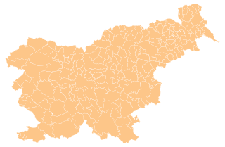
| 설명 | Map of the municipalities (občine) of the Republic of Slovenia, as since May 2006 (210 units). |
| 날짜 | |
| 출처 | Source of the public data is GURS (Geodetska uprava Republike Slovenije or Surveying and Mapping Authority of the Republic of Slovenia). Converted from Shapefile to SVG with shp2svg and prepared for Wikipedia by romanm (talk). |
| 저자 | See above. |
| 저작권 (이 파일을 인용하기) |
See Pogoji uporabe (in Slovene) and Terms and conditions (English). According to price list, which states cost 0€ for using free-of-charge published data on municipalities even for commercial purposes(!), I consider the data to be in public domain. I also hereby grant my work on this file to be in public domain. |
| 다른 버전 |
|

라이선스
| 나는 이 작품의 저작권자로서, 이 작품을 퍼블릭 도메인으로 모두에게 공개합니다. 이 공개 선언은 전 세계적으로 유효합니다. 만약 저작권의 포기가 법률적으로 가능하지 않은 경우, 나는 이 작품을 법적으로 허용되는 한도 내에서 누구나 자유롭게 어떤 목적으로도 제한없이 사용할 수 있도록 허용합니다. |
파일 역사
날짜/시간 링크를 클릭하면 해당 시간의 파일을 볼 수 있습니다.
| 날짜/시간 | 섬네일 | 크기 | 사용자 | 설명 | |
|---|---|---|---|---|---|
| 현재 | 2012년 4월 14일 (토) 01:19 | | 2,613 × 1,705 (2.31 MB) | Martin Kraft | size and display problem fixed reduced number of points |
| 2008년 11월 4일 (화) 06:32 |  | 2,613 × 1,705 (2.36 MB) | Romanm | fixed aspect ratio Category:Maps of administrative units of Slovenia | |
| 2008년 11월 4일 (화) 06:21 |  | 512 × 334 (2.36 MB) | Romanm | {{Information |Description=Map of the municipalities (''občine'') of the Republic of Slovenia, as since May 2006 (211 units). |Source=Source of [http://www.gu.gov.si/si/delovnapodrocja_gu/podatki_gu/brezplani_podatki/brezplani_podatki_obine/ the public d |
이 파일을 사용하는 문서
이 파일을 사용하는 문서가 없습니다.
이 파일을 사용하고 있는 모든 위키의 문서 목록
다음 위키에서 이 파일을 사용하고 있습니다:
- ast.wikipedia.org에서 이 파일을 사용하고 있는 문서 목록
- azb.wikipedia.org에서 이 파일을 사용하고 있는 문서 목록
- cs.wikipedia.org에서 이 파일을 사용하고 있는 문서 목록
- de.wikipedia.org에서 이 파일을 사용하고 있는 문서 목록
- eu.wikipedia.org에서 이 파일을 사용하고 있는 문서 목록
- kbd.wikipedia.org에서 이 파일을 사용하고 있는 문서 목록
- la.wikipedia.org에서 이 파일을 사용하고 있는 문서 목록
- sco.wikipedia.org에서 이 파일을 사용하고 있는 문서 목록
- sl.wikipedia.org에서 이 파일을 사용하고 있는 문서 목록
- vi.wikipedia.org에서 이 파일을 사용하고 있는 문서 목록