파일:Oceanic.Stripe.Magnetic.Anomalies.Scheme.svg

SVG 파일의 PNG 형식의 미리보기 크기: 800 × 566 픽셀. 다른 해상도: 320 × 226 픽셀 | 640 × 453 픽셀 | 1,024 × 724 픽셀 | 1,280 × 905 픽셀 | 2,560 × 1,810 픽셀 | 1,052 × 744 픽셀
원본 파일 (SVG 파일, 실제 크기 1,052 × 744 픽셀, 파일 크기: 292 KB)
파일 설명
| 설명 |
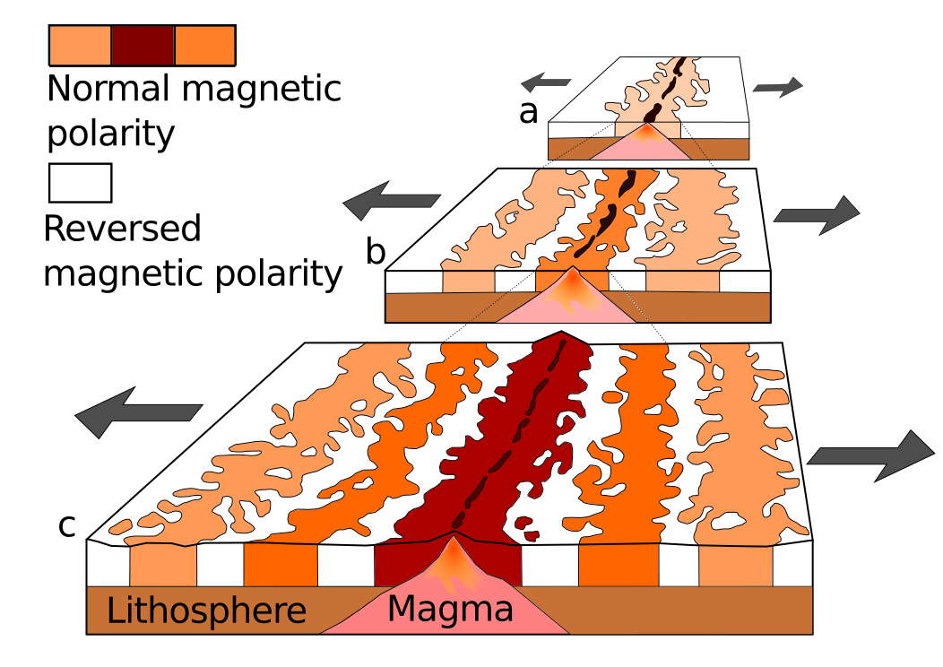
English: A theoretical model of the formation of magnetic striping. New oceanic crust forming continuously at the crest of the mid-ocean ridge cools and becomes increasingly older as it moves away from the ridge crest with seafloor spreading:
|
| 날짜 | |
| 출처 | derived from File:Oceanic.Stripe.Magnetic.Anomalies.Scheme.gif |
| 저자 | Chmee2 |
| 다른 버전 |
이 파일은 다음에 의해 파생됨: Oceanic.Stripe.Magnetic.Anomalies.Scheme.gif |
라이선스
|
|
파일 역사
날짜/시간 링크를 클릭하면 해당 시간의 파일을 볼 수 있습니다.
| 날짜/시간 | 섬네일 | 크기 | 사용자 | 설명 | |
|---|---|---|---|---|---|
| 현재 | 2022년 7월 18일 (월) 18:43 | | 1,052 × 744 (292 KB) | Pacha Tchernof | Media cleanup of perspective per request in Media for cleanup request on the page |
| 2016년 11월 6일 (일) 14:02 |  | 1,052 × 744 (257 KB) | Gorthian | Litosphere --> Lithosphere // Editing SVG source code using User:Rillke/SVGedit.js; upload handled by User:Rillke/MwJSBot.js | |
| 2012년 3월 2일 (금) 21:19 |  | 1,052 × 744 (257 KB) | Chmee2 | fix | |
| 2012년 3월 2일 (금) 21:10 |  | 1,052 × 744 (256 KB) | Chmee2 |
이 파일을 사용하는 문서
다음 문서 1개가 이 파일을 사용하고 있습니다:
이 파일을 사용하고 있는 모든 위키의 문서 목록
다음 위키에서 이 파일을 사용하고 있습니다:
- af.wikipedia.org에서 이 파일을 사용하고 있는 문서 목록
- ar.wikipedia.org에서 이 파일을 사용하고 있는 문서 목록
- az.wikipedia.org에서 이 파일을 사용하고 있는 문서 목록
- bs.wikipedia.org에서 이 파일을 사용하고 있는 문서 목록
- da.wikipedia.org에서 이 파일을 사용하고 있는 문서 목록
- de.wikipedia.org에서 이 파일을 사용하고 있는 문서 목록
- en.wikipedia.org에서 이 파일을 사용하고 있는 문서 목록
- en.wikibooks.org에서 이 파일을 사용하고 있는 문서 목록
- en.wikiversity.org에서 이 파일을 사용하고 있는 문서 목록
- es.wikipedia.org에서 이 파일을 사용하고 있는 문서 목록
- eu.wikipedia.org에서 이 파일을 사용하고 있는 문서 목록
- fa.wikipedia.org에서 이 파일을 사용하고 있는 문서 목록
- fr.wikipedia.org에서 이 파일을 사용하고 있는 문서 목록
- hr.wikipedia.org에서 이 파일을 사용하고 있는 문서 목록
- it.wikibooks.org에서 이 파일을 사용하고 있는 문서 목록
- it.wikiversity.org에서 이 파일을 사용하고 있는 문서 목록
- kn.wikipedia.org에서 이 파일을 사용하고 있는 문서 목록
- mk.wikipedia.org에서 이 파일을 사용하고 있는 문서 목록
- mr.wikipedia.org에서 이 파일을 사용하고 있는 문서 목록
- ms.wikipedia.org에서 이 파일을 사용하고 있는 문서 목록
- nds.wikipedia.org에서 이 파일을 사용하고 있는 문서 목록
- nn.wikipedia.org에서 이 파일을 사용하고 있는 문서 목록
- no.wikipedia.org에서 이 파일을 사용하고 있는 문서 목록
- pt.wikipedia.org에서 이 파일을 사용하고 있는 문서 목록
- sh.wikipedia.org에서 이 파일을 사용하고 있는 문서 목록
- sl.wikipedia.org에서 이 파일을 사용하고 있는 문서 목록
이 파일의 더 많은 사용 내역을 봅니다.