파일:Plan de Paris 1705 BNF07710700.png
미리 보기 크기: 739 × 600 픽셀 다른 해상도: 296 × 240 픽셀 | 591 × 480 픽셀 | 946 × 768 픽셀 | 1,261 × 1,024 픽셀 | 2,523 × 2,048 픽셀 | 3,890 × 3,158 픽셀
원본 파일 (3,890 × 3,158 픽셀, 파일 크기: 15.89 MB, MIME 종류: image/png)
파일 설명
| 저자 |
|
||||||||||||||||||||
| 설명 |
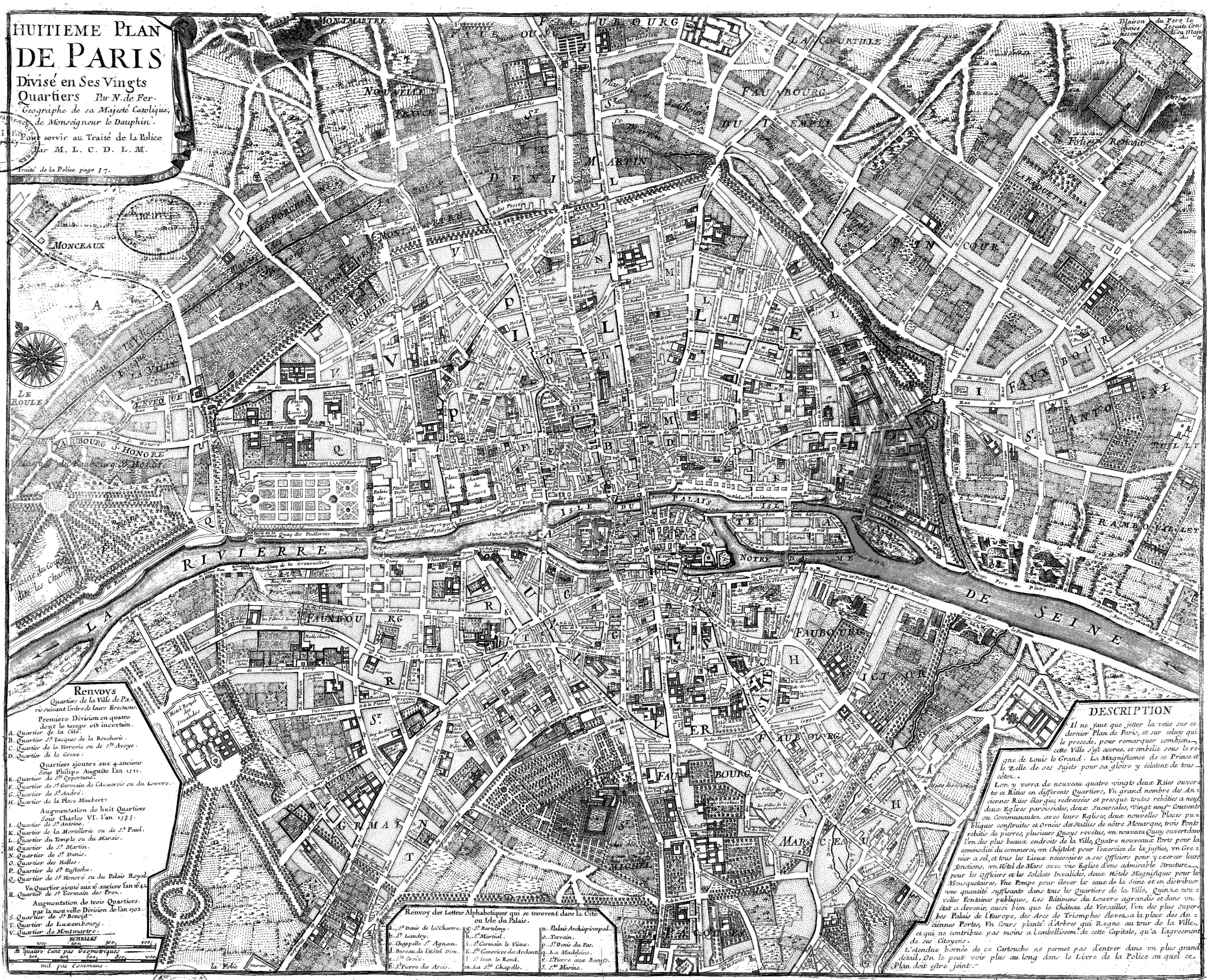
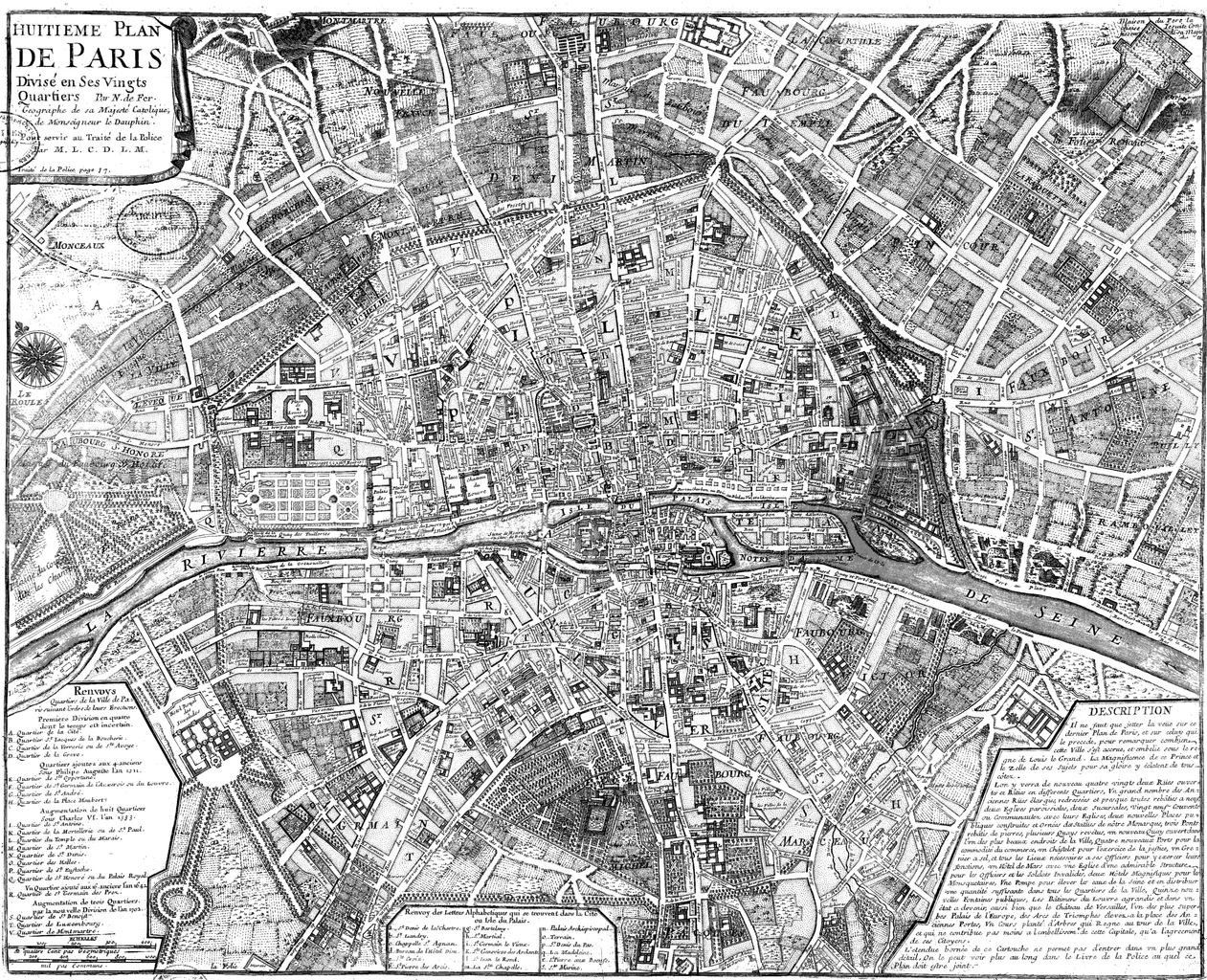
Français : Huitième plan de Paris divisé en ses vingts quartiers [Image fixe numérisée] / par N. de Fer Publication : Paris, 1705 Description matérielle : 1 carte ; 44,5 x 54,5 cm Collection : Collection d'Anville ; 00808 Note(s) : Cote : Ge DD 2987 (808) BNF Richelieu Cartes et Plans Reprod. 85 C 125661 ; Reprod. Sc 87/660 . - Légende et description en marge gauche et droite. Carte "pour servir au traité de la Police par M.L.C.D.L.M. Traité de la Police p. 87" Sujet(s) : Paris (France) -- Quartiers anciens Notice n° : FRBNF38638263 |
||||||||||||||||||||
| 날짜 | 1705년 | ||||||||||||||||||||
| 출처/촬영자 | Gallica | ||||||||||||||||||||
| 다른 버전 |
|
||||||||||||||||||||


| Open this image as an overlay in Google Earth (Google Maps, Bing) | (Help|Source) |
라이선스
|
이 작품은 미국, 그리고 저작권 보호 기간이 저작자 사후 100년, 또는 그 이하인 모든 국가에서 퍼블릭 도메인입니다. | |
| 이 저작물은 모든 저작인접권을 포함한 저작권법하의 규제로부터 자유로운 것으로 확인되었습니다. | |
| Previous public domain rationale, no longer applicable | ||
|---|---|---|
|
파일 역사
날짜/시간 링크를 클릭하면 해당 시간의 파일을 볼 수 있습니다.
| 날짜/시간 | 섬네일 | 크기 | 사용자 | 설명 | |
|---|---|---|---|---|---|
| 현재 | 2008년 6월 9일 (월) 18:20 | | 3,890 × 3,158 (15.89 MB) | Yann | reduce to below 12.5 Mpx, otherwise it will never display with Wikimedia limits. Nothing is lost (see history for the complete version, or the reference link) |
| 2005년 9월 23일 (금) 05:47 |  | 4,183 × 3,396 (2.76 MB) | David.Monniaux | Map of Paris in 1705 Type : image fixe, monographie Titre(s) : Huitième plan de Paris divisé en ses vingts quartiers [Image fixe numérisée] / par N. de Fer Publication : Paris, 1705 Description matérielle : 1 carte ; 44,5 x 54,5 cm Colle |
이 파일을 사용하는 문서
다음 문서 1개가 이 파일을 사용하고 있습니다:
이 파일을 사용하고 있는 모든 위키의 문서 목록
다음 위키에서 이 파일을 사용하고 있습니다:
- ar.wikipedia.org에서 이 파일을 사용하고 있는 문서 목록
- en.wikipedia.org에서 이 파일을 사용하고 있는 문서 목록
- fr.wikipedia.org에서 이 파일을 사용하고 있는 문서 목록
- gl.wikipedia.org에서 이 파일을 사용하고 있는 문서 목록
- he.wikipedia.org에서 이 파일을 사용하고 있는 문서 목록
- hu.wikipedia.org에서 이 파일을 사용하고 있는 문서 목록
- it.wikipedia.org에서 이 파일을 사용하고 있는 문서 목록
- ja.wikipedia.org에서 이 파일을 사용하고 있는 문서 목록
- nl.wikipedia.org에서 이 파일을 사용하고 있는 문서 목록
- pl.wikipedia.org에서 이 파일을 사용하고 있는 문서 목록
- pnb.wikipedia.org에서 이 파일을 사용하고 있는 문서 목록
- ur.wikipedia.org에서 이 파일을 사용하고 있는 문서 목록