파일:Puertoprincesa chart4343 1904.jpeg
미리 보기 크기: 715 × 600 픽셀 다른 해상도: 286 × 240 픽셀 | 572 × 480 픽셀 | 916 × 768 픽셀 | 1,221 × 1,024 픽셀 | 2,442 × 2,048 픽셀 | 3,053 × 2,561 픽셀
원본 파일 (3,053 × 2,561 픽셀, 파일 크기: 1.31 MB, MIME 종류: image/jpeg)
| 설명 |
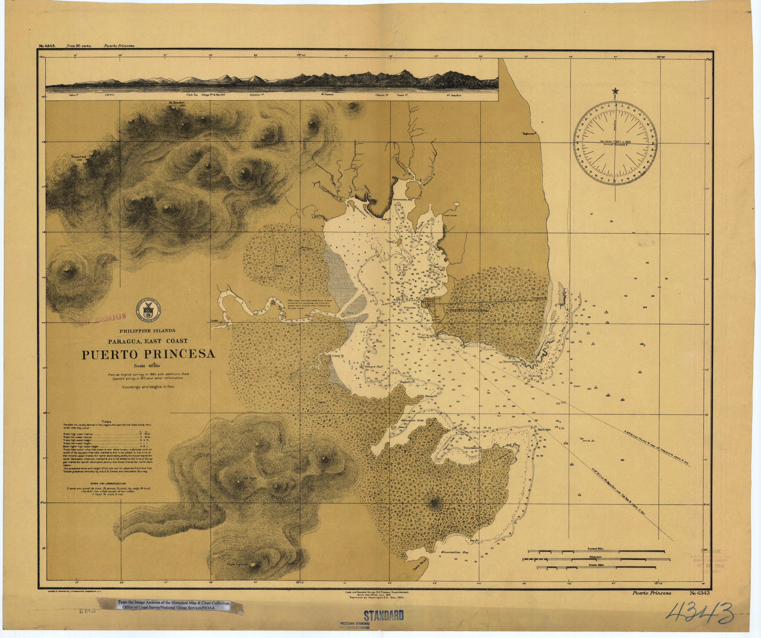
English: Scanned image of US Coast & Geodetic Survey (Manila Office) nautical chart #4343 Puerto Princesa, (Paragua), Palawan, Philippines. |
|||
| 날짜 | ||||
| 출처 |
English: From the image archives of the Historical Map & Chart Collection/Office of Coast Survey/National Ocean Service/NOAA/United States government. Converted from MrSID to JPEG format for upload to Commons. |
|||
| 저자 | Coast and Geodetic Survey O.H. Tittmann, Superintendent. Manila Sub-Office. July 1903 | |||
| 저작권 (이 파일을 인용하기) |
|
파일 역사
날짜/시간 링크를 클릭하면 해당 시간의 파일을 볼 수 있습니다.
| 날짜/시간 | 섬네일 | 크기 | 사용자 | 설명 | |
|---|---|---|---|---|---|
| 현재 | 2006년 3월 17일 (금) 10:41 | | 3,053 × 2,561 (1.31 MB) | Cdc~commonswiki | Scanned image of US Coast & Geodetic Survey (Manila Office) nautical chart #4343 Puerto Princesa, (Paragua), Palawan, Philippines, 1904. From the Image Archives of the [http://chartmaker.ncd.noaa.gov/csdl/ctp/abstract.htm Historical Map & Chart Collecti |
이 파일을 사용하는 문서
다음 문서 1개가 이 파일을 사용하고 있습니다:
이 파일을 사용하고 있는 모든 위키의 문서 목록
다음 위키에서 이 파일을 사용하고 있습니다:
- en.wikipedia.org에서 이 파일을 사용하고 있는 문서 목록
- es.wikipedia.org에서 이 파일을 사용하고 있는 문서 목록
- ja.wikipedia.org에서 이 파일을 사용하고 있는 문서 목록
- ka.wikipedia.org에서 이 파일을 사용하고 있는 문서 목록
- pam.wikipedia.org에서 이 파일을 사용하고 있는 문서 목록
- pt.wikipedia.org에서 이 파일을 사용하고 있는 문서 목록
- tl.wikipedia.org에서 이 파일을 사용하고 있는 문서 목록