파일:Putrajaya from the Sky (Unsplash).jpg

미리 보기 크기: 360 × 600 픽셀 다른 해상도: 144 × 240 픽셀 | 288 × 480 픽셀 | 461 × 768 픽셀 | 615 × 1,024 픽셀 | 1,229 × 2,048 픽셀 | 3,107 × 5,175 픽셀
원본 파일 (3,107 × 5,175 픽셀, 파일 크기: 3.91 MB, MIME 종류: image/jpeg)
.jpg?uselang=ko)
파일 설명
| 설명 |
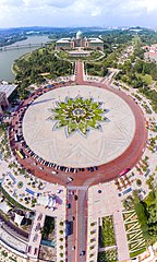
English: Putrajaya is a city in Malaysia, south of Kuala Lumpur. It’s known for its late-20th-century architecture including the Putra Mosque, made from rose-colored granite with a pink dome. Nearby is the immense, green-domed Perdana Putra, which contains the prime minister’s office complex. The 3-tiered Putra Bridge is inspired by Iranian architecture, with 4 minaret-type piers overlooking the man-made Putrajaya Lake. |
| 날짜 | |
| 출처 | https://unsplash.com/photos/CeX1Cl_ZLHk |
| 저자 | Ishan @seefromthesky seefromthesky |
| Unsplash title | Putrajaya from the Sky |
| Unsplash description | Putrajaya is a city in Malaysia, south of Kuala Lumpur. It’s known for its late-20th-century architecture including the Putra Mosque, made from rose-colored granite with a pink dome. Nearby is the immense, green-domed Perdana Putra, which contains the prime minister’s office complex. The 3-tiered Putra Bridge is inspired by Iranian architecture, with 4 minaret-type piers overlooking the man-made Putrajaya Lake. |
| Categories | awesome |
| EXIF | exposure_time: 1/4000 · make: DJI · iso: 100 · focal_length: 3.6 · aperture: 2.8 · model: FC330 |
| Place | Kuala Lumpur, Malaysia |
| 카메라 위치 | | 이 지역의 다른 사진을 보기: OpenStreetMap |
|---|
.jpg¶ms=002.933598_N_0101.691752_E_globe:Earth_type:camera__&language=ko)
라이선스

|
This image is from Unsplash and was published prior to 5 June 2017 under the Creative Commons CC0 1.0 Universal Public Domain Dedication. Note: On 2017년 6월 5일, Unsplash switched the old sitewide license for all uploads from Creative Commons CC0 to a custom license arrangement which does not meet the free content licensing requirements for Commons. Therefore, media published on Unsplash from 2017년 6월 5일 onwards is not considered to be freely licensed and can't be accepted on Commons. Files uploaded to Commons after this date should be subject to careful license review, verifying that the publication date on Unsplash is prior to 2017년 6월 5일.
|
| 이 파일은 크리에이티브 커먼즈 CC0 1.0 보편적 퍼블릭 도메인 귀속에 따라 이용할 수 있습니다. | |
| 저작물에 본 권리증서를 첨부한 자는 법률에서 허용하는 범위 내에서 저작인접권 및 관련된 모든 권리들을 포함하여 저작권법에 따라 전 세계적으로 해당 저작물에 대해 자신이 갖는 일체의 권리를 포기함으로써 저작물을 퍼블릭 도메인으로 양도하였습니다. 저작권자의 허락을 구하지 않아도 이 저작물을 상업적인 목적을 포함하여 모든 목적으로 복제, 수정·변경, 배포, 공연·실연할 수 있습니다.
|
파일 역사
날짜/시간 링크를 클릭하면 해당 시간의 파일을 볼 수 있습니다.
| 날짜/시간 | 섬네일 | 크기 | 사용자 | 설명 | |
|---|---|---|---|---|---|
| 현재 | 2018년 4월 5일 (목) 20:00 | | 3,107 × 5,175 (3.91 MB) | *angys* | User created page with UploadWizard |
이 파일을 사용하는 문서
다음 문서 1개가 이 파일을 사용하고 있습니다:
이 파일을 사용하고 있는 모든 위키의 문서 목록
다음 위키에서 이 파일을 사용하고 있습니다:
- en.wikipedia.org에서 이 파일을 사용하고 있는 문서 목록
.jpg)