파일:Qatar 31 January 2003.jpg

원본 파일 (1,110 × 1,375 픽셀, 파일 크기: 656 KB, MIME 종류: image/jpeg)
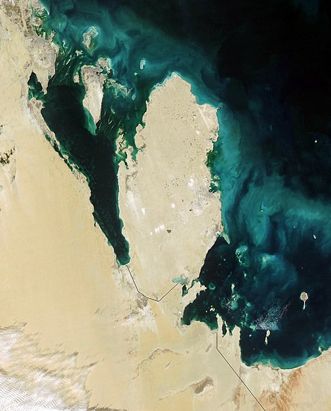
Qatar
This true-color Moderate Resolution Imaging Spectroradiometer (MODIS) image from January 31, 2003, featuresthe Persian Gulf in the Middle East. Seven countries sit on the Gulf(clockwise from top right): Iran, Oman, the United Arab Emirates, SaudiArabia, Qatar, Kuwait, and Iraq. In addition to the tip of the peninsulareaching toward Iran, Oman also stretches to the southeast along the Gulfof Oman (bottom right corner).
The Persian Gulf, officially known as The Gulf, features clouds ofblue and green in its dark waters. These clouds likely indicate a mixtureof sediment and microscopic marine plant life. At the top of The Gulf,where Kuwait, Iraq, and Iran meet, two rivers flow into the Gulf and addtan streaks to the water. These rivers are the Euphrates and the Tigris,the source of the Fertile Crescent valley and between which the ancientMesopotamian civilization flourished.
A number of fires were detected in this scene by MODIS and are markedin red. They are concentrated in southern Iraq and western Iran. The onesin southern Iraq are likely associated with oil wells. Snow can also beseen blanketing the Zagros Mountains of Iran at the upper center of theimage.
http://visibleearth.nasa.gov/view_rec.php?id=4981
| 이 파일은 NASA에서 제작하였으므로 퍼블릭 도메인입니다. NASA의 저작권 정책에 따르면 NASA의 자료는 명시하지 않는 이상 저작권의 보호를 받지 않습니다. (Template:PD-USGov, 또는 NASA 저작권 정책 문서, JPL 그림 사용 정책을 참고하세요.) | ||
 |
주의사항:
|
.jpg)
파일 역사
날짜/시간 링크를 클릭하면 해당 시간의 파일을 볼 수 있습니다.
| 날짜/시간 | 섬네일 | 크기 | 사용자 | 설명 | |
|---|---|---|---|---|---|
| 현재 | 2005년 10월 26일 (수) 15:39 | | 1,110 × 1,375 (656 KB) | Brian0918 | Qatar This true-color Moderate Resolution Imaging Spectroradiometer (MODIS) image from January 31, 2003, featuresthe Persian Gulf in the Middle East. Seven countries sit on the Gulf(clockwise from top right): Iran, Oman, the United Arab Emirates, SaudiAr |
이 파일을 사용하는 문서
다음 문서 1개가 이 파일을 사용하고 있습니다:
이 파일을 사용하고 있는 모든 위키의 문서 목록
다음 위키에서 이 파일을 사용하고 있습니다:
- ar.wikipedia.org에서 이 파일을 사용하고 있는 문서 목록
- az.wikipedia.org에서 이 파일을 사용하고 있는 문서 목록
- bcl.wikipedia.org에서 이 파일을 사용하고 있는 문서 목록
- bn.wikipedia.org에서 이 파일을 사용하고 있는 문서 목록
- ca.wikipedia.org에서 이 파일을 사용하고 있는 문서 목록
- ceb.wikipedia.org에서 이 파일을 사용하고 있는 문서 목록
- de.wikivoyage.org에서 이 파일을 사용하고 있는 문서 목록
- el.wikipedia.org에서 이 파일을 사용하고 있는 문서 목록
- en.wikipedia.org에서 이 파일을 사용하고 있는 문서 목록
- en.wikivoyage.org에서 이 파일을 사용하고 있는 문서 목록
- es.wikipedia.org에서 이 파일을 사용하고 있는 문서 목록
- fi.wikipedia.org에서 이 파일을 사용하고 있는 문서 목록
- fr.wikipedia.org에서 이 파일을 사용하고 있는 문서 목록
- he.wikipedia.org에서 이 파일을 사용하고 있는 문서 목록
- he.wikivoyage.org에서 이 파일을 사용하고 있는 문서 목록
- hr.wikipedia.org에서 이 파일을 사용하고 있는 문서 목록
- it.wikipedia.org에서 이 파일을 사용하고 있는 문서 목록
- it.wikivoyage.org에서 이 파일을 사용하고 있는 문서 목록
- ja.wikipedia.org에서 이 파일을 사용하고 있는 문서 목록
- mn.wikipedia.org에서 이 파일을 사용하고 있는 문서 목록
- nl.wikipedia.org에서 이 파일을 사용하고 있는 문서 목록
- nn.wikipedia.org에서 이 파일을 사용하고 있는 문서 목록
- pl.wikipedia.org에서 이 파일을 사용하고 있는 문서 목록
- pt.wikipedia.org에서 이 파일을 사용하고 있는 문서 목록
- ru.wikipedia.org에서 이 파일을 사용하고 있는 문서 목록
- sh.wikipedia.org에서 이 파일을 사용하고 있는 문서 목록
- sv.wikipedia.org에서 이 파일을 사용하고 있는 문서 목록
- tl.wikipedia.org에서 이 파일을 사용하고 있는 문서 목록
- uk.wikipedia.org에서 이 파일을 사용하고 있는 문서 목록
- www.wikidata.org에서 이 파일을 사용하고 있는 문서 목록