파일:SBIRS-GEO.jpg
최대 해상도입니다.
SBIRS-GEO.jpg (265 × 190 픽셀, 파일 크기: 25 KB, MIME 종류: image/jpeg)
| 설명 |
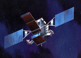
English: SPACE BASED INFRARED SYSTEMS (SBIRS)
SBIRS High features a mix of four geosynchronous earth orbit (GEO) satellites, two highly elliptical earth orbit (HEO) payloads, and associated ground hardware and software. SBIRS High will have both improved sensor flexibility and sensitivity. Sensors will cover short-wave infrared like its predecessor, expanded mid-wave infrared and see-to-the-ground bands allowing it to perform a broader set of missions as compared to DSP. Currently in the engineering, manufacturing, and development phase, the first SBIRS High HEO payload is scheduled for delivery in 2003 and the first GEO satellite is expected to launch in 2006 |
| 출처 | http://www.losangeles.af.mil/library/factsheets/factsheet_media.asp?fsID=5330 |
| 저자 | US Air Force |
|
|
 |
파일 역사
날짜/시간 링크를 클릭하면 해당 시간의 파일을 볼 수 있습니다.
| 날짜/시간 | 섬네일 | 크기 | 사용자 | 설명 | |
|---|---|---|---|---|---|
| 현재 | 2008년 6월 22일 (일) 19:21 | | 265 × 190 (25 KB) | GDK | {{Information |Description={{en|1=SPACE BASED INFRARED SYSTEMS (SBIRS) SBIRS High features a mix of four geosynchronous earth orbit (GEO) satellites, two highly elliptical earth orbit (HEO) payloads, and associated ground hardware and software. SBIRS High |
이 파일을 사용하는 문서
다음 문서 2개가 이 파일을 사용하고 있습니다:
이 파일을 사용하고 있는 모든 위키의 문서 목록
다음 위키에서 이 파일을 사용하고 있습니다:
- de.wikipedia.org에서 이 파일을 사용하고 있는 문서 목록
- en.wikipedia.org에서 이 파일을 사용하고 있는 문서 목록
- et.wikipedia.org에서 이 파일을 사용하고 있는 문서 목록
- it.wikipedia.org에서 이 파일을 사용하고 있는 문서 목록
- ja.wikipedia.org에서 이 파일을 사용하고 있는 문서 목록
- pt.wikipedia.org에서 이 파일을 사용하고 있는 문서 목록
- ru.wikipedia.org에서 이 파일을 사용하고 있는 문서 목록
- tr.wikipedia.org에서 이 파일을 사용하고 있는 문서 목록
- uk.wikipedia.org에서 이 파일을 사용하고 있는 문서 목록