파일:SaintDomingue.360.jpg
미리 보기 크기: 773 × 600 픽셀 다른 해상도: 310 × 240 픽셀 | 619 × 480 픽셀 | 990 × 768 픽셀 | 1,280 × 993 픽셀 | 2,560 × 1,986 픽셀 | 5,931 × 4,601 픽셀
원본 파일 (5,931 × 4,601 픽셀, 파일 크기: 12.27 MB, MIME 종류: image/jpeg)
파일 설명
| 설명 |
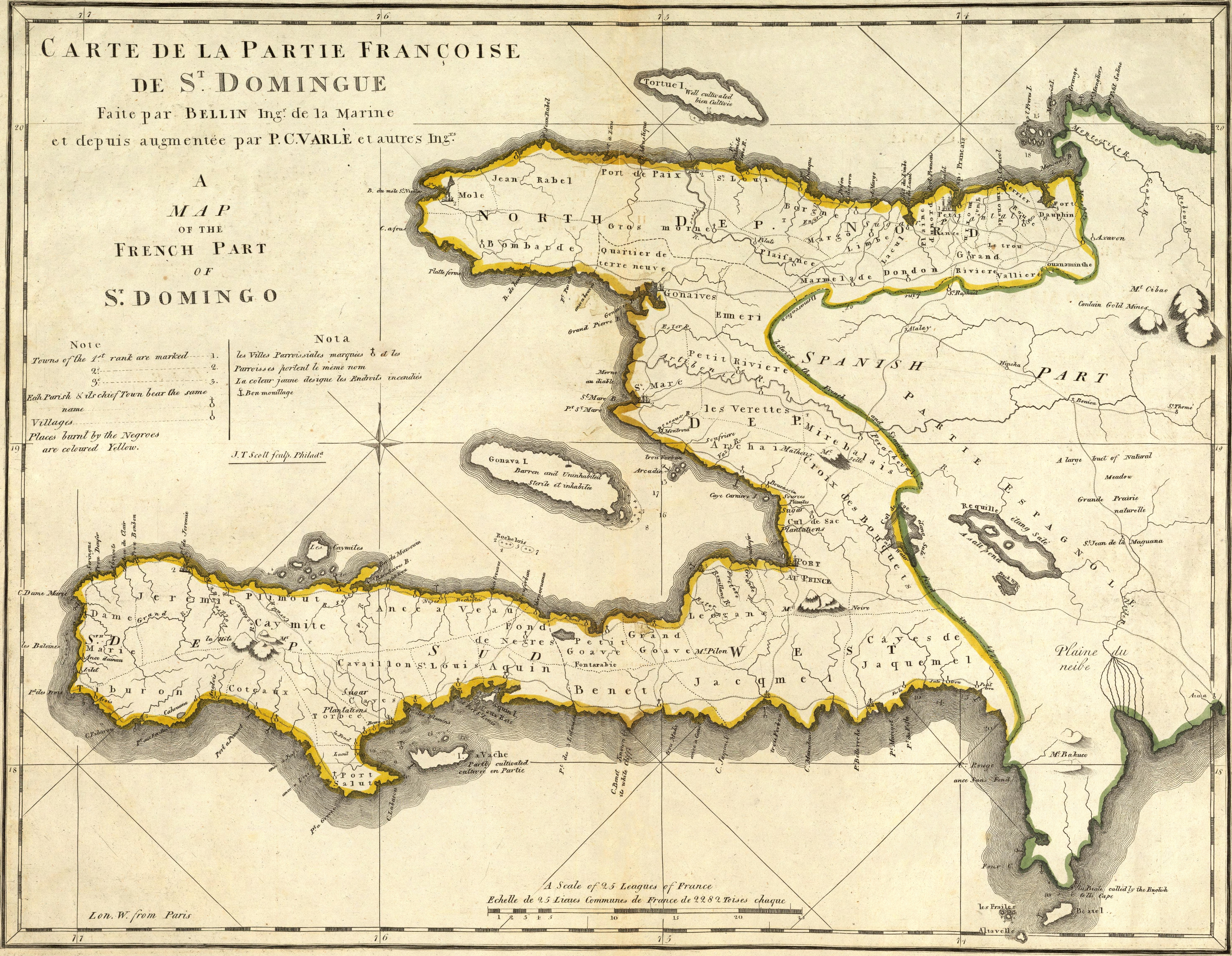
English: Map of French part of Saint Domingue (Haiti).
Français : Carte de la partie française de Saint-Domingue.
|
| 날짜 | |
| 출처 | https://www.davidrumsey.com/luna/servlet/detail/RUMSEY~8~1~640~50079:Carte-De-La-Partie-Francoise-De-St-?sort=Pub_List_No_InitialSort%2CPub_Date%2CPub_List_No%2CSeries_No# |
| 저자 | Mathew Carey (engravers/printers: Bellin, Jacques Nicolas, 1703-1772; Scott, Joseph T.; Varle, P.C.) |
라이선스
|
이 작품은 미국, 그리고 저작권 보호 기간이 저작자 사후 100년, 또는 그 이하인 모든 국가에서 퍼블릭 도메인입니다. | |
| 이 저작물은 모든 저작인접권을 포함한 저작권법하의 규제로부터 자유로운 것으로 확인되었습니다. | |
파일 역사
날짜/시간 링크를 클릭하면 해당 시간의 파일을 볼 수 있습니다.
| 날짜/시간 | 섬네일 | 크기 | 사용자 | 설명 | |
|---|---|---|---|---|---|
| 현재 | 2021년 11월 6일 (토) 09:11 | | 5,931 × 4,601 (12.27 MB) | SyntaxTerror | very high res., cleaned, contrast |
| 2021년 11월 6일 (토) 08:46 |  | 1,200 × 929 (504 KB) | SyntaxTerror | higher resolution, artifacts removed, cleaned, lighting/contrast (original from http://www.davidrumsey.com/rumsey/Size4/D0005/00054079.jpg) | |
| 2007년 12월 31일 (월) 20:46 |  | 360 × 281 (43 KB) | JoseREMY | {{Information |Description=Map of french part of Saint Domingue |Source=French public archives |Date=1789 |Author=Bellin and P. C. Varle |Permission=Public domain |other_versions=no }} |
이 파일을 사용하는 문서
다음 문서 1개가 이 파일을 사용하고 있습니다:
이 파일을 사용하고 있는 모든 위키의 문서 목록
다음 위키에서 이 파일을 사용하고 있습니다:
- br.wikipedia.org에서 이 파일을 사용하고 있는 문서 목록
- cs.wikipedia.org에서 이 파일을 사용하고 있는 문서 목록
- da.wikipedia.org에서 이 파일을 사용하고 있는 문서 목록
- de.wikipedia.org에서 이 파일을 사용하고 있는 문서 목록
- en.wikipedia.org에서 이 파일을 사용하고 있는 문서 목록
- en.wiktionary.org에서 이 파일을 사용하고 있는 문서 목록
- fi.wikipedia.org에서 이 파일을 사용하고 있는 문서 목록
- fr.wikipedia.org에서 이 파일을 사용하고 있는 문서 목록
- ht.wikipedia.org에서 이 파일을 사용하고 있는 문서 목록
- hu.wikipedia.org에서 이 파일을 사용하고 있는 문서 목록
- it.wikipedia.org에서 이 파일을 사용하고 있는 문서 목록
- ja.wikipedia.org에서 이 파일을 사용하고 있는 문서 목록
- nl.wikipedia.org에서 이 파일을 사용하고 있는 문서 목록
- no.wikipedia.org에서 이 파일을 사용하고 있는 문서 목록
- pl.wikipedia.org에서 이 파일을 사용하고 있는 문서 목록
- pt.wikipedia.org에서 이 파일을 사용하고 있는 문서 목록
- ru.wikipedia.org에서 이 파일을 사용하고 있는 문서 목록
- simple.wikipedia.org에서 이 파일을 사용하고 있는 문서 목록
- ta.wikipedia.org에서 이 파일을 사용하고 있는 문서 목록
- th.wikipedia.org에서 이 파일을 사용하고 있는 문서 목록
- uk.wikipedia.org에서 이 파일을 사용하고 있는 문서 목록
- vi.wikipedia.org에서 이 파일을 사용하고 있는 문서 목록
- zh.wiktionary.org에서 이 파일을 사용하고 있는 문서 목록