파일:Seas of the Philippines.svg

SVG 파일의 PNG 형식의 미리보기 크기: 318 × 600 픽셀. 다른 해상도: 127 × 240 픽셀 | 254 × 480 픽셀 | 407 × 768 픽셀 | 543 × 1,024 픽셀 | 1,086 × 2,048 픽셀 | 2,106 × 3,971 픽셀
원본 파일 (SVG 파일, 실제 크기 2,106 × 3,971 픽셀, 파일 크기: 517 KB)
파일 설명
| 설명 |
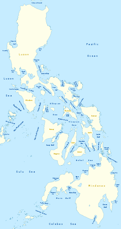
Deutsch: Karte der Seegewässer der Philippinen
English: Map of seas of the Philippines |
|
| 날짜 | ||
| 출처 | 자작, using United States National Imagery and Mapping Agency data | |
| 저자 | NordNordWest | |
| 저작권 (이 파일을 인용하기) |
이 파일은 크리에이티브 커먼즈 저작자표시-동일조건변경허락 3.0 독일 라이선스로 배포됩니다.
 이 파일은 크리에이티브 커먼즈 저작자표시-동일조건변경허락 3.0 Unported 라이선스로 배포됩니다.
|
|
| 다른 버전 |
|


|
This map has been made or improved in the German Kartenwerkstatt (Map Lab). You can propose maps to improve as well.
|
파일 역사
날짜/시간 링크를 클릭하면 해당 시간의 파일을 볼 수 있습니다.
| 날짜/시간 | 섬네일 | 크기 | 사용자 | 설명 | |
|---|---|---|---|---|---|
| 현재 | 2011년 2월월 15일 (화) 06:25 | | 2,106 × 3,971 (517 KB) | NordNordWest | == {{int:filedesc}} == {{Information |Description= {{de|Karte der Seegewässer der Philippinen}} {{en|Map of seas of the Philippines}} |Source={{Own}}, using United States National Imagery and Mapping Agency data |Date=2012-02-14 |Author={{U|NordNordWest |
이 파일을 사용하는 문서
다음 문서 18개가 이 파일을 사용하고 있습니다:
이 파일을 사용하고 있는 모든 위키의 문서 목록
다음 위키에서 이 파일을 사용하고 있습니다:
- de.wikipedia.org에서 이 파일을 사용하고 있는 문서 목록
- en.wikipedia.org에서 이 파일을 사용하고 있는 문서 목록
- South China Sea
- Luzon Strait
- Leyte Gulf
- Philippine Sea
- Canigao Channel
- Cebu Strait
- Sulu Sea
- Moro Gulf
- Davao Gulf
- Panay Gulf
- Bohol Sea
- Lingayen Gulf
- Surigao Strait
- Celebes Sea
- Sibuyan Sea
- Visayan Sea
- San Juanico Strait
- San Bernardino Strait
- Balintang Channel
- Camotes Sea
- Samar Sea
- Ragay Gulf
- Lagonoy Gulf
- Sorsogon Bay
- Albay Gulf
- Tablas Strait
- Mindoro Strait
- Balabac Strait
- Verde Island Passage
- Sibutu Passage
- Jintotolo Channel
- Tañon Strait
- Dinagat Sound
- Template:List of Philippine seas
- Iloilo Strait
- Guimaras Strait
- Basilan Strait
- Maqueda Channel
- Burias Pass
- Ticao Pass
- Portal:Oceans
- ilo.wikipedia.org에서 이 파일을 사용하고 있는 문서 목록
이 파일의 더 많은 사용 내역을 봅니다.