파일:Seram en.png

미리 보기 크기: 800 × 382 픽셀 다른 해상도: 320 × 153 픽셀 | 640 × 306 픽셀 | 1,024 × 489 픽셀 | 1,280 × 612 픽셀 | 2,756 × 1,317 픽셀
원본 파일 (2,756 × 1,317 픽셀, 파일 크기: 2.59 MB, MIME 종류: image/png)
파일 설명
| 설명 | |
| 날짜 | |
| 출처 |
own work, used:
|
| 저자 | Lencer |
| 다른 버전 |
|


|
This map has been made or improved in the German Kartenwerkstatt (Map Lab). You can propose maps to improve as well.
|
라이선스
나는 아래 작품의 저작권자로서, 이 저작물을 다음과 같은 라이선스로 배포합니다:
이 파일은 크리에이티브 커먼즈 저작자표시-동일조건변경허락 3.0 Unported 라이선스로 배포됩니다.
- 이용자는 다음의 권리를 갖습니다:
- 공유 및 이용 – 저작물의 복제, 배포, 전시, 공연 및 공중송신
- 재창작 – 저작물의 개작, 수정, 2차적저작물 창작
- 다음과 같은 조건을 따라야 합니다:
- 저작자표시 – 적절한 저작자 표시를 제공하고, 라이센스에 대한 링크를 제공하고, 변경사항이 있는지를 표시해야 합니다. 당신은 합리적인 방식으로 표시할 수 있지만, 어떤 방식으로든 사용권 허가자가 당신 또는 당신의 사용을 지지하는 방식으로 표시할 수 없습니다.
- 동일조건변경허락 – 만약 당신이 이 저작물을 리믹스 또는 변형하거나 이 저작물을 기반으로 제작하는 경우, 당신은 당신의 기여물을 원저작물과 동일하거나 호환 가능한 라이선스에 따라 배포하여야 합니다.
파일 역사
날짜/시간 링크를 클릭하면 해당 시간의 파일을 볼 수 있습니다.
| 날짜/시간 | 섬네일 | 크기 | 사용자 | 설명 | |
|---|---|---|---|---|---|
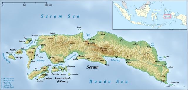
| 현재 | 2015년 6월 18일 (목) 14:05 | | 2,756 × 1,317 (2.59 MB) | Lencer | small fix |
| 2015년 6월 17일 (수) 15:22 |  | 2,756 × 1,317 (2.59 MB) | Lencer | small fixes | |
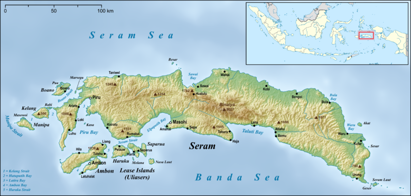
| 2015년 6월 17일 (수) 14:42 |  | 2,756 × 1,317 (2.59 MB) | Lencer | == {{int:filedesc}} == {{Information |Description= {{en|Map of Seram Island and also Ambon Island and Lease Islands}} {{de|Karte der Insel Seram, sowie [[:de:Ambon (Insel)|Am... |
이 파일을 사용하는 문서
다음 문서 1개가 이 파일을 사용하고 있습니다:
이 파일을 사용하고 있는 모든 위키의 문서 목록
다음 위키에서 이 파일을 사용하고 있습니다:
- af.wikipedia.org에서 이 파일을 사용하고 있는 문서 목록
- ar.wikipedia.org에서 이 파일을 사용하고 있는 문서 목록
- ast.wikipedia.org에서 이 파일을 사용하고 있는 문서 목록
- be.wikipedia.org에서 이 파일을 사용하고 있는 문서 목록
- bg.wikipedia.org에서 이 파일을 사용하고 있는 문서 목록
- bn.wikipedia.org에서 이 파일을 사용하고 있는 문서 목록
- ca.wikipedia.org에서 이 파일을 사용하고 있는 문서 목록
- ceb.wikipedia.org에서 이 파일을 사용하고 있는 문서 목록
- cs.wikipedia.org에서 이 파일을 사용하고 있는 문서 목록
- cy.wikipedia.org에서 이 파일을 사용하고 있는 문서 목록
- da.wikipedia.org에서 이 파일을 사용하고 있는 문서 목록
- de.wikipedia.org에서 이 파일을 사용하고 있는 문서 목록
- el.wikipedia.org에서 이 파일을 사용하고 있는 문서 목록
- en.wikipedia.org에서 이 파일을 사용하고 있는 문서 목록
- Seram Island
- Pattimura International Airport
- Streak-breasted fantail
- Central Maluku Regency
- West Seram Regency
- East Seram Regency
- Masohi
- Tehoru
- Boano
- Masiwang River
- Kawa River
- Sapalewa River
- Tala River
- Salawai River
- Banggoi
- Bula, Indonesia
- Taniwel
- Piru, Indonesia
- Kairatu
- Ariate
- Luhu, Indonesia
- Kulur, Indonesia
- Loki, Indonesia
- Module:Location map/data/Indonesia Seram/doc
- Amahai
- Atiahu
- Bemu
- Wikipedia:Graphics Lab/Map workshop/Archive/Jun 2015
이 파일의 더 많은 사용 내역을 봅니다.