파일:Swisstopo Eiger - Grindelwald.jpg

미리 보기 크기: 800 × 534 픽셀 다른 해상도: 320 × 213 픽셀 | 640 × 427 픽셀 | 1,024 × 683 픽셀 | 1,280 × 854 픽셀 | 1,537 × 1,025 픽셀
원본 파일 (1,537 × 1,025 픽셀, 파일 크기: 783 KB, MIME 종류: image/jpeg)
파일 설명
| 설명 |
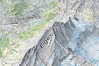
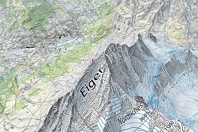
English: Screen capture taken on the geographical portal map.geo.admin.ch, displaying the 1:25'000 Swiss national map along with terrain elevation (3D rendering). The map (centered on the Eiger) shows various terrain types (settlements, rivers, forests, open areas, rocks and glaciers) and elevations, from about 1,000 metres above sea level to about 4,000 metres above sea level. |
|||||||||||||||||||||||
| 날짜 | ||||||||||||||||||||||||
| 출처 |
|
|||||||||||||||||||||||
| 저자 |
|
|||||||||||||||||||||||

라이선스
The data made publicly available by swisstopo may be used, distributed and made accessible. Furthermore, they may be enriched and processed and also used commercially. A reference to the source is mandatory. In the case of digital or analogue representations and publications, as well as in the case of dissemination, one of the following source references must be attached in any case:
Terms of use for free geodata and geoservices (OGD) from swisstopo
|
.svg) |
파일 역사
날짜/시간 링크를 클릭하면 해당 시간의 파일을 볼 수 있습니다.
| 날짜/시간 | 섬네일 | 크기 | 사용자 | 설명 | |
|---|---|---|---|---|---|
| 현재 | 2021년 3월 29일 (월) 23:30 | | 1,537 × 1,025 (783 KB) | Zacharie Grossen | Uploaded a work by Bundesamt für Landestopografie swisstopo from [https://map.geo.admin.ch/ Swisstopo maps on the geographical portal] with UploadWizard |
이 파일을 사용하는 문서
다음 문서 1개가 이 파일을 사용하고 있습니다:
이 파일을 사용하고 있는 모든 위키의 문서 목록
다음 위키에서 이 파일을 사용하고 있습니다:
- en.wikipedia.org에서 이 파일을 사용하고 있는 문서 목록
- fr.wikipedia.org에서 이 파일을 사용하고 있는 문서 목록
- oc.wikipedia.org에서 이 파일을 사용하고 있는 문서 목록