성전산
성전산(聖殿山, 히브리어: הַר הַבַּיִת,아랍어: الحرم القدسي الشريف)은 예루살렘 구시가에 있는 종교적 성지이다. 유대교에서 가장 신성한 지역이다. 유대인의 예루살렘 성전이 이곳에 위치해 있다:제1성전(솔로몬 성전)은 기원전 967년에 지어져서 기원전 586년까지 존재했다. 제2성전은 기원전 515년에 지어져서, 70년까지 존재하였다. 유대교에서는 메시야가 오면 이곳에 제3성전이 지어질 것으로 믿는다.
| 성전산(聖殿山) | |
|---|---|
| Temple Mount | |
-Aerial-Temple_Mount-(south_exposure).jpg) | |
| 최고점 | |
| 고도 | 743 m (2,438 ft) |
| 지리 | |
| 위치 | 예루살렘 |
사진
편집-
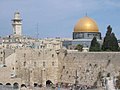 통곡의 벽과 성전산
 -
 수석(首席)랍비의 경고판, 성전산 진입시의 금지사항
 -


성경 신학자들은 다음의 두 산을 이 곳으로 여긴다.
하나님께서 영광(Shekhinah)이 머물기로 선택하신 곳이다.(이사야 8:18) 유대 전승인 탈무드에 따르면 최초의 인간 아담을 흙으로 빚으신 곳이다 증거가 없는 솔로몬 성전을 비롯한 유대교의 역사상 두 성전이 있던 곳이다.[1] 성경에 따르면, 국가의 중심지 기능을 하는 장소다. 즉, 정부, 사법, 종교의 중심지다.(신명기 12:5-26; 14:23-25; 15:20; 16:2-16; 17:8-10; 26: 2; 31: 11; 이사야 2: 2-5; 오바댜 1:21; 시편 48). 제2성전 시대에는 경제적 중심지이기도 했다. 이곳에서 하나님의 말씀이 열방(all nations)으로 선포되며, 모든 기도가 포커스(fucus)되는 곳이다.(역대하 3:1-2) 유대교에서 가장 성스러운 장소(the holiest site)이자 기도하는 곳이다. 랍비법에 따라 많은 유대인들은 지성소(Holy of Holies)를 무의식적으로 밟지 않고자 성전산 위를 걷지 않는다.[2] 지성소는 대제사장(High Priest)이 하나님과 직접 교제하는 곳이다.
- 솔로몬 성전(제1성전): 다윗의 아들 솔로몬(Solomon)이 기원전 957년에 짓고, 기원전 586년에 바벨론에 의해 파괴되었다.
- 제2성전: 스룹바벨(Zerubbabel)이 기원전 516년 짓고, AD 70년에 로마제국(Roman Empire)에 의해 파괴되었다.
- 제3성전(마지막 성전): 유대 전통에 의해 지어질 예정이다.
수니파(Sunni Muslims) 이슬람교도들은 널리 이 산을 이슬람교의 3번째 성지(the third holiest site in Islam)로 여긴다.[3][4][5][6][7][8][9][10]
위치
편집
[11][12][13][14][15][16] 성전산 북쪽 벽은, 서벽 북쪽 구역과 함께, 거주지역 안에 숨겨져 있다. 서쪽 프랭크(flank)의 남쪽 구역은 서벽(Western Wall)으로 알려졌다.[17]

각주
편집- ↑ BBC Science and Nature
- ↑ Maimonides, Mishneh Torah, Avoda (Divine Service): The laws of the Temple in Jerusalem, chapter 6, rule 14
- ↑ Nicolle, David (1994). Yarmuk AD 636: The Muslim Conquest of Syria. Osprey Publishing.
- ↑ The Dome was completed in 692 CE, making it one of the oldest extant Islamic structures in the world, after the Kaabah. The Al Aqsa Mosque rests on the far southern side of the Mount, facing Mecca. The Dome of the Rock currently sits in the middle, occupying or close to the area where the Bible mandates the Holy Temple be rebuilt.
- ↑ Rizwi Faizer (1998). “The Shape of the Holy: Early Islamic Jerusalem”. Rizwi's Bibliography for Medieval Islam. 2002년 2월 10일에 원본 문서에서 보존된 문서.
- ↑ In light of the dual claims of both Judaism and Islam, it is one of the most contested religious sites in the world. Since the Crusades, the Muslim community of Jerusalem has managed the site as a Waqf, without interruption.
- ↑ Haram al-Sharif Archived 2011년 9월 24일 - 웨이백 머신, ArchNet
- ↑ As the site is part of the Old City, controlled by Israel since 1967, both Israel and the Palestinian Authority claim sovereignty over it, and it remains a major focal point of the Arab–Israeli conflict.
- ↑ “Israeli Police Storm Disputed Jerusalem Holy Site”. 2009년 10월 31일에 원본 문서에서 보존된 문서. 2016년 2월 6일에 확인함.
- ↑ In an attempt to keep the status quo, the Israeli government enforces a controversial ban on prayer by non-Muslim visitors.
- ↑ The Temple Mount forms the northern portion of a very narrow spur of hill that slopes sharply from north to south. Rising above the Kidron Valley to the east and Tyropoeon Valley to the west,
- ↑ Gonen (2003), pp. 9-11
- ↑ its peak reaches a height of 740 m (2,428 ft) above sea level.
- ↑ Lundquist (2007), p. 103
- ↑ 기원전 19세기 경, 헤롯왕 extended the Mount's natural plateau by enclosing the area with four massive retaining walls and filling the voids. This artificial expansion resulted in a large flat expanse which today forms the eastern section of the Old City of Jerusalem. The trapezium shaped platform measures 488 m along the west, 470 m along the east, 315 m along the north and 280 m along the south, giving a total area of approximately 150,000 m2 (37 ac).
- ↑ Finkelstein, Horbury, Davies & Sturdy (1999), p. 43
- ↑ The retaining walls on these two sides descend many meters below ground level. A northern portion of the western wall may be seen from within the Western Wall Tunnel, which was excavated through buildings adjacent to the platform. On the southern and eastern sides the walls are visible almost to their full height. The platform itself is separated from the rest of the Old City by the Tyropoeon Valley, though this once deep valley is now largely hidden beneath later deposits, and is imperceptible in places. The platform can be reached via Bridge Street – a street in the Muslim Quarter at the level of the platform, actually sitting on a monumental bridge; the bridge is no longer externally visible due to the change in ground level, but it may be seen from beneath via the Western Wall Tunnel.
외부 링크
편집- Templemount.org
- New Evidence of the Royal Stoa and Roman Flames Biblical Archaeology Review
- Virtual Walking Tour of Al-Haram Al-Sharif ("The Noble Sanctuary")
- Mount Sifting Project
- Friends of Al-Aqsa History of the "Temple Mount".
- Temple Mount, Jerusalem Watercolors from the Temple Mount, Jerusalem, by Kosinski
- 2000 Ariel Sharon's visit to the Temple Mount - From Ariel Sharon's Life Story, a biography
- The Haram al-Sharif: An Essay in Interpretation by Oleg Grabar (discussing the history of the name "Haram al-Sharif")
- Protection of Holy Places Law, 1967 (Government of Israel)
- The Temple Mount (from US-Israel.org)
- The Temple Mount in Jerusalem (Christian source)
- Noble Sanctuary: The Online Guide to Al-Haram al-Sharif in Jerusalem
- Entering the Temple Mount In Our Time, Masorti movement responsa
- Igor Schestkow - Temple Mount - Dome of the Rock Photos
- Jerusalem Photos
- Liberation of the Temple Mount and Western Wall by Israel Defense Forces Archived 2008년 5월 17일 - 웨이백 머신 - Historic Live Broadcast on Voice of Israel Radio, June 7, 1967
- History of the Dome of the Rock: hWeb
- Jerusalem's Temple Mount Flap (from Archeology magazine)
- The Archeological Destruction on the Temple Mount (from "Israel's War Against Terror")
- Temple Mount Powerpoint - large picture file
- The Temple Mount Archaeological Destruction (with photographs of the construction) from Committee for the Prevention of Destruction of Antiquities on the Temple Mount
- The Destruction of the Temple Mount Antiquities (Jerusalem Center for Public Affairs)
- Islamic Research Academy on archeological damage
- Friends of Al-Aqsa Journal (on archaeological damage)
- Controversy over exact location of the Temples Archived 2004년 12월 25일 - 웨이백 머신
- The Temples of Jerusalem in Islam Qur'anic and other references analyzed, by Martin Kramer